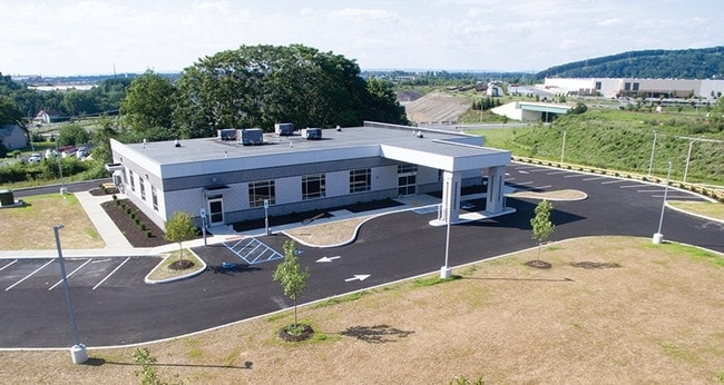
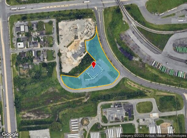
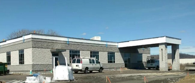
Property Record
1005 Harvard Ave, Bethlehem, PA 18015

NEARBY LISTINGS FOR SALE OR LEASE
Property Detail
1005 Harvard Ave
P7-14-1B-1-0204
Lvip Vii
Officebuilding
Northampton
X
Pennsylvania
42095C0327E
2.91 AC
2025
Lehigh Valley
2025
Philadelphia
011300
Allentown-Bethlehem-Easton, PA-NJ
8,066 SF
DEMOGRAPHICS near 1005 Harvard Ave
1 Mile
3 Mile
5 Mile
2024 Total Population
4,731
67,374
137,196
2029 Population
4,762
67,637
137,831
Pop Growth 2024-2029
+ 0.66%
+ 0.39%
+ 0.46%
Average Age
38
38
41
2024 Total Households
1,845
25,588
53,233
HH Growth 2024-2029
+ 0.60%
+ 0.56%
+ 0.54%
Median Household Inc
$60,567
$61,434
$72,754
Avg Household Size
2.40
2.30
2.40
2024 Avg HH Vehicles
2.00
2.00
2.00
Median Home Value
$233,892
$210,830
$249,967
Median Year Built
1970
1951
1962
Nearby Places
Map Layers
Map Styles
 Street
 Aerial
- Restaurants
- Banks
- Shops
- Fitness
- Groceries
PUBLIC TRANSPORTATION
AIRPORT
Lehigh Valley International
DRIVE
WALK
Distance
Lehigh Valley International
19 min
8.9 mi
Freight Ports
Port of Philadelphia
DRIVE
WALK
Distance
Port of Philadelphia
86 min
51.6 mi
SALE & LEASE HISTORY
LISTING DATE
SALE/LEASE

Jun 12, 2017
For Sale
Nearby Properties
Address
Land Use
TOTAL SIZE
Lot Size
Zoning
Address
Land Use
TOTAL SIZE
Lot Size
Zoning
541,843 SF
35.82 AC
INST
Address
Land Use
TOTAL SIZE
Lot Size
Zoning
425,507 SF
52.58 AC
HI
Address
Land Use
TOTAL SIZE
Lot Size
Zoning
1,197,396 SF
57.03 AC
HI
Address
Land Use
TOTAL SIZE
Lot Size
Zoning
12,838 SF
36.50 AC
IP
Address
Land Use
TOTAL SIZE
Lot Size
Zoning
1,200,000 SF
107.27 AC
HI
Address
Land Use
TOTAL SIZE
Lot Size
Zoning
1,710,800 SF
68.08 AC
HI
Address
Land Use
TOTAL SIZE
Lot Size
Zoning
26,653 SF
13.51 AC
HI
Address
Land Use
TOTAL SIZE
Lot Size
Zoning
11,856 SF
454.48 AC
CM
Address
Land Use
TOTAL SIZE
Lot Size
Zoning
800,280 SF
18.20 AC
HI
Address
Land Use
TOTAL SIZE
Lot Size
Zoning
332,641 SF
2.27 AC
HI
Address
Land Use
TOTAL SIZE
Lot Size
Zoning
800,250 SF
40.07 AC
HI
Address
Land Use
TOTAL SIZE
Lot Size
Zoning
676,788 SF
39.39 AC
HI
Address
Land Use
TOTAL SIZE
Lot Size
Zoning
3,400 SF
65.07 AC
RM
Address
Land Use
TOTAL SIZE
Lot Size
Zoning
10,572 SF
54.17 AC
IP
Address
Land Use
TOTAL SIZE
Lot Size
Zoning
230,780 SF
14.48 AC
I
Address
Land Use
TOTAL SIZE
Lot Size
Zoning
421,883 SF
34.66 AC
HI
Address
Land Use
TOTAL SIZE
Lot Size
Zoning
347,514 SF
10.27 AC
RM
Address
Land Use
TOTAL SIZE
Lot Size
Zoning
168,984 SF
20.31 AC
I
Address
Land Use
TOTAL SIZE
Lot Size
Zoning
31,442 SF
9.87 AC
IP
Address
Land Use
TOTAL SIZE
Lot Size
Zoning
39,016 SF
17.40 AC
RG
Address
Land Use
TOTAL SIZE
Lot Size
Zoning
24,354 SF
11.16 AC
HI
Address
Land Use
TOTAL SIZE
Lot Size
Zoning
103,214 SF
2.55 AC
RT
Address
Land Use
TOTAL SIZE
Lot Size
Zoning
21,462 SF
255.01 AC
IP
Address
Land Use
TOTAL SIZE
Lot Size
Zoning
809,830 SF
25.68 AC
HI
Address
Land Use
TOTAL SIZE
Lot Size
Zoning
809,830 SF
21.93 AC
HI
Address
Land Use
TOTAL SIZE
Lot Size
Zoning
85,304 SF
0.38 AC
INST
Address
Land Use
TOTAL SIZE
Lot Size
Zoning
20,000 SF
2.81 AC
HI
Address
Land Use
TOTAL SIZE
Lot Size
Zoning
536,726 SF
12.02 AC
HI
Address
Land Use
TOTAL SIZE
Lot Size
Zoning
209,356 SF
3.43 AC
I
Address
Land Use
TOTAL SIZE
Lot Size
Zoning
75,833 SF
10.64 AC
IP
The World's #1 Commercial Real Estate Marketplace
Connect with us
© 2025 CoStar Group
The information above has been obtained from sources believed reliable. While we do not doubt its accuracy we have not verified it and make no guarantee, warranty or representation about it. It is your responsibility to independently confirm its accuracy and completeness. Any projections, opinions, assumptions, or estimates used are for example only and do not represent the current or future performance of the property. The value of this transaction to you depends on tax and other factors which should be evaluated by your tax, financial, and legal advisors. You and your advisors should conduct a careful, independent investigation of the property to determine to your satisfaction the suitability of the property for your needs.