Property Record
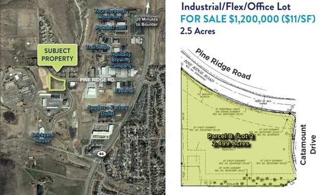
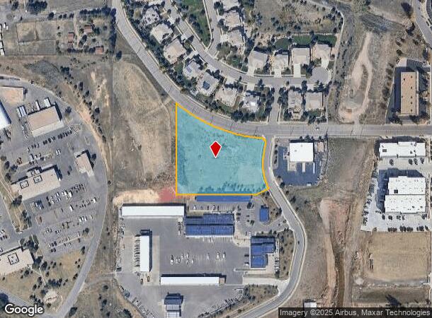
1005 Pine Ridge Rd, Golden, CO 80403
NEARBY LISTINGS FOR SALE OR LEASE
-
-
View all Golden listings for sale on LoopNet.com
Property Detail
1005 Pine Ridge Rd
Denver-Aurora-Centennial, CO
Catamount Sub Filing 1
30-212-16-002
SECTION 21 TOWNSHIP 03 RANGE 70 QTR NW SUBDIVISIONCD 114805 SUBDIVISIONNAME CATAMOUNT SUB FILING 1 BLOCK LOT 0002 SIZE: 108900 TRACT VALUE: 2.500
Industrialgeneral
Jefferson
X
Colorado
08059C0188G
2
2023
2.50 AC
2024
West Denver
009858
Denver
DEMOGRAPHICS near 1005 Pine Ridge Rd
1 Mile
3 Mile
5 Mile
2024 Total Population
2,946
18,215
51,103
2029 Population
2,967
18,194
50,699
Pop Growth 2024-2029
+ 0.71%
(0.12%)
(0.79%)
Average Age
44
39
41
2024 Total Households
1,229
6,827
19,897
HH Growth 2024-2029
+ 0.81%
+ 0.07%
(0.82%)
Median Household Inc
$142,791
$106,797
$113,299
Avg Household Size
2.40
2.30
2.40
2024 Avg HH Vehicles
2.00
2.00
2.00
Median Home Value
$789,730
$742,574
$720,556
Median Year Built
1993
1987
1991
Nearby Places
Map Layers
Map Styles
 Street
 Aerial
- Restaurants
- Banks
- Shops
- Fitness
- Groceries
PUBLIC TRANSPORTATION
COMMUTER RAIL
Wheat Ridge - Ward Station Track 1 (Union Station to Wheat Ridge Ward Station - Regional Transportation District)
DRIVE
WALK
Distance
Wheat Ridge - Ward Station Track 1 (Union Station to Wheat Ridge Ward Station - Regional Transportation District)
15 min
8.7 mi
Arvada Ridge Station Track 1 (Union Station to Wheat Ridge Ward Station - Regional Transportation District)
DRIVE
WALK
Distance
Arvada Ridge Station Track 1 (Union Station to Wheat Ridge Ward Station - Regional Transportation District)
16 min
9.7 mi
Freight Ports
Tulsa Port Of Catoosa
DRIVE
WALK
Distance
Tulsa Port Of Catoosa
746 min
722.8 mi
SALE & LEASE HISTORY
LISTING DATE
SALE/LEASE

Sep 24, 2016
For Sale
Sep 10, 2019
For Sale
Nov 10, 2022
For Sale
Mar 11, 2019
For Sale
Mar 11, 2019
For Sale
Apr 25, 2023
For Sale
Nearby Properties
Address
Land Use
TOTAL SIZE
Lot Size
Zoning
Address
Land Use
TOTAL SIZE
Lot Size
Zoning
3,357,529 SF
32.87 AC
Address
Land Use
TOTAL SIZE
Lot Size
Zoning
69,819 SF
1,402.21 AC
R1
Address
Land Use
TOTAL SIZE
Lot Size
Zoning
589,966 SF
23.48 AC
Address
Land Use
TOTAL SIZE
Lot Size
Zoning
1,044.03 AC
A2
Address
Land Use
TOTAL SIZE
Lot Size
Zoning
156,531 SF
8.20 AC
Address
Land Use
TOTAL SIZE
Lot Size
Zoning
188,554 SF
33.28 AC
Address
Land Use
TOTAL SIZE
Lot Size
Zoning
1,115,227 SF
84.74 AC
I2
Address
Land Use
TOTAL SIZE
Lot Size
Zoning
192,500 SF
10.97 AC
Address
Land Use
TOTAL SIZE
Lot Size
Zoning
260,325 SF
13.70 AC
Address
Land Use
TOTAL SIZE
Lot Size
Zoning
350,722 SF
73.85 AC
R1
Address
Land Use
TOTAL SIZE
Lot Size
Zoning
391,506 SF
10.02 AC
Address
Land Use
TOTAL SIZE
Lot Size
Zoning
240,059 SF
58.36 AC
Address
Land Use
TOTAL SIZE
Lot Size
Zoning
64,883 SF
4.74 AC
Address
Land Use
TOTAL SIZE
Lot Size
Zoning
82,432 SF
1.62 AC
Address
Land Use
TOTAL SIZE
Lot Size
Zoning
180,193 SF
4.58 AC
Address
Land Use
TOTAL SIZE
Lot Size
Zoning
65,682 SF
6 AC
Address
Land Use
TOTAL SIZE
Lot Size
Zoning
910,977 SF
19.78 AC
Address
Land Use
TOTAL SIZE
Lot Size
Zoning
102,645 SF
3.94 AC
Address
Land Use
TOTAL SIZE
Lot Size
Zoning
143,558 SF
2.93 AC
Address
Land Use
TOTAL SIZE
Lot Size
Zoning
60,754 SF
9.60 AC
A2
Address
Land Use
TOTAL SIZE
Lot Size
Zoning
12,652 SF
13.80 AC
PD
Address
Land Use
TOTAL SIZE
Lot Size
Zoning
46,806 SF
4.22 AC
Address
Land Use
TOTAL SIZE
Lot Size
Zoning
43,486 SF
2.12 AC
Address
Land Use
TOTAL SIZE
Lot Size
Zoning
106,799 SF
1.97 AC
Address
Land Use
TOTAL SIZE
Lot Size
Zoning
44,508 SF
3.67 AC
Address
Land Use
TOTAL SIZE
Lot Size
Zoning
73,014 SF
4.48 AC
Address
Land Use
TOTAL SIZE
Lot Size
Zoning
10,698 SF
379.49 AC
PD
Address
Land Use
TOTAL SIZE
Lot Size
Zoning
191,996 SF
3 AC
Address
Land Use
TOTAL SIZE
Lot Size
Zoning
87,427 SF
3.96 AC
Address
Land Use
TOTAL SIZE
Lot Size
Zoning
53,381 SF
5 AC
The World's #1 Commercial Real Estate Marketplace
Connect with us
© 2026 CoStar Group
The information above has been obtained from sources believed reliable. While we do not doubt its accuracy we have not verified it and make no guarantee, warranty or representation about it. It is your responsibility to independently confirm its accuracy and completeness. Any projections, opinions, assumptions, or estimates used are for example only and do not represent the current or future performance of the property. The value of this transaction to you depends on tax and other factors which should be evaluated by your tax, financial, and legal advisors. You and your advisors should conduct a careful, independent investigation of the property to determine to your satisfaction the suitability of the property for your needs.