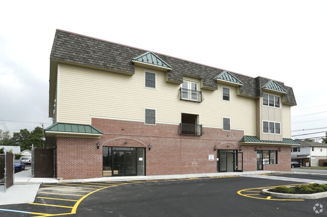
Property Record
1005 Rahway Ave, Avenel, NJ 07001


NEARBY LISTINGS FOR SALE OR LEASE
Property Detail
1005 Rahway Ave
New York-Jersey City-White Plains, NY-NJ
Avenel Gardens
25-00859-13-00001-02
225 X 100
Vacantlandnec
Middlesex
X
New Jersey
34023C0059F
1.2
2024
0.52 AC
2025
North Middlesex County
002703
Northern New Jersey
1,680 SF
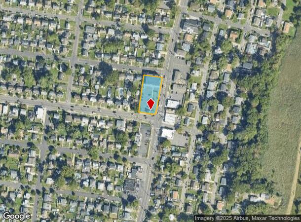
DEMOGRAPHICS near 1005 Rahway Ave
1 Mile
3 Mile
5 Mile
2024 Total Population
14,788
124,657
375,253
2029 Population
14,619
123,615
370,210
Pop Growth 2024-2029
(1.14%)
(0.84%)
(1.34%)
Average Age
39
40
40
2024 Total Households
5,482
44,523
131,708
HH Growth 2024-2029
(1.33%)
(0.94%)
(1.39%)
Median Household Inc
$92,068
$91,602
$91,739
Avg Household Size
2.60
2.70
2.80
2024 Avg HH Vehicles
2.00
2.00
2.00
Median Home Value
$327,913
$350,321
$421,080
Median Year Built
1967
1963
1966
Nearby Places
Map Layers
Map Styles
 Street
 Aerial
- Restaurants
- Banks
- Shops
- Fitness
- Groceries
SALE & LEASE HISTORY
LISTING DATE
SALE/LEASE

Sep 01, 2021
For Lease
Jan 10, 2024
For Lease
Nearby Properties
Address
Land Use
TOTAL SIZE
Lot Size
Zoning
Address
Land Use
TOTAL SIZE
Lot Size
Zoning
794,430 SF
36.09 AC
R50
Address
Land Use
TOTAL SIZE
Lot Size
Zoning
329,350 SF
15.99 AC
Address
Land Use
TOTAL SIZE
Lot Size
Zoning
10 SF
0.64 AC
Address
Land Use
TOTAL SIZE
Lot Size
Zoning
Address
Land Use
TOTAL SIZE
Lot Size
Zoning
404,985 SF
15.32 AC
R25
Address
Land Use
TOTAL SIZE
Lot Size
Zoning
37 AC
Address
Land Use
TOTAL SIZE
Lot Size
Zoning
196,382 SF
25.95 AC
Address
Land Use
TOTAL SIZE
Lot Size
Zoning
1 SF
37 AC
Address
Land Use
TOTAL SIZE
Lot Size
Zoning
102.29 AC
Address
Land Use
TOTAL SIZE
Lot Size
Zoning
348,466 SF
15.98 AC
LI
Address
Land Use
TOTAL SIZE
Lot Size
Zoning
360,082 SF
22.45 AC
R50
Address
Land Use
TOTAL SIZE
Lot Size
Zoning
365,784 SF
12.73 AC
HIA
Address
Land Use
TOTAL SIZE
Lot Size
Zoning
78.47 AC
Address
Land Use
TOTAL SIZE
Lot Size
Zoning
37.32 AC
S-3B
Address
Land Use
TOTAL SIZE
Lot Size
Zoning
298,080 SF
13.79 AC
LI
Address
Land Use
TOTAL SIZE
Lot Size
Zoning
286,290 SF
21.24 AC
R50
Address
Land Use
TOTAL SIZE
Lot Size
Zoning
10,240 SF
22.96 AC
LI
Address
Land Use
TOTAL SIZE
Lot Size
Zoning
232,134 SF
12.24 AC
LI
Address
Land Use
TOTAL SIZE
Lot Size
Zoning
1.64 AC
R-25
Address
Land Use
TOTAL SIZE
Lot Size
Zoning
245,272 SF
18.54 AC
R50
Address
Land Use
TOTAL SIZE
Lot Size
Zoning
11.63 AC
S-3D
Address
Land Use
TOTAL SIZE
Lot Size
Zoning
263,925 SF
11.98 AC
R50
Address
Land Use
TOTAL SIZE
Lot Size
Zoning
0.14 AC
C-4
Address
Land Use
TOTAL SIZE
Lot Size
Zoning
55.47 AC
Address
Land Use
TOTAL SIZE
Lot Size
Zoning
214,392 SF
11.79 AC
R50
Address
Land Use
TOTAL SIZE
Lot Size
Zoning
71.66 AC
M-3
Address
Land Use
TOTAL SIZE
Lot Size
Zoning
131,140 SF
10 AC
LI
Address
Land Use
TOTAL SIZE
Lot Size
Zoning
Address
Land Use
TOTAL SIZE
Lot Size
Zoning
Address
Land Use
TOTAL SIZE
Lot Size
Zoning
400 SF
22.39 AC
R50
The World's #1 Commercial Real Estate Marketplace
Connect with us
© 2025 CoStar Group
The information above has been obtained from sources believed reliable. While we do not doubt its accuracy we have not verified it and make no guarantee, warranty or representation about it. It is your responsibility to independently confirm its accuracy and completeness. Any projections, opinions, assumptions, or estimates used are for example only and do not represent the current or future performance of the property. The value of this transaction to you depends on tax and other factors which should be evaluated by your tax, financial, and legal advisors. You and your advisors should conduct a careful, independent investigation of the property to determine to your satisfaction the suitability of the property for your needs.