Property Record
1005 Stafford Way, Yuba City, CA 95991
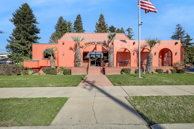
This Property Is For Sale
NEARBY LISTINGS FOR SALE OR LEASE
Property Detail
1005 Stafford Way
Sacramento
Parcel Map 429
Yuba City, CA
FORMERLY @: 01-051-007- - 12-03-2003 PARCEL 2 PARCEL MAP 429
51-331-007
Sutter
Commercialnec
California
2024
2
2025
0.91 AC
050102
Outer Sutter County
6,483 SF
DEMOGRAPHICS near 1005 Stafford Way
1 Mile
3 Mile
5 Mile
2024 Total Population
16,870
79,204
114,445
2029 Population
16,718
79,584
117,183
Pop Growth 2024-2029
(0.90%)
+ 0.48%
+ 2.39%
Average Age
38
39
38
2024 Total Households
6,222
27,097
38,062
HH Growth 2024-2029
(0.88%)
+ 0.68%
+ 2.54%
Median Household Inc
$44,492
$60,154
$60,563
Avg Household Size
2.60
2.80
2.90
2024 Avg HH Vehicles
2.00
2.00
2.00
Median Home Value
$275,532
$345,008
$337,979
Median Year Built
1972
1978
1979
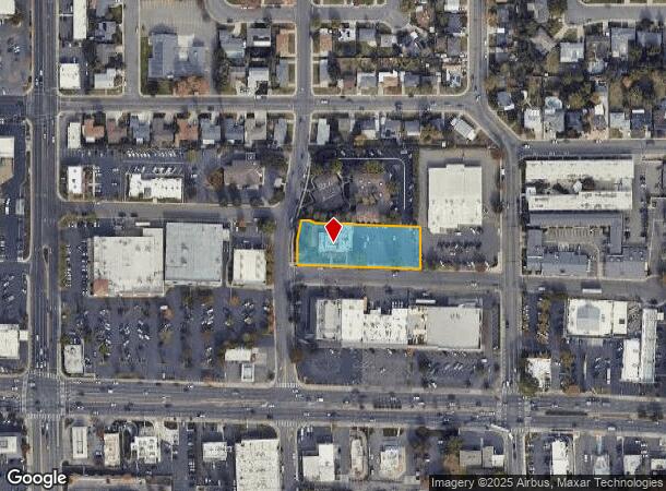
Nearby Places
Map Layers
Map Styles
 Street
 Aerial
- Restaurants
- Banks
- Shops
- Fitness
- Groceries
Nearby Properties
Address
Land Use
TOTAL SIZE
Lot Size
Zoning
Address
Land Use
TOTAL SIZE
Lot Size
Zoning
18,410 SF
0.77 AC
C-3
Address
Land Use
TOTAL SIZE
Lot Size
Zoning
30,734 SF
1.38 AC
C-3
Address
Land Use
TOTAL SIZE
Lot Size
Zoning
25,580 SF
9.48 AC
C3
Address
Land Use
TOTAL SIZE
Lot Size
Zoning
98,830 SF
0.40 AC
C-3
Address
Land Use
TOTAL SIZE
Lot Size
Zoning
1,028,560 SF
52.30 AC
M1
Address
Land Use
TOTAL SIZE
Lot Size
Zoning
48,348 SF
3.25 AC
Address
Land Use
TOTAL SIZE
Lot Size
Zoning
143,368 SF
11.40 AC
Address
Land Use
TOTAL SIZE
Lot Size
Zoning
92,312 SF
17.04 AC
Address
Land Use
TOTAL SIZE
Lot Size
Zoning
51,371 SF
10.13 AC
Address
Land Use
TOTAL SIZE
Lot Size
Zoning
120,622 SF
2.25 AC
Address
Land Use
TOTAL SIZE
Lot Size
Zoning
259,011 SF
14.20 AC
M1
Address
Land Use
TOTAL SIZE
Lot Size
Zoning
147,546 SF
7.55 AC
R3
Address
Land Use
TOTAL SIZE
Lot Size
Zoning
49,817 SF
2.81 AC
C3
Address
Land Use
TOTAL SIZE
Lot Size
Zoning
55,702 SF
3.16 AC
Address
Land Use
TOTAL SIZE
Lot Size
Zoning
18,675 SF
2.98 AC
C3
Address
Land Use
TOTAL SIZE
Lot Size
Zoning
176,181 SF
6.99 AC
CM
Address
Land Use
TOTAL SIZE
Lot Size
Zoning
74,040 SF
5.97 AC
R3
Address
Land Use
TOTAL SIZE
Lot Size
Zoning
53,600 SF
8.15 AC
Address
Land Use
TOTAL SIZE
Lot Size
Zoning
50,270 SF
4.16 AC
CO
Address
Land Use
TOTAL SIZE
Lot Size
Zoning
137,178 SF
11.01 AC
C3
Address
Land Use
TOTAL SIZE
Lot Size
Zoning
140,846 SF
12.98 AC
C3
Address
Land Use
TOTAL SIZE
Lot Size
Zoning
138,490 SF
18.72 AC
C3
Address
Land Use
TOTAL SIZE
Lot Size
Zoning
48,117 SF
1.81 AC
R1
Address
Land Use
TOTAL SIZE
Lot Size
Zoning
115,058 SF
13.03 AC
Address
Land Use
TOTAL SIZE
Lot Size
Zoning
Address
Land Use
TOTAL SIZE
Lot Size
Zoning
37,854 SF
6 AC
C3
Address
Land Use
TOTAL SIZE
Lot Size
Zoning
105,160 SF
8.99 AC
Address
Land Use
TOTAL SIZE
Lot Size
Zoning
56,257 SF
1.73 AC
Address
Land Use
TOTAL SIZE
Lot Size
Zoning
203,184 SF
17.82 AC
C3
Address
Land Use
TOTAL SIZE
Lot Size
Zoning
39,340 SF
6.51 AC
The World's #1 Commercial Real Estate Marketplace
Connect with us
© 2026 CoStar Group
The information above has been obtained from sources believed reliable. While we do not doubt its accuracy we have not verified it and make no guarantee, warranty or representation about it. It is your responsibility to independently confirm its accuracy and completeness. Any projections, opinions, assumptions, or estimates used are for example only and do not represent the current or future performance of the property. The value of this transaction to you depends on tax and other factors which should be evaluated by your tax, financial, and legal advisors. You and your advisors should conduct a careful, independent investigation of the property to determine to your satisfaction the suitability of the property for your needs.