Property Record
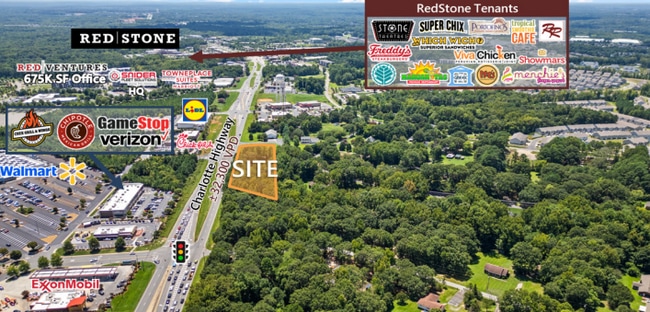
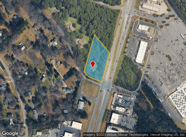
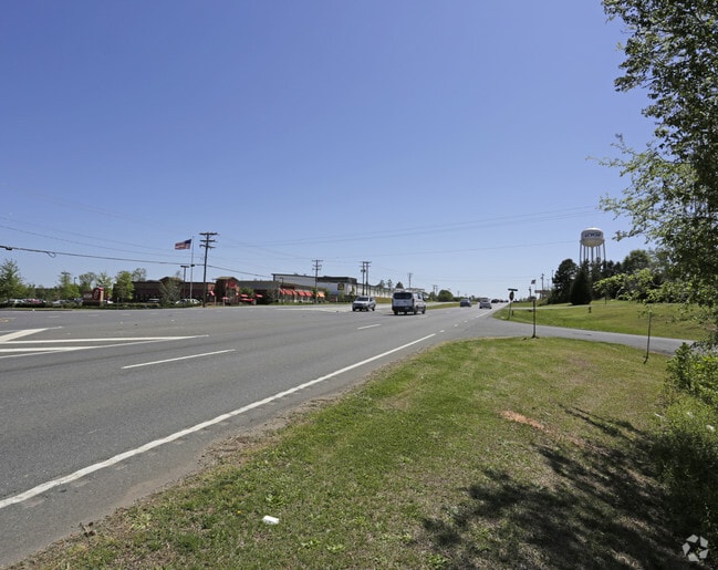
10051 Charlotte Hwy, Fort Mill, SC 29707
This Property Is For Sale
NEARBY LISTINGS FOR SALE OR LEASE
-
-
-
-
No Photo
-
-
-
-
View all Fort Mill listings for sale on LoopNet.com
Property Detail
10051 Charlotte Hwy
Charlotte-Concord-Gastonia, NC-SC
Elmsbrook Subdivision
0005-00-051.00
Lancaster
Sfr
South Carolina
X
1.55 AC
45057C0040E
Lancaster County
1,716 SF
Charlotte
DEMOGRAPHICS near 10051 Charlotte Hwy
1 Mile
3 Mile
5 Mile
2024 Total Population
4,738
59,640
141,386
2029 Population
5,702
66,406
156,051
Pop Growth 2024-2029
+ 20.35%
+ 11.34%
+ 10.37%
Average Age
39
38
39
2024 Total Households
1,882
21,443
52,167
HH Growth 2024-2029
+ 20.40%
+ 11.50%
+ 10.33%
Median Household Inc
$111,532
$126,110
$117,282
Avg Household Size
2.50
2.80
2.70
2024 Avg HH Vehicles
2.00
2.00
2.00
Median Home Value
$295,693
$434,464
$413,536
Median Year Built
2010
2005
2003
Nearby Places
- Restaurants
- Banks
- Shops
- Fitness
- Groceries
PUBLIC TRANSPORTATION
AIRPORT
Charlotte/Douglas International
DRIVE
WALK
Distance
Charlotte/Douglas International
29 min
17.6 mi
Concord-Padgett Regional
DRIVE
WALK
Distance
Concord-Padgett Regional
48 min
38.9 mi
Freight Ports
North Charleston Terminal
DRIVE
WALK
Distance
North Charleston Terminal
215 min
188.7 mi
Nearby Properties
Address
Land Use
TOTAL SIZE
Lot Size
Zoning
Address
Land Use
TOTAL SIZE
Lot Size
Zoning
425,591 SF
31.58 AC
MX1
Address
Land Use
TOTAL SIZE
Lot Size
Zoning
465,462 SF
23.76 AC
CC
Address
Land Use
TOTAL SIZE
Lot Size
Zoning
294,279 SF
27.77 AC
R12MFCD
Address
Land Use
TOTAL SIZE
Lot Size
Zoning
215,600 SF
6.97 AC
R3
Address
Land Use
TOTAL SIZE
Lot Size
Zoning
348,409 SF
26.08 AC
R17MFCD
Address
Land Use
TOTAL SIZE
Lot Size
Zoning
287,004 SF
14.52 AC
R3
Address
Land Use
TOTAL SIZE
Lot Size
Zoning
321,129 SF
23.59 AC
MX2
Address
Land Use
TOTAL SIZE
Lot Size
Zoning
293,128 SF
22.70 AC
MX2
Address
Land Use
TOTAL SIZE
Lot Size
Zoning
353,996 SF
58.49 AC
R3
Address
Land Use
TOTAL SIZE
Lot Size
Zoning
195,262 SF
4.56 AC
Address
Land Use
TOTAL SIZE
Lot Size
Zoning
186,651 SF
7.40 AC
CC
Address
Land Use
TOTAL SIZE
Lot Size
Zoning
201,638 SF
7.44 AC
R-12PUD
Address
Land Use
TOTAL SIZE
Lot Size
Zoning
254,527 SF
9.34 AC
MX2
Address
Land Use
TOTAL SIZE
Lot Size
Zoning
234,912 SF
11.60 AC
R3
Address
Land Use
TOTAL SIZE
Lot Size
Zoning
157,468 SF
15.84 AC
CC
Address
Land Use
TOTAL SIZE
Lot Size
Zoning
211,609 SF
6.91 AC
UR2CD
Address
Land Use
TOTAL SIZE
Lot Size
Zoning
269,684 SF
0.64 AC
CC
Address
Land Use
TOTAL SIZE
Lot Size
Zoning
182,180 SF
7.31 AC
MX2
Address
Land Use
TOTAL SIZE
Lot Size
Zoning
160,395 SF
34.25 AC
R3
Address
Land Use
TOTAL SIZE
Lot Size
Zoning
137,210 SF
4.52 AC
Address
Land Use
TOTAL SIZE
Lot Size
Zoning
90,466 SF
105.72 AC
INST
Address
Land Use
TOTAL SIZE
Lot Size
Zoning
98,222 SF
2.84 AC
Address
Land Use
TOTAL SIZE
Lot Size
Zoning
120,698 SF
5.18 AC
Address
Land Use
TOTAL SIZE
Lot Size
Zoning
74,000 SF
20.51 AC
O-1(CD)
Address
Land Use
TOTAL SIZE
Lot Size
Zoning
121,180 SF
20.23 AC
INST
Address
Land Use
TOTAL SIZE
Lot Size
Zoning
86,368 SF
11.28 AC
NS
Address
Land Use
TOTAL SIZE
Lot Size
Zoning
133,155 SF
5.57 AC
I-1(CD)
Address
Land Use
TOTAL SIZE
Lot Size
Zoning
3,948 SF
14.70 AC
MUDD-O
Address
Land Use
TOTAL SIZE
Lot Size
Zoning
74,604 SF
2.26 AC
Address
Land Use
TOTAL SIZE
Lot Size
Zoning
77,646 SF
13.89 AC
The World's #1 Commercial Real Estate Marketplace
Connect with us
© 2025 CoStar Group
The information above has been obtained from sources believed reliable. While we do not doubt its accuracy we have not verified it and make no guarantee, warranty or representation about it. It is your responsibility to independently confirm its accuracy and completeness. Any projections, opinions, assumptions, or estimates used are for example only and do not represent the current or future performance of the property. The value of this transaction to you depends on tax and other factors which should be evaluated by your tax, financial, and legal advisors. You and your advisors should conduct a careful, independent investigation of the property to determine to your satisfaction the suitability of the property for your needs.