Property Record
10056 Hickman Rd, Clive, IA 50325
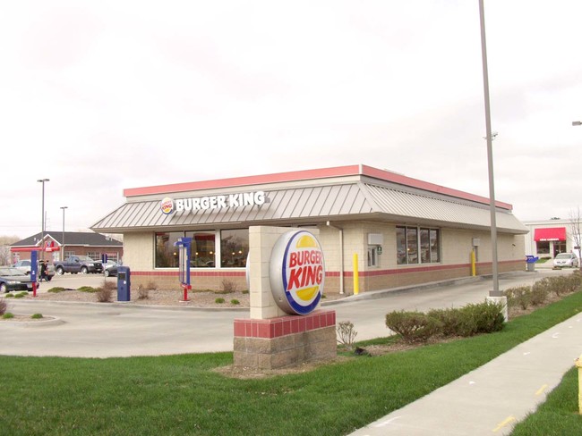


Property Detail
10056 Hickman Rd
291-00338000000
LT 8 HICKMAN CENTURY SUB DIV
Carwash
POLK
C-1
Iowa
AE The base floodplain where base flood elevations are provided. AE Zones are now used on new format FIRMs instead of A1-A30 Zones.
8
2024
1.11 AC
2025
Western Suburbs
011203
Des Moines
4,763 SF
Des Moines-West Des Moines, IA
NEARBY LISTINGS FOR SALE OR LEASE
DEMOGRAPHICS near 10056 Hickman Rd
1 mile
3 mile
5 mile
2025 Total Population
5,868
74,467
203,941
2030 Population
6,082
76,948
214,898
Pop Growth 2025-2030
+ 3.65%
+ 3.33%
+ 5.37%
Average Age
42
40
39
2025 Total Households
2,466
31,251
85,494
HH Growth 2025-2030
+ 3.85%
+ 3.50%
+ 5.52%
Median Household Inc
$105,892
$92,347
$91,974
Avg Household Size
2.40
2.30
2.30
2025 Avg HH Vehicles
2.00
2.00
2.00
Median Home Value
$324,891
$298,276
$302,760
Median Year Built
1976
1979
1987
Nearby Places
Map Layers
Map Styles
 Street
 Aerial
Layers
 Traffic
 Biking
Places
Listings with unknown addresses are not visible on the map
- Restaurants
- Banks
- Shops
- Fitness
- Groceries
PUBLIC TRANSPORTATION
AIRPORT
Des Moines International
Drive
Walk
Distance
Des Moines International
20 min
9.2 mi
Freight Ports
Port Milwaukee
Drive
Walk
Distance
Port Milwaukee
423 min
379.7 mi
Nearby Properties
Address
Land Use
TOTAL SIZE
Lot Size
Zoning
Address
Land Use
TOTAL SIZE
Lot Size
Zoning
472,476 SF
12.48 AC
PUD OFFICE
Address
Land Use
TOTAL SIZE
Lot Size
Zoning
18,093 SF
48.92 AC
Address
Land Use
TOTAL SIZE
Lot Size
Zoning
255,521 SF
60.90 AC
RE
Address
Land Use
TOTAL SIZE
Lot Size
Zoning
422,683 SF
46.57 AC
PCP
Address
Land Use
TOTAL SIZE
Lot Size
Zoning
457,056 SF
26.01 AC
Address
Land Use
TOTAL SIZE
Lot Size
Zoning
407,183 SF
17.02 AC
PUD
Address
Land Use
TOTAL SIZE
Lot Size
Zoning
415,320 SF
51.16 AC
PUD
Address
Land Use
TOTAL SIZE
Lot Size
Zoning
241,324 SF
21.67 AC
PUD B&C
Address
Land Use
TOTAL SIZE
Lot Size
Zoning
322,220 SF
7.61 AC
Address
Land Use
TOTAL SIZE
Lot Size
Zoning
275,227 SF
18.31 AC
PCP
Address
Land Use
TOTAL SIZE
Lot Size
Zoning
196,904 SF
26.10 AC
PUD
Address
Land Use
TOTAL SIZE
Lot Size
Zoning
182,866 SF
10.21 AC
Address
Land Use
TOTAL SIZE
Lot Size
Zoning
189,691 SF
27.03 AC
PCP
Address
Land Use
TOTAL SIZE
Lot Size
Zoning
572,809 SF
42.13 AC
M-2
Address
Land Use
TOTAL SIZE
Lot Size
Zoning
367,386 SF
24.31 AC
PUD
Address
Land Use
TOTAL SIZE
Lot Size
Zoning
341,024 SF
12.15 AC
RH
Address
Land Use
TOTAL SIZE
Lot Size
Zoning
67,691 SF
7.30 AC
Address
Land Use
TOTAL SIZE
Lot Size
Zoning
151,344 SF
10.43 AC
C-3
Address
Land Use
TOTAL SIZE
Lot Size
Zoning
280,396 SF
34.25 AC
Address
Land Use
TOTAL SIZE
Lot Size
Zoning
195,931 SF
13.66 AC
Address
Land Use
TOTAL SIZE
Lot Size
Zoning
221,654 SF
26.38 AC
PUD MD
Address
Land Use
TOTAL SIZE
Lot Size
Zoning
83,370 SF
0.98 AC
C-3
Address
Land Use
TOTAL SIZE
Lot Size
Zoning
79,916 SF
7.82 AC
PUD OFFICE
Address
Land Use
TOTAL SIZE
Lot Size
Zoning
308,117 SF
18.33 AC
RH
Address
Land Use
TOTAL SIZE
Lot Size
Zoning
80,045 SF
5.07 AC
C-3
Address
Land Use
TOTAL SIZE
Lot Size
Zoning
168,898 SF
17.54 AC
PUD
Address
Land Use
TOTAL SIZE
Lot Size
Zoning
235,620 SF
13.18 AC
RH
Address
Land Use
TOTAL SIZE
Lot Size
Zoning
212,500 SF
10.20 AC
Address
Land Use
TOTAL SIZE
Lot Size
Zoning
94,136 SF
18.48 AC
PUD
Address
Land Use
TOTAL SIZE
Lot Size
Zoning
121,824 SF
14.72 AC
C-3
The World's #1 Commercial Real Estate Marketplace
Connect with us
© 2026 CoStar Group
The information above has been obtained from sources believed reliable. While we do not doubt its accuracy we have not verified it and make no guarantee, warranty or representation about it. It is your responsibility to independently confirm its accuracy and completeness. Any projections, opinions, assumptions, or estimates used are for example only and do not represent the current or future performance of the property. The value of this transaction to you depends on tax and other factors which should be evaluated by your tax, financial, and legal advisors. You and your advisors should conduct a careful, independent investigation of the property to determine to your satisfaction the suitability of the property for your needs.