Property Record
10059 E Highland Rd, Howell, MI 48843
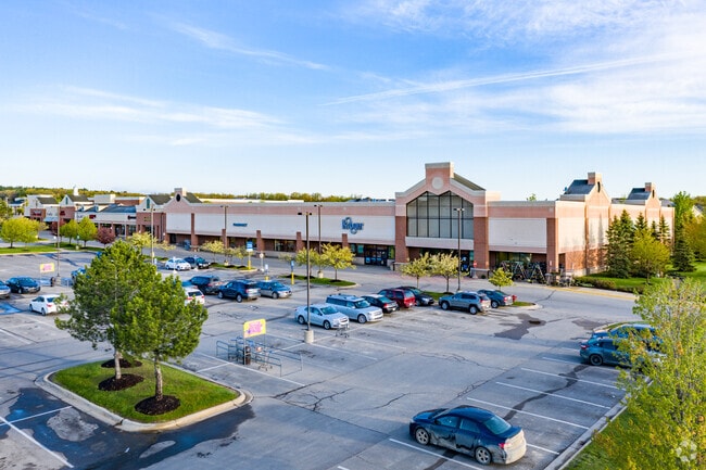

Property Detail
10059 E Highland Rd
08-21-300-026
COM AT THE SW COR OF SEC 21, T3N, R6E,HARTLAND TOWNSHIP, LIVINGSTON COUNTY, MICHIGAN: TH N88*25'36"E 190.21 FT ALONG THE S LN
Commercialnec
LIVINGSTON
PDGC
Michigan
B and X Area of moderate flood hazard, usually the area between the limits of the 100-year and 500-year floods.
12.09 AC
2025
Livingston County
2025
Detroit
713300
Detroit-Warren-Dearborn, MI
78,200 SF
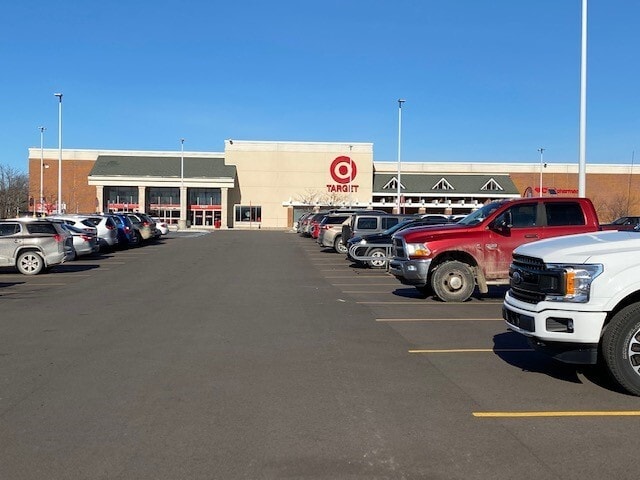
NEARBY LISTINGS FOR SALE OR LEASE
DEMOGRAPHICS near 10059 E Highland Rd
1 mile
3 mile
5 mile
2025 Total Population
3,192
13,131
31,115
2030 Population
3,244
13,305
31,494
Pop Growth 2025-2030
+ 1.63%
+ 1.33%
+ 1.22%
Average Age
39
41
43
2025 Total Households
1,152
4,651
11,209
HH Growth 2025-2030
+ 1.65%
+ 1.35%
+ 1.26%
Median Household Inc
$103,626
$116,860
$116,280
Avg Household Size
2.80
2.80
2.70
2025 Avg HH Vehicles
2.00
2.00
2.00
Median Home Value
$378,880
$401,099
$400,317
Median Year Built
1999
1994
1992
Nearby Places
Map Layers
Map Styles
 Street
 Aerial
Layers
 Traffic
 Biking
Places
Listings with unknown addresses are not visible on the map
- Restaurants
- Banks
- Shops
- Fitness
- Groceries
PUBLIC TRANSPORTATION
AIRPORT
Bishop International
Drive
Walk
Distance
Bishop International
38 min
26.1 mi
Freight Ports
Port of Toledo
Drive
Walk
Distance
Port of Toledo
103 min
85.6 mi
SALE & LEASE HISTORY
LISTING DATE
SALE/LEASE

Sep 25, 2016
For Lease
Nearby Properties
Address
Land Use
TOTAL SIZE
Lot Size
Zoning
Address
Land Use
TOTAL SIZE
Lot Size
Zoning
75,102 SF
27.14 AC
CA
Address
Land Use
TOTAL SIZE
Lot Size
Zoning
286,618 SF
40.83 AC
PDMR
Address
Land Use
TOTAL SIZE
Lot Size
Zoning
139,245 SF
11.54 AC
PD
Address
Land Use
TOTAL SIZE
Lot Size
Zoning
55,117 SF
7.50 AC
PD
Address
Land Use
TOTAL SIZE
Lot Size
Zoning
163,707 SF
17.93 AC
CA
Address
Land Use
TOTAL SIZE
Lot Size
Zoning
188,508 SF
18.32 AC
PD
Address
Land Use
TOTAL SIZE
Lot Size
Zoning
42,134 SF
6.80 AC
CA
Address
Land Use
TOTAL SIZE
Lot Size
Zoning
55,626 SF
18.16 AC
PD
Address
Land Use
TOTAL SIZE
Lot Size
Zoning
123,800 SF
11.36 AC
GC
Address
Land Use
TOTAL SIZE
Lot Size
Zoning
115,115 SF
16.04 AC
PD
Address
Land Use
TOTAL SIZE
Lot Size
Zoning
60,400 SF
5.54 AC
LI
Address
Land Use
TOTAL SIZE
Lot Size
Zoning
18.68 AC
PD
Address
Land Use
TOTAL SIZE
Lot Size
Zoning
40,875 SF
5.86 AC
GC
Address
Land Use
TOTAL SIZE
Lot Size
Zoning
78,434 SF
10.92 AC
PD
Address
Land Use
TOTAL SIZE
Lot Size
Zoning
93,084 SF
9.11 AC
GC
Address
Land Use
TOTAL SIZE
Lot Size
Zoning
29.85 AC
GC
Address
Land Use
TOTAL SIZE
Lot Size
Zoning
5,628 SF
3.64 AC
GC
Address
Land Use
TOTAL SIZE
Lot Size
Zoning
23.69 AC
PD
Address
Land Use
TOTAL SIZE
Lot Size
Zoning
2.48 AC
GC
Address
Land Use
TOTAL SIZE
Lot Size
Zoning
94.50 AC
LI
Address
Land Use
TOTAL SIZE
Lot Size
Zoning
9,257 SF
79.69 AC
CA
Address
Land Use
TOTAL SIZE
Lot Size
Zoning
7,360 SF
4.95 AC
GC
Address
Land Use
TOTAL SIZE
Lot Size
Zoning
8,045 SF
1.73 AC
PD
Address
Land Use
TOTAL SIZE
Lot Size
Zoning
16.51 AC
GC
Address
Land Use
TOTAL SIZE
Lot Size
Zoning
25,540 SF
2.73 AC
GC
Address
Land Use
TOTAL SIZE
Lot Size
Zoning
48.61 AC
OS
Address
Land Use
TOTAL SIZE
Lot Size
Zoning
66,875 SF
5.77 AC
I
Address
Land Use
TOTAL SIZE
Lot Size
Zoning
28,800 SF
13.83 AC
NSC
Address
Land Use
TOTAL SIZE
Lot Size
Zoning
14,424 SF
2.92 AC
PD
The World's #1 Commercial Real Estate Marketplace
Connect with us
© 2026 CoStar Group
The information above has been obtained from sources believed reliable. While we do not doubt its accuracy we have not verified it and make no guarantee, warranty or representation about it. It is your responsibility to independently confirm its accuracy and completeness. Any projections, opinions, assumptions, or estimates used are for example only and do not represent the current or future performance of the property. The value of this transaction to you depends on tax and other factors which should be evaluated by your tax, financial, and legal advisors. You and your advisors should conduct a careful, independent investigation of the property to determine to your satisfaction the suitability of the property for your needs.