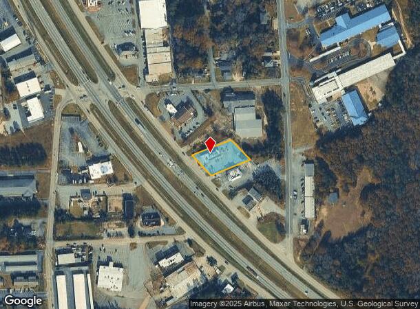
Property Record
1006 Highway 280 Byp, Phenix City, AL 36867
NEARBY LISTINGS FOR SALE OR LEASE
Property Detail
1006 Highway 280 Byp
05-05-16-04-001-001.001
Sec 16, T17n, R30e
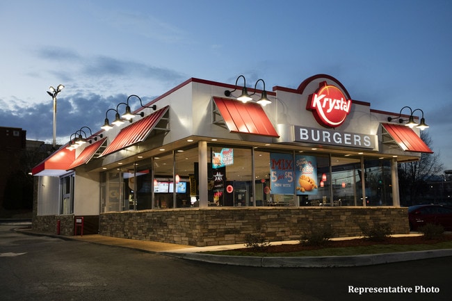
Restaurantdrivein
COM NE COR OF SE4 OF S16 T17NR30E BEING 135 X 200
X
Russell
01113C0159C
Alabama
2024
0.58 AC
2024
Phenix City
030700
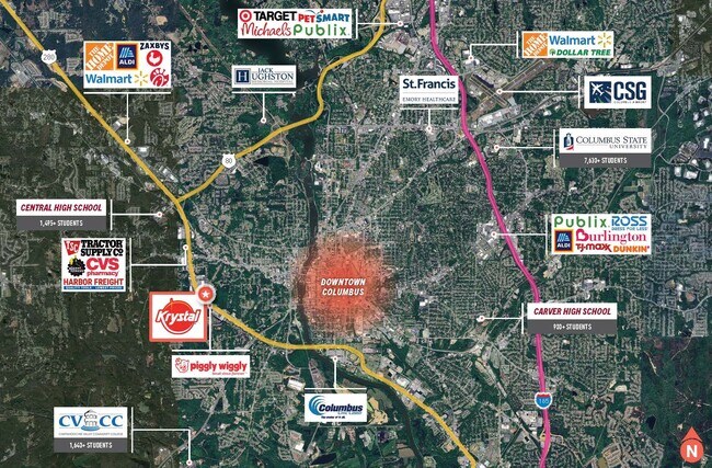
Columbus GA
2,541 SF
Columbus, GA-AL
DEMOGRAPHICS near 1006 Highway 280 Byp
1 Mile
3 Mile
5 Mile
2024 Total Population
5,246
39,602
104,309
2029 Population
5,108
39,464
105,160
Pop Growth 2024-2029
(2.63%)
(0.35%)
+ 0.82%
Average Age
37
37
38
2024 Total Households
2,188
16,937
43,229
HH Growth 2024-2029
(2.65%)
(0.30%)
+ 0.66%
Median Household Inc
$30,992
$33,494
$40,748
Avg Household Size
2.30
2.20
2.30
2024 Avg HH Vehicles
1.00
1.00
2.00
Median Home Value
$122,239
$140,003
$147,620
Median Year Built
1977
1975
1973
Nearby Places
Map Layers
Map Styles
 Street
 Aerial
- Restaurants
- Banks
- Shops
- Fitness
- Groceries
PUBLIC TRANSPORTATION
AIRPORT
Columbus
DRIVE
WALK
Distance
Columbus
15 min
8.8 mi
Freight Ports
Port of Panama City
DRIVE
WALK
Distance
Port of Panama City
230 min
182.9 mi
SALE & LEASE HISTORY
LISTING DATE
SALE/LEASE

Nov 26, 2018
For Sale
Nov 15, 2018
For Sale
Nov 07, 2018
For Sale
Mar 21, 2019
For Sale
Mar 12, 2019
For Sale
Mar 12, 2019
For Sale
Jan 15, 2019
For Sale
Jan 02, 2019
For Sale
Dec 28, 2018
For Sale
Apr 09, 2025
For Sale
Nearby Properties
Address
Land Use
TOTAL SIZE
Lot Size
Zoning
Address
Land Use
TOTAL SIZE
Lot Size
Zoning
68,000 SF
11.21 AC
Address
Land Use
TOTAL SIZE
Lot Size
Zoning
32,750 SF
4.01 AC
Address
Land Use
TOTAL SIZE
Lot Size
Zoning
2.48 AC
Address
Land Use
TOTAL SIZE
Lot Size
Zoning
43,888 SF
2 AC
Address
Land Use
TOTAL SIZE
Lot Size
Zoning
216,360 SF
17.51 AC
Address
Land Use
TOTAL SIZE
Lot Size
Zoning
65,875 SF
2.37 AC
Address
Land Use
TOTAL SIZE
Lot Size
Zoning
63,220 SF
3.49 AC
Address
Land Use
TOTAL SIZE
Lot Size
Zoning
2.31 AC
Address
Land Use
TOTAL SIZE
Lot Size
Zoning
10,705 SF
0.64 AC
Address
Land Use
TOTAL SIZE
Lot Size
Zoning
31,847 SF
1.21 AC
Address
Land Use
TOTAL SIZE
Lot Size
Zoning
4,334 SF
13.29 AC
Address
Land Use
TOTAL SIZE
Lot Size
Zoning
1.21 AC
Address
Land Use
TOTAL SIZE
Lot Size
Zoning
34,866 SF
2.34 AC
Address
Land Use
TOTAL SIZE
Lot Size
Zoning
18,050 SF
1.17 AC
Address
Land Use
TOTAL SIZE
Lot Size
Zoning
29,640 SF
1.11 AC
Address
Land Use
TOTAL SIZE
Lot Size
Zoning
Address
Land Use
TOTAL SIZE
Lot Size
Zoning
83,295 SF
17.87 AC
Address
Land Use
TOTAL SIZE
Lot Size
Zoning
72,200 SF
5.52 AC
Address
Land Use
TOTAL SIZE
Lot Size
Zoning
17,000 SF
6 AC
O
Address
Land Use
TOTAL SIZE
Lot Size
Zoning
56,775 SF
4.26 AC
Address
Land Use
TOTAL SIZE
Lot Size
Zoning
41,084 SF
5.58 AC
Address
Land Use
TOTAL SIZE
Lot Size
Zoning
8,888 SF
10 AC
O
Address
Land Use
TOTAL SIZE
Lot Size
Zoning
68,746 SF
4.32 AC
Address
Land Use
TOTAL SIZE
Lot Size
Zoning
32,687 SF
16.31 AC
Address
Land Use
TOTAL SIZE
Lot Size
Zoning
29,393 SF
1.40 AC
Address
Land Use
TOTAL SIZE
Lot Size
Zoning
103,384 SF
4.05 AC
Address
Land Use
TOTAL SIZE
Lot Size
Zoning
19.99 AC
Address
Land Use
TOTAL SIZE
Lot Size
Zoning
22,332 SF
0.51 AC
Address
Land Use
TOTAL SIZE
Lot Size
Zoning
26,371 SF
2.14 AC
The World's #1 Commercial Real Estate Marketplace
Connect with us
© 2025 CoStar Group
The information above has been obtained from sources believed reliable. While we do not doubt its accuracy we have not verified it and make no guarantee, warranty or representation about it. It is your responsibility to independently confirm its accuracy and completeness. Any projections, opinions, assumptions, or estimates used are for example only and do not represent the current or future performance of the property. The value of this transaction to you depends on tax and other factors which should be evaluated by your tax, financial, and legal advisors. You and your advisors should conduct a careful, independent investigation of the property to determine to your satisfaction the suitability of the property for your needs.