Property Record
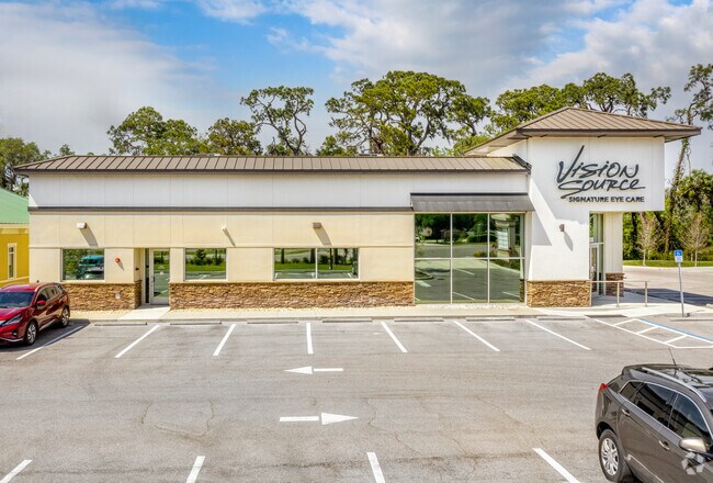
10060 Us Highway 301 N, Parrish, FL 34219

NEARBY LISTINGS FOR SALE OR LEASE
-
-
View all Parrish listings for sale on LoopNet.com
Property Detail
10060 Us Highway 301 N
7264-0105-9
Village Square Land Condominium A Land C
Officecondo
UNIT 1, VILLAGE SQUARE LAND CONDOMINIUM PI #7264.0105/9
X
Manatee
12081C0187F
Florida
2023
0.12 AC
2025
Manatee
001913
Tampa/St Petersburg
5,032 SF
North Port-Bradenton-Sarasota, FL
DEMOGRAPHICS near 10060 Us Highway 301 N
1 Mile
3 Mile
5 Mile
2024 Total Population
6,338
39,878
90,867
2029 Population
7,423
46,787
106,732
Pop Growth 2024-2029
+ 17.12%
+ 17.33%
+ 17.46%
Average Age
46
48
46
2024 Total Households
2,512
16,453
36,270
HH Growth 2024-2029
+ 16.28%
+ 16.55%
+ 16.55%
Median Household Inc
$84,407
$82,056
$81,933
Avg Household Size
2.40
2.40
2.40
2024 Avg HH Vehicles
2.00
2.00
2.00
Median Home Value
$313,168
$292,349
$317,325
Median Year Built
2006
2005
2005
Nearby Places
Map Layers
Map Styles
 Street
 Aerial
- Restaurants
- Banks
- Shops
- Fitness
- Groceries
PUBLIC TRANSPORTATION
AIRPORT
Sarasota/Bradenton International
DRIVE
WALK
Distance
Sarasota/Bradenton International
33 min
17.2 mi
St Pete-Clearwater International
DRIVE
WALK
Distance
St Pete-Clearwater International
52 min
39.6 mi
Tampa International
DRIVE
WALK
Distance
Tampa International
64 min
48.9 mi
Freight Ports
Port Manatee
DRIVE
WALK
Distance
Port Manatee
23 min
12.8 mi
Nearby Properties
Address
Land Use
TOTAL SIZE
Lot Size
Zoning
Address
Land Use
TOTAL SIZE
Lot Size
Zoning
359,241 SF
27.68 AC
PD-MU
Address
Land Use
TOTAL SIZE
Lot Size
Zoning
137.34 AC
Address
Land Use
TOTAL SIZE
Lot Size
Zoning
313,422 SF
47.93 AC
PD-C
Address
Land Use
TOTAL SIZE
Lot Size
Zoning
312,546 SF
39.60 AC
A-1 SUBURB
Address
Land Use
TOTAL SIZE
Lot Size
Zoning
191,100 SF
30.35 AC
PD-C
Address
Land Use
TOTAL SIZE
Lot Size
Zoning
64,800 SF
8.19 AC
Address
Land Use
TOTAL SIZE
Lot Size
Zoning
61,770 SF
79.85 AC
A,A-1
Address
Land Use
TOTAL SIZE
Lot Size
Zoning
66,063 SF
9.24 AC
PD-C
Address
Land Use
TOTAL SIZE
Lot Size
Zoning
158.58 AC
Address
Land Use
TOTAL SIZE
Lot Size
Zoning
43,464 SF
14.47 AC
VIL VILLAG
Address
Land Use
TOTAL SIZE
Lot Size
Zoning
190.90 AC
PD-R
Address
Land Use
TOTAL SIZE
Lot Size
Zoning
59,222 SF
4.49 AC
PD-C
Address
Land Use
TOTAL SIZE
Lot Size
Zoning
43.81 AC
Address
Land Use
TOTAL SIZE
Lot Size
Zoning
56,442 SF
6.18 AC
GC GENERA
Address
Land Use
TOTAL SIZE
Lot Size
Zoning
61,721 SF
5.50 AC
PD-C
Address
Land Use
TOTAL SIZE
Lot Size
Zoning
36,002 SF
4.41 AC
PD-C
Address
Land Use
TOTAL SIZE
Lot Size
Zoning
5,744 SF
12.60 AC
RSMH-6
Address
Land Use
TOTAL SIZE
Lot Size
Zoning
7.86 AC
PD-MU
Address
Land Use
TOTAL SIZE
Lot Size
Zoning
32,860 SF
4.05 AC
PD-O
Address
Land Use
TOTAL SIZE
Lot Size
Zoning
28,413 SF
5.40 AC
RSMH-6
Address
Land Use
TOTAL SIZE
Lot Size
Zoning
1,596 SF
106.35 AC
PD-R
Address
Land Use
TOTAL SIZE
Lot Size
Zoning
53,851 SF
6.32 AC
Address
Land Use
TOTAL SIZE
Lot Size
Zoning
30,101 SF
13.44 AC
PD-C
Address
Land Use
TOTAL SIZE
Lot Size
Zoning
41,168 SF
3.21 AC
PD-C
Address
Land Use
TOTAL SIZE
Lot Size
Zoning
22,855 SF
23.30 AC
PD-R
Address
Land Use
TOTAL SIZE
Lot Size
Zoning
23,742 SF
5.21 AC
A-1 SUBURB
Address
Land Use
TOTAL SIZE
Lot Size
Zoning
36,700 SF
17 AC
A-1 SUBURB
Address
Land Use
TOTAL SIZE
Lot Size
Zoning
44,874 SF
394.53 AC
PD-PI
Address
Land Use
TOTAL SIZE
Lot Size
Zoning
25,912 SF
6.66 AC
PD-C
Address
Land Use
TOTAL SIZE
Lot Size
Zoning
34,830 SF
2.95 AC
GC GENERA
The World's #1 Commercial Real Estate Marketplace
Connect with us
© 2026 CoStar Group
The information above has been obtained from sources believed reliable. While we do not doubt its accuracy we have not verified it and make no guarantee, warranty or representation about it. It is your responsibility to independently confirm its accuracy and completeness. Any projections, opinions, assumptions, or estimates used are for example only and do not represent the current or future performance of the property. The value of this transaction to you depends on tax and other factors which should be evaluated by your tax, financial, and legal advisors. You and your advisors should conduct a careful, independent investigation of the property to determine to your satisfaction the suitability of the property for your needs.