Property Record
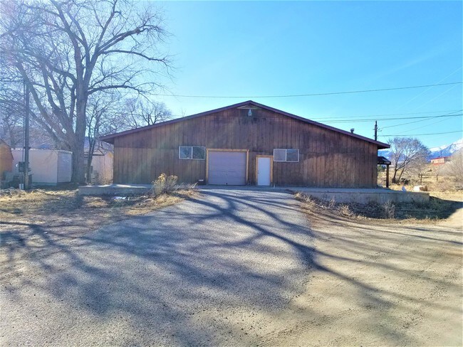
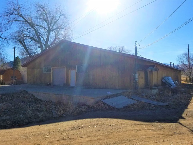
10064 Us Highway 50, Poncha Springs, CO 81242

Property Detail
10064 Us Highway 50
R380510200135
TRACT IN SE4NW4 10-49-8 REC 446827
Commercialnec
CHAFFEE
B and X Area of moderate flood hazard, usually the area between the limits of the 100-year and 500-year floods.
Colorado
2024
4
2025
0.29 AC
000300
Colorado Southwest Area
6,000 SF
Other Market Areas
NEARBY LISTINGS FOR SALE OR LEASE
-
-
View all Poncha Springs listings for sale on LoopNet.com
DEMOGRAPHICS near 10064 Us Highway 50
1 mile
3 mile
5 mile
2025 Total Population
1,045
1,988
9,072
2030 Population
1,113
2,104
9,529
Pop Growth 2025-2030
+ 6.51%
+ 5.84%
+ 5.04%
Average Age
46
46
46
2025 Total Households
489
926
4,289
HH Growth 2025-2030
+ 6.75%
+ 6.05%
+ 5.39%
Median Household Inc
$85,912
$84,745
$76,197
Avg Household Size
2.10
2.10
2.10
2025 Avg HH Vehicles
2.00
2.00
2.00
Median Home Value
$731,481
$733,957
$698,038
Median Year Built
2001
2000
1993
Nearby Places
Map Layers
Map Styles
 Street
 Aerial
Layers
 Traffic
 Biking
Places
Listings with unknown addresses are not visible on the map
- Restaurants
- Banks
- Shops
- Fitness
- Groceries
SALE & LEASE HISTORY
LISTING DATE
SALE/LEASE

Mar 27, 2017
For Sale
Nearby Properties
Address
Land Use
TOTAL SIZE
Lot Size
Zoning
Address
Land Use
TOTAL SIZE
Lot Size
Zoning
109,252 SF
14.06 AC
Address
Land Use
TOTAL SIZE
Lot Size
Zoning
32,100 SF
1.33 AC
Address
Land Use
TOTAL SIZE
Lot Size
Zoning
55,512 SF
4.19 AC
Address
Land Use
TOTAL SIZE
Lot Size
Zoning
35,395 SF
2.96 AC
Address
Land Use
TOTAL SIZE
Lot Size
Zoning
21,700 SF
20 AC
Address
Land Use
TOTAL SIZE
Lot Size
Zoning
54,950 SF
4.15 AC
Address
Land Use
TOTAL SIZE
Lot Size
Zoning
9,660 SF
70.58 AC
Address
Land Use
TOTAL SIZE
Lot Size
Zoning
44,600 SF
10.36 AC
Address
Land Use
TOTAL SIZE
Lot Size
Zoning
3,915 SF
208.75 AC
Address
Land Use
TOTAL SIZE
Lot Size
Zoning
19,520 SF
16.02 AC
Address
Land Use
TOTAL SIZE
Lot Size
Zoning
35,500 SF
6.47 AC
Address
Land Use
TOTAL SIZE
Lot Size
Zoning
10,572 SF
2.36 AC
Address
Land Use
TOTAL SIZE
Lot Size
Zoning
26,080 SF
1.91 AC
Address
Land Use
TOTAL SIZE
Lot Size
Zoning
8,000 SF
0.56 AC
Address
Land Use
TOTAL SIZE
Lot Size
Zoning
31,200 SF
1.74 AC
Address
Land Use
TOTAL SIZE
Lot Size
Zoning
120 SF
59.52 AC
Address
Land Use
TOTAL SIZE
Lot Size
Zoning
17,060 SF
3.27 AC
Address
Land Use
TOTAL SIZE
Lot Size
Zoning
6,000 SF
1.02 AC
Address
Land Use
TOTAL SIZE
Lot Size
Zoning
15,000 SF
2.07 AC
Address
Land Use
TOTAL SIZE
Lot Size
Zoning
8,848 SF
3.35 AC
Address
Land Use
TOTAL SIZE
Lot Size
Zoning
9,081 SF
7.84 AC
Address
Land Use
TOTAL SIZE
Lot Size
Zoning
24,000 SF
3.36 AC
Address
Land Use
TOTAL SIZE
Lot Size
Zoning
12,400 SF
2.60 AC
Address
Land Use
TOTAL SIZE
Lot Size
Zoning
1,573 SF
0.95 AC
Address
Land Use
TOTAL SIZE
Lot Size
Zoning
3,484 SF
185 AC
Address
Land Use
TOTAL SIZE
Lot Size
Zoning
13,102 SF
1.42 AC
Address
Land Use
TOTAL SIZE
Lot Size
Zoning
1,107 SF
0.89 AC
Address
Land Use
TOTAL SIZE
Lot Size
Zoning
9,671 SF
2.30 AC
Address
Land Use
TOTAL SIZE
Lot Size
Zoning
21,104 SF
1.15 AC
Address
Land Use
TOTAL SIZE
Lot Size
Zoning
5,578 SF
1 AC
The World's #1 Commercial Real Estate Marketplace
Connect with us
© 2026 CoStar Group
The information above has been obtained from sources believed reliable. While we do not doubt its accuracy we have not verified it and make no guarantee, warranty or representation about it. It is your responsibility to independently confirm its accuracy and completeness. Any projections, opinions, assumptions, or estimates used are for example only and do not represent the current or future performance of the property. The value of this transaction to you depends on tax and other factors which should be evaluated by your tax, financial, and legal advisors. You and your advisors should conduct a careful, independent investigation of the property to determine to your satisfaction the suitability of the property for your needs.