Property Record
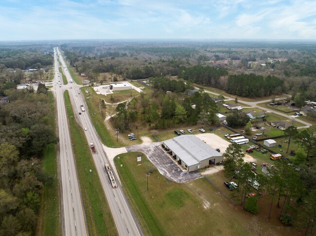
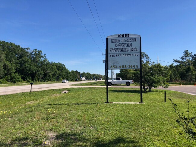
10065 Us Highway 301, Hampton, FL 32044


Property Detail
10065 Us Highway 301
00972-0-00500
25 7S 21 COM SW COR OF N1/2 OF NE1/4. N88*3708E 459.24 TO E R/W SR200 & POB. N8*4911E 589.59 S81*1049E 300, S08*4911W 535.57, S88*3629W 304.83 TO POB. BEING 3.87 ACRES
Vehiclerentalsvehiclesales
Bradford
B and X Area of moderate flood hazard, usually the area between the limits of the 100-year and 500-year floods.
Florida
2025
3.87 AC
2025
Florida Central North Area
000302
Other Market Areas
12,000 SF
NEARBY LISTINGS FOR SALE OR LEASE
-
-
View all Hampton listings for lease on LoopNet.com
DEMOGRAPHICS near 10065 Us Highway 301
1 mile
3 mile
5 mile
2025 Total Population
785
2,471
5,001
2030 Population
841
2,642
5,325
Pop Growth 2025-2030
+ 7.13%
+ 6.92%
+ 6.48%
Average Age
42
42
42
2025 Total Households
302
952
1,958
HH Growth 2025-2030
+ 5.96%
+ 5.88%
+ 5.67%
Median Household Inc
$49,952
$53,222
$49,999
Avg Household Size
2.60
2.60
2.50
2025 Avg HH Vehicles
2.00
2.00
2.00
Median Home Value
$214,516
$179,040
$166,200
Median Year Built
1986
1987
1985
Nearby Places
Map Layers
Map Styles
 Street
 Aerial
Layers
 Traffic
 Biking
Places
Listings with unknown addresses are not visible on the map
- Restaurants
- Banks
- Shops
- Fitness
- Groceries
PUBLIC TRANSPORTATION
AIRPORT
Gainesville Regional
Drive
Walk
Distance
Gainesville Regional
27 min
17.5 mi
Freight Ports
Jacksonville Port
Drive
Walk
Distance
Jacksonville Port
71 min
55.9 mi
SALE & LEASE HISTORY
LISTING DATE
SALE/LEASE

May 07, 2021
For Lease
May 07, 2021
For Sale
Feb 27, 2019
For Sale
Feb 21, 2020
For Sale
Dec 13, 2018
For Lease
Dec 13, 2018
For Sale
Nearby Properties
Address
Land Use
TOTAL SIZE
Lot Size
Zoning
Address
Land Use
TOTAL SIZE
Lot Size
Zoning
14,776 SF
73.70 AC
Address
Land Use
TOTAL SIZE
Lot Size
Zoning
44,809 SF
40 AC
Address
Land Use
TOTAL SIZE
Lot Size
Zoning
37,070 SF
10 AC
Address
Land Use
TOTAL SIZE
Lot Size
Zoning
10,490 SF
206.67 AC
Address
Land Use
TOTAL SIZE
Lot Size
Zoning
9,790 SF
13.99 AC
Address
Land Use
TOTAL SIZE
Lot Size
Zoning
8,373 SF
9.62 AC
Address
Land Use
TOTAL SIZE
Lot Size
Zoning
13,916 SF
5.89 AC
Address
Land Use
TOTAL SIZE
Lot Size
Zoning
7,343 SF
1.99 AC
Address
Land Use
TOTAL SIZE
Lot Size
Zoning
22,047 SF
2.12 AC
Address
Land Use
TOTAL SIZE
Lot Size
Zoning
3,908 SF
10.25 AC
Address
Land Use
TOTAL SIZE
Lot Size
Zoning
12,531 SF
11.25 AC
Address
Land Use
TOTAL SIZE
Lot Size
Zoning
32.13 AC
Address
Land Use
TOTAL SIZE
Lot Size
Zoning
5,718 SF
10.79 AC
Address
Land Use
TOTAL SIZE
Lot Size
Zoning
14.65 AC
Address
Land Use
TOTAL SIZE
Lot Size
Zoning
2,647 SF
5.98 AC
Address
Land Use
TOTAL SIZE
Lot Size
Zoning
5,050 SF
9.90 AC
Address
Land Use
TOTAL SIZE
Lot Size
Zoning
19.18 AC
Address
Land Use
TOTAL SIZE
Lot Size
Zoning
2,152 SF
12.94 AC
Address
Land Use
TOTAL SIZE
Lot Size
Zoning
4,648 SF
95 AC
Address
Land Use
TOTAL SIZE
Lot Size
Zoning
5,228 SF
77.28 AC
Address
Land Use
TOTAL SIZE
Lot Size
Zoning
139.70 AC
Address
Land Use
TOTAL SIZE
Lot Size
Zoning
3,948 SF
9.22 AC
Address
Land Use
TOTAL SIZE
Lot Size
Zoning
Address
Land Use
TOTAL SIZE
Lot Size
Zoning
6,086 SF
77.01 AC
Address
Land Use
TOTAL SIZE
Lot Size
Zoning
6,374 SF
119 AC
Address
Land Use
TOTAL SIZE
Lot Size
Zoning
56.28 AC
Address
Land Use
TOTAL SIZE
Lot Size
Zoning
6,130 SF
52.49 AC
Address
Land Use
TOTAL SIZE
Lot Size
Zoning
6,809 SF
9.53 AC
Address
Land Use
TOTAL SIZE
Lot Size
Zoning
21,693 SF
9.20 AC
The World's #1 Commercial Real Estate Marketplace
Connect with us
© 2026 CoStar Group
The information above has been obtained from sources believed reliable. While we do not doubt its accuracy we have not verified it and make no guarantee, warranty or representation about it. It is your responsibility to independently confirm its accuracy and completeness. Any projections, opinions, assumptions, or estimates used are for example only and do not represent the current or future performance of the property. The value of this transaction to you depends on tax and other factors which should be evaluated by your tax, financial, and legal advisors. You and your advisors should conduct a careful, independent investigation of the property to determine to your satisfaction the suitability of the property for your needs.