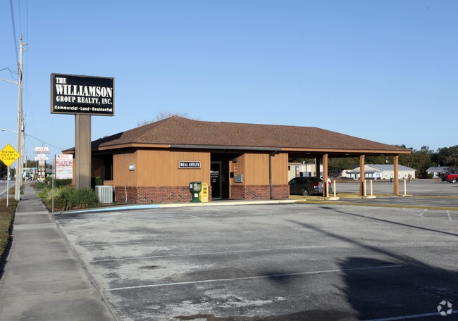
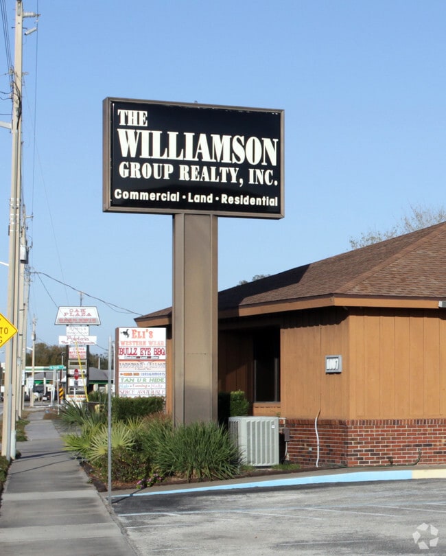
Property Record
1007 E Oak St, Arcadia, FL 34266

Property Detail
1007 E Oak St
31-37-25-0016-1070-0011
A W GILCHRIST EAST END ADD BEG AT INT OF E LINE BLK 7 TIER 1 & NELY R/W LINE SR 70 FOR POB TH N68D52M14S W ALG SD R/W 192 FT TH N 18D04M25S E 61.90 FT TH S 83D13M36S E 161 FT TO E LI SD BLK 7 TIER 1 TH S 0D00M10S E 109.07 FT TO POB INST:201214005151
Officebuilding
Desoto
B-3
Florida
B and X Area of moderate flood hazard, usually the area between the limits of the 100-year and 500-year floods.
1-6,8
2024
0.34 AC
2024
Florida Central South Area
010302
Other Market Areas
2,014 SF
Arcadia, FL
NEARBY LISTINGS FOR SALE OR LEASE
-
-
View all Arcadia listings for sale on LoopNet.com
DEMOGRAPHICS near 1007 E Oak St
1 mile
3 mile
5 mile
2025 Total Population
7,710
18,612
23,642
2030 Population
8,258
19,959
25,272
Pop Growth 2025-2030
+ 7.11%
+ 7.24%
+ 6.89%
Average Age
36
39
40
2025 Total Households
2,557
6,423
8,065
HH Growth 2025-2030
+ 7.63%
+ 7.85%
+ 7.48%
Median Household Inc
$43,472
$46,824
$47,602
Avg Household Size
2.90
2.70
2.70
2025 Avg HH Vehicles
2.00
2.00
2.00
Median Home Value
$167,201
$152,105
$162,633
Median Year Built
1976
1981
1984
Nearby Places
Map Layers
Map Styles
 Street
 Aerial
Transit
 Traffic
 Biking
Places
Listings with unknown addresses are not visible on the map
- Restaurants
- Banks
- Shops
- Fitness
- Groceries
PUBLIC TRANSPORTATION
AIRPORT
Punta Gorda
Drive
Walk
Distance
Punta Gorda
39 min
26.1 mi
Nearby Properties
Address
Land Use
TOTAL SIZE
Lot Size
Zoning
Address
Land Use
TOTAL SIZE
Lot Size
Zoning
67,387 SF
46.10 AC
PUD
Address
Land Use
TOTAL SIZE
Lot Size
Zoning
106,179 SF
12.48 AC
RPB
Address
Land Use
TOTAL SIZE
Lot Size
Zoning
182,809 SF
60 AC
A-5
Address
Land Use
TOTAL SIZE
Lot Size
Zoning
128,748 SF
21.47 AC
CG
Address
Land Use
TOTAL SIZE
Lot Size
Zoning
57,048 SF
20.25 AC
PUD
Address
Land Use
TOTAL SIZE
Lot Size
Zoning
7,911 SF
30 AC
TTRVC
Address
Land Use
TOTAL SIZE
Lot Size
Zoning
106,061 SF
15 AC
P/I
Address
Land Use
TOTAL SIZE
Lot Size
Zoning
11,316 SF
43.64 AC
TTRVC
Address
Land Use
TOTAL SIZE
Lot Size
Zoning
67,970 SF
8.24 AC
CG
Address
Land Use
TOTAL SIZE
Lot Size
Zoning
121,889 SF
9 AC
B-3
Address
Land Use
TOTAL SIZE
Lot Size
Zoning
67,407 SF
4.82 AC
R-1B
Address
Land Use
TOTAL SIZE
Lot Size
Zoning
25,798 SF
5 AC
B-1A
Address
Land Use
TOTAL SIZE
Lot Size
Zoning
39,416 SF
2.29 AC
CG
Address
Land Use
TOTAL SIZE
Lot Size
Zoning
76,468 SF
40 AC
P/I
Address
Land Use
TOTAL SIZE
Lot Size
Zoning
80,103 SF
11 AC
R-1B
Address
Land Use
TOTAL SIZE
Lot Size
Zoning
23,512 SF
120 AC
MHP
Address
Land Use
TOTAL SIZE
Lot Size
Zoning
32,546 SF
45.40 AC
P/I
Address
Land Use
TOTAL SIZE
Lot Size
Zoning
53,740 SF
2.29 AC
R-1B
Address
Land Use
TOTAL SIZE
Lot Size
Zoning
45,985 SF
1.30 AC
B-2
Address
Land Use
TOTAL SIZE
Lot Size
Zoning
7,101 SF
30.89 AC
MHP
Address
Land Use
TOTAL SIZE
Lot Size
Zoning
40,614 SF
4.33 AC
R-3
Address
Land Use
TOTAL SIZE
Lot Size
Zoning
41,004 SF
4.67 AC
R-3
Address
Land Use
TOTAL SIZE
Lot Size
Zoning
7,308 SF
48 AC
TTRVC
Address
Land Use
TOTAL SIZE
Lot Size
Zoning
54,644 SF
11.82 AC
PUD
Address
Land Use
TOTAL SIZE
Lot Size
Zoning
33.75 AC
PUD
Address
Land Use
TOTAL SIZE
Lot Size
Zoning
27,816 SF
3.67 AC
RMF-8
Address
Land Use
TOTAL SIZE
Lot Size
Zoning
48,488 SF
3.24 AC
B-2
Address
Land Use
TOTAL SIZE
Lot Size
Zoning
97,755 SF
9.20 AC
PUD
Address
Land Use
TOTAL SIZE
Lot Size
Zoning
21,108 SF
3.36 AC
A-5
Address
Land Use
TOTAL SIZE
Lot Size
Zoning
20,008 SF
4.69 AC
A-5
The World's #1 Commercial Real Estate Marketplace
Connect with us
© 2026 CoStar Group
The information above has been obtained from sources believed reliable. While we do not doubt its accuracy we have not verified it and make no guarantee, warranty or representation about it. It is your responsibility to independently confirm its accuracy and completeness. Any projections, opinions, assumptions, or estimates used are for example only and do not represent the current or future performance of the property. The value of this transaction to you depends on tax and other factors which should be evaluated by your tax, financial, and legal advisors. You and your advisors should conduct a careful, independent investigation of the property to determine to your satisfaction the suitability of the property for your needs.