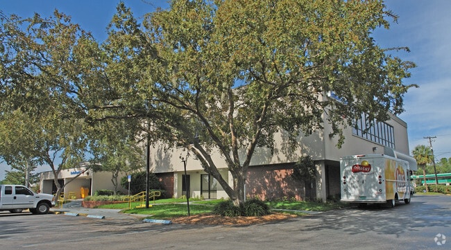
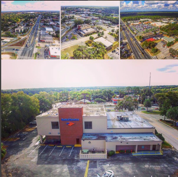
Property Record
1007 W Main St, Inverness, FL 34450
NEARBY LISTINGS FOR SALE OR LEASE
Property Detail
1007 W Main St
Homosassa Springs, FL
Unrec Tracts In 18-19S-20E
20E-19S-18-0000-24400
DISTRICT SERVICE CENTER: COM AT THE NE COR OF LOT 1 LEE VILLA PB 2 PG 8 TH N 0D 22M 31S W AL A N PROJECTION OF THE E BDRY LN OF LT 1 SD E BDRY ALSO BEING THE W R/W LN OF S LINE AVE A DIST OF 116.57 FT TO AN UNNUMBERED 1/2 IN ROD SD PT BEING THE INTER
Publicschool
Citrus
AE
Florida
12017C0354D
1
2024
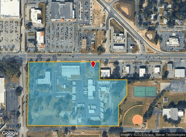
16.38 AC
2025
Florida Central North Area
451400
Other Market Areas
72,780 SF
DEMOGRAPHICS near 1007 W Main St
1 Mile
3 Mile
5 Mile
2024 Total Population
2,782
19,636
35,083
2029 Population
3,173
22,249
39,754
Pop Growth 2024-2029
+ 14.05%
+ 13.31%
+ 13.31%
Average Age
50
48
49
2024 Total Households
1,286
8,761
15,785
HH Growth 2024-2029
+ 14.07%
+ 13.15%
+ 13.11%
Median Household Inc
$39,191
$38,935
$41,086
Avg Household Size
2.00
2.10
2.10
2024 Avg HH Vehicles
1.00
2.00
2.00
Median Home Value
$208,525
$164,134
$169,576
Median Year Built
1985
1984
1984
Nearby Places
Map Layers
Map Styles
 Street
 Aerial
- Restaurants
- Banks
- Shops
- Fitness
- Groceries
SALE & LEASE HISTORY
LISTING DATE
SALE/LEASE

Jan 31, 2017
For Lease
Nearby Properties
Address
Land Use
TOTAL SIZE
Lot Size
Zoning
Address
Land Use
TOTAL SIZE
Lot Size
Zoning
7,138,137 SF
12.68 AC
PSP
Address
Land Use
TOTAL SIZE
Lot Size
Zoning
151,398 SF
51.27 AC
PSP
Address
Land Use
TOTAL SIZE
Lot Size
Zoning
40,730 SF
35.79 AC
PSP
Address
Land Use
TOTAL SIZE
Lot Size
Zoning
103,592 SF
1.12 AC
CBD
Address
Land Use
TOTAL SIZE
Lot Size
Zoning
49,206 SF
0.56 AC
CBD
Address
Land Use
TOTAL SIZE
Lot Size
Zoning
139,076 SF
8.12 AC
C
Address
Land Use
TOTAL SIZE
Lot Size
Zoning
89,638 SF
21.78 AC
PSP
Address
Land Use
TOTAL SIZE
Lot Size
Zoning
106,366 SF
45.53 AC
PSP
Address
Land Use
TOTAL SIZE
Lot Size
Zoning
32,920 SF
20.03 AC
PSP
Address
Land Use
TOTAL SIZE
Lot Size
Zoning
83,966 SF
29.08 AC
PSP
Address
Land Use
TOTAL SIZE
Lot Size
Zoning
2,251,312 SF
13.80 AC
C
Address
Land Use
TOTAL SIZE
Lot Size
Zoning
162,123 SF
10.82 AC
C
Address
Land Use
TOTAL SIZE
Lot Size
Zoning
53,746 SF
13.98 AC
PSP
Address
Land Use
TOTAL SIZE
Lot Size
Zoning
155,103 SF
3.90 AC
PSP
Address
Land Use
TOTAL SIZE
Lot Size
Zoning
146,480 SF
2.27 AC
CBD
Address
Land Use
TOTAL SIZE
Lot Size
Zoning
61,778 SF
1.55 AC
CBD
Address
Land Use
TOTAL SIZE
Lot Size
Zoning
157,116 SF
4.37 AC
PSP
Address
Land Use
TOTAL SIZE
Lot Size
Zoning
44,260 SF
3.92 AC
RO
Address
Land Use
TOTAL SIZE
Lot Size
Zoning
91,826 SF
19.74 AC
RO
Address
Land Use
TOTAL SIZE
Lot Size
Zoning
142,544 SF
19.69 AC
LDRMH
Address
Land Use
TOTAL SIZE
Lot Size
Zoning
26,391 SF
5.06 AC
LD
Address
Land Use
TOTAL SIZE
Lot Size
Zoning
68,720 SF
1.01 AC
CBD
Address
Land Use
TOTAL SIZE
Lot Size
Zoning
37,800 SF
5.15 AC
PSP
Address
Land Use
TOTAL SIZE
Lot Size
Zoning
16,448 SF
1.61 AC
CBD
Address
Land Use
TOTAL SIZE
Lot Size
Zoning
31,322 SF
7.35 AC
ULD
Address
Land Use
TOTAL SIZE
Lot Size
Zoning
71,113 SF
4.51 AC
C
Address
Land Use
TOTAL SIZE
Lot Size
Zoning
92,137 SF
4.83 AC
GNC
Address
Land Use
TOTAL SIZE
Lot Size
Zoning
22,316 SF
1.10 AC
CBD
Address
Land Use
TOTAL SIZE
Lot Size
Zoning
12,632 SF
1.76 AC
C
The World's #1 Commercial Real Estate Marketplace
Connect with us
© 2025 CoStar Group
The information above has been obtained from sources believed reliable. While we do not doubt its accuracy we have not verified it and make no guarantee, warranty or representation about it. It is your responsibility to independently confirm its accuracy and completeness. Any projections, opinions, assumptions, or estimates used are for example only and do not represent the current or future performance of the property. The value of this transaction to you depends on tax and other factors which should be evaluated by your tax, financial, and legal advisors. You and your advisors should conduct a careful, independent investigation of the property to determine to your satisfaction the suitability of the property for your needs.