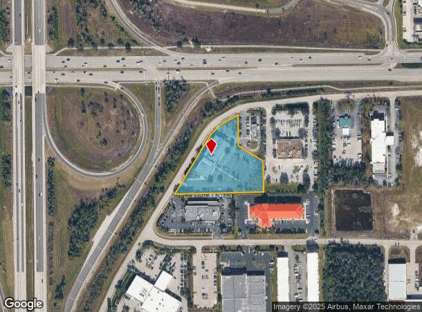
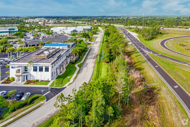
Property Record
10070 Daniels Interstate Ct, Fort Myers, FL 33913


Current Lease Availabilities
NEARBY LISTINGS FOR SALE OR LEASE
Property Detail
10070 Daniels Interstate Ct
22-45-25-20-00013.0010
E. Daniels Rd / Airport
Officebuilding
TRACT 13 D75 COMMERCE CENTER REPLAT DESC IN INST#2008000127652 TRACT 13-1
X
Lee
12071C0445F
Florida
2024
2.31 AC
2025
S Ft Myers/San Carlos
040138
Southwest Florida
29,787 SF
Cape Coral-Fort Myers, FL
DEMOGRAPHICS near 10070 Daniels Interstate Ct
1 Mile
3 Mile
5 Mile
2024 Total Population
1,519
27,887
89,054
2029 Population
1,882
33,507
106,517
Pop Growth 2024-2029
+ 23.90%
+ 20.15%
+ 19.61%
Average Age
60
54
47
2024 Total Households
760
13,084
38,856
HH Growth 2024-2029
+ 23.82%
+ 19.99%
+ 19.44%
Median Household Inc
$97,868
$87,430
$79,094
Avg Household Size
2.00
2.10
2.20
2024 Avg HH Vehicles
2.00
2.00
2.00
Median Home Value
$545,699
$353,646
$324,771
Median Year Built
2010
2005
2003
Nearby Places
Map Layers
Map Styles
 Street
 Aerial
- Restaurants
- Banks
- Shops
- Fitness
- Groceries
PUBLIC TRANSPORTATION
AIRPORT
Southwest Florida International
DRIVE
WALK
Distance
Southwest Florida International
8 min
3.3 mi
Punta Gorda
DRIVE
WALK
Distance
Punta Gorda
39 min
32.2 mi
Freight Ports
Port Manatee
DRIVE
WALK
Distance
Port Manatee
119 min
103.9 mi
Nearby Properties
Address
Land Use
TOTAL SIZE
Lot Size
Zoning
Address
Land Use
TOTAL SIZE
Lot Size
Zoning
545,043 SF
16.29 AC
C-1
Address
Land Use
TOTAL SIZE
Lot Size
Zoning
21.08 AC
MDP-3
Address
Land Use
TOTAL SIZE
Lot Size
Zoning
311,796 SF
32.56 AC
IL
Address
Land Use
TOTAL SIZE
Lot Size
Zoning
15.08 AC
Address
Land Use
TOTAL SIZE
Lot Size
Zoning
246,785 SF
18.54 AC
AOPD
Address
Land Use
TOTAL SIZE
Lot Size
Zoning
25.16 AC
RPD
Address
Land Use
TOTAL SIZE
Lot Size
Zoning
158,775 SF
13.72 AC
MPD
Address
Land Use
TOTAL SIZE
Lot Size
Zoning
315,233 SF
75.18 AC
CPD
Address
Land Use
TOTAL SIZE
Lot Size
Zoning
134,369 SF
8.31 AC
PUD
Address
Land Use
TOTAL SIZE
Lot Size
Zoning
33.21 AC
AG-2
Address
Land Use
TOTAL SIZE
Lot Size
Zoning
130,970 SF
8.68 AC
PUD
Address
Land Use
TOTAL SIZE
Lot Size
Zoning
204,456 SF
5.21 AC
C-1
Address
Land Use
TOTAL SIZE
Lot Size
Zoning
213,556 SF
18.17 AC
CPD
Address
Land Use
TOTAL SIZE
Lot Size
Zoning
10.16 AC
MDP-3
Address
Land Use
TOTAL SIZE
Lot Size
Zoning
105,332 SF
11.08 AC
PUD
Address
Land Use
TOTAL SIZE
Lot Size
Zoning
10.50 AC
AG-2
Address
Land Use
TOTAL SIZE
Lot Size
Zoning
Address
Land Use
TOTAL SIZE
Lot Size
Zoning
96,408 SF
5.75 AC
PUD
Address
Land Use
TOTAL SIZE
Lot Size
Zoning
68,185 SF
29.25 AC
CFPD
Address
Land Use
TOTAL SIZE
Lot Size
Zoning
221,486 SF
74.60 AC
PUD
Address
Land Use
TOTAL SIZE
Lot Size
Zoning
93,453 SF
9.66 AC
CPD
Address
Land Use
TOTAL SIZE
Lot Size
Zoning
7.78 AC
MPD
Address
Land Use
TOTAL SIZE
Lot Size
Zoning
119.70 AC
MPD
Address
Land Use
TOTAL SIZE
Lot Size
Zoning
154.54 AC
MPD
Address
Land Use
TOTAL SIZE
Lot Size
Zoning
73,681 SF
3.46 AC
MPD
Address
Land Use
TOTAL SIZE
Lot Size
Zoning
53,472 SF
75 AC
AG-2
Address
Land Use
TOTAL SIZE
Lot Size
Zoning
63,900 SF
4.18 AC
CT
Address
Land Use
TOTAL SIZE
Lot Size
Zoning
58,098 SF
2.75 AC
CPD
Address
Land Use
TOTAL SIZE
Lot Size
Zoning
185,360 SF
9.90 AC
PUD
Address
Land Use
TOTAL SIZE
Lot Size
Zoning
51,128 SF
36.27 AC
CPD
The World's #1 Commercial Real Estate Marketplace
Connect with us
© 2026 CoStar Group
The information above has been obtained from sources believed reliable. While we do not doubt its accuracy we have not verified it and make no guarantee, warranty or representation about it. It is your responsibility to independently confirm its accuracy and completeness. Any projections, opinions, assumptions, or estimates used are for example only and do not represent the current or future performance of the property. The value of this transaction to you depends on tax and other factors which should be evaluated by your tax, financial, and legal advisors. You and your advisors should conduct a careful, independent investigation of the property to determine to your satisfaction the suitability of the property for your needs.