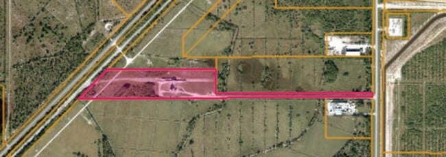
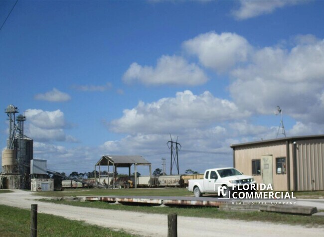
Property Record
10075 Range Line Rd, Fort Pierce, FL 34950
NEARBY LISTINGS FOR SALE OR LEASE
Property Detail
10075 Range Line Rd
Port St Lucie, FL
Metes And Bounds
42-01-132-0001-0002
St Lucie
Lightindustrial
Florida
X
18.79 AC
12111C0275J
St Lucie Inland
5,675 SF
Port St Lucie/Fort Pierce
DEMOGRAPHICS near 10075 Range Line Rd
1 Mile
3 Mile
5 Mile
2024 Total Population
3
5,982
32,047
2029 Population
4
7,580
39,977
Pop Growth 2024-2029
+ 33.33%
+ 26.71%
+ 24.74%
Average Age
0
55
50
2024 Total Households
1
2,689
13,407
HH Growth 2024-2029
0.00%
+ 26.26%
+ 24.49%
Median Household Inc
$0
$73,809
$72,740
Avg Household Size
.00
2.20
2.30
2024 Avg HH Vehicles
.00
2.00
2.00
Median Home Value
$0
$348,942
$336,195
Median Year Built
2011
2011
2010
Nearby Places
Map Layers
Map Styles
 Street
 Aerial
- Restaurants
- Banks
- Shops
- Fitness
- Groceries
SALE & LEASE HISTORY
LISTING DATE
SALE/LEASE

Jun 01, 2023
For Sale
Nearby Properties
Address
Land Use
TOTAL SIZE
Lot Size
Zoning
Address
Land Use
TOTAL SIZE
Lot Size
Zoning
205,792 SF
29.99 AC
MASTER PLA
Address
Land Use
TOTAL SIZE
Lot Size
Zoning
106,211 SF
28.51 AC
MASTER PLA
Address
Land Use
TOTAL SIZE
Lot Size
Zoning
153,030 SF
15.73 AC
PUD
Address
Land Use
TOTAL SIZE
Lot Size
Zoning
553.20 AC
PUD
Address
Land Use
TOTAL SIZE
Lot Size
Zoning
33,438 SF
8.08 AC
MASTER PLA
Address
Land Use
TOTAL SIZE
Lot Size
Zoning
6,482 SF
83.99 AC
PUD
Address
Land Use
TOTAL SIZE
Lot Size
Zoning
45,215 SF
10.42 AC
MASTER PLA
Address
Land Use
TOTAL SIZE
Lot Size
Zoning
49.11 AC
INSTITUTIO
Address
Land Use
TOTAL SIZE
Lot Size
Zoning
40.82 AC
Address
Land Use
TOTAL SIZE
Lot Size
Zoning
50,690 SF
17.71 AC
INDUST HEA
Address
Land Use
TOTAL SIZE
Lot Size
Zoning
69.83 AC
PUD
Address
Land Use
TOTAL SIZE
Lot Size
Zoning
71.32 AC
MASTER PLA
Address
Land Use
TOTAL SIZE
Lot Size
Zoning
9,545 SF
14.57 AC
PUD
Address
Land Use
TOTAL SIZE
Lot Size
Zoning
124.69 AC
MASTER PLA
Address
Land Use
TOTAL SIZE
Lot Size
Zoning
43,606 SF
24.38 AC
INDUST HEA
Address
Land Use
TOTAL SIZE
Lot Size
Zoning
23.04 AC
MASTER PLA
Address
Land Use
TOTAL SIZE
Lot Size
Zoning
33.81 AC
MASTER PLA
Address
Land Use
TOTAL SIZE
Lot Size
Zoning
6,505 SF
2.25 AC
MASTER PLA
Address
Land Use
TOTAL SIZE
Lot Size
Zoning
12,863 SF
8.79 AC
INDUST HEA
Address
Land Use
TOTAL SIZE
Lot Size
Zoning
11.49 AC
MASTER PLA
Address
Land Use
TOTAL SIZE
Lot Size
Zoning
15,243 SF
8.43 AC
INDUST HEA
Address
Land Use
TOTAL SIZE
Lot Size
Zoning
9.38 AC
MASTER PLA
Address
Land Use
TOTAL SIZE
Lot Size
Zoning
44 AC
MASTER PLA
Address
Land Use
TOTAL SIZE
Lot Size
Zoning
10.71 AC
PUD
Address
Land Use
TOTAL SIZE
Lot Size
Zoning
9,684 SF
6.85 AC
INDUST HEA
Address
Land Use
TOTAL SIZE
Lot Size
Zoning
2.40 AC
MASTER PLA
Address
Land Use
TOTAL SIZE
Lot Size
Zoning
10 AC
INDUST HEA
Address
Land Use
TOTAL SIZE
Lot Size
Zoning
10,717 SF
26.96 AC
MASTER PLA
Address
Land Use
TOTAL SIZE
Lot Size
Zoning
3,445 SF
4.92 AC
INDUST HEA
Address
Land Use
TOTAL SIZE
Lot Size
Zoning
45.22 AC
AG-5 COUNT
The World's #1 Commercial Real Estate Marketplace
Connect with us
© 2025 CoStar Group
The information above has been obtained from sources believed reliable. While we do not doubt its accuracy we have not verified it and make no guarantee, warranty or representation about it. It is your responsibility to independently confirm its accuracy and completeness. Any projections, opinions, assumptions, or estimates used are for example only and do not represent the current or future performance of the property. The value of this transaction to you depends on tax and other factors which should be evaluated by your tax, financial, and legal advisors. You and your advisors should conduct a careful, independent investigation of the property to determine to your satisfaction the suitability of the property for your needs.