Property Record
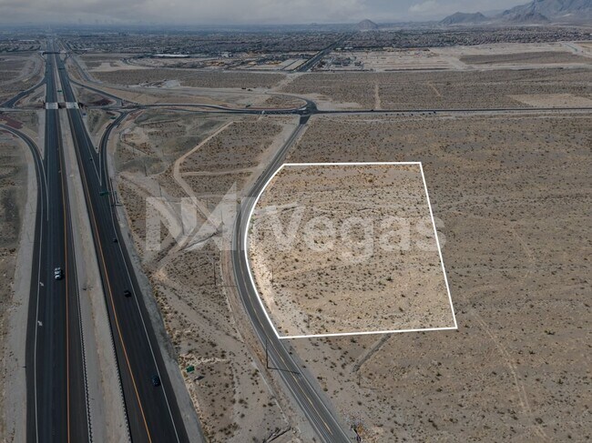
10077 Ruston Rd, Las Vegas, NV 89166


Property Detail
10077 Ruston Rd
126-01-601-015
PT SE4 NE4 SEC 01 19 59
Vacantlandnec
CLARK
H2
Nevada
B and X Area of moderate flood hazard, usually the area between the limits of the 100-year and 500-year floods.
3.99 AC
2026
Northwest Las Vegas
2026
Las Vegas
003265
Las Vegas-Henderson-North Las Vegas, NV
NEARBY LISTINGS FOR SALE OR LEASE
DEMOGRAPHICS near 10077 Ruston Rd
1 mile
3 mile
5 mile
2025 Total Population
5,069
63,190
112,835
2030 Population
5,804
67,429
120,097
Pop Growth 2025-2030
+ 14.50%
+ 6.71%
+ 6.44%
Average Age
36
36
38
2025 Total Households
1,631
21,353
39,229
HH Growth 2025-2030
+ 14.47%
+ 6.70%
+ 6.47%
Median Household Inc
$106,494
$104,191
$105,965
Avg Household Size
3.10
2.90
2.80
2025 Avg HH Vehicles
2.00
2.00
2.00
Median Home Value
$623,774
$504,427
$511,730
Median Year Built
2011
2008
2007
Nearby Places
Map Layers
Map Styles
 Street
 Aerial
Transit
 Traffic
 Biking
Places
Listings with unknown addresses are not visible on the map
- Restaurants
- Banks
- Shops
- Fitness
- Groceries
PUBLIC TRANSPORTATION
AIRPORT
Harry Reid International
Drive
Walk
Distance
Harry Reid International
35 min
23.8 mi
Freight Ports
Port of Long Beach
Drive
Walk
Distance
Port of Long Beach
336 min
299.3 mi
SALE & LEASE HISTORY
LISTING DATE
SALE/LEASE

Jan 25, 2022
For Sale
Aug 13, 2021
For Sale
Nearby Properties
Address
Land Use
TOTAL SIZE
Lot Size
Zoning
Address
Land Use
TOTAL SIZE
Lot Size
Zoning
27,487 SF
697.78 AC
CV
Address
Land Use
TOTAL SIZE
Lot Size
Zoning
20,943 SF
17.99 AC
PD
Address
Land Use
TOTAL SIZE
Lot Size
Zoning
704 SF
7.49 AC
Address
Land Use
TOTAL SIZE
Lot Size
Zoning
9,415 SF
12.63 AC
Address
Land Use
TOTAL SIZE
Lot Size
Zoning
14.92 AC
UPROS
Address
Land Use
TOTAL SIZE
Lot Size
Zoning
12.42 AC
PF
Address
Land Use
TOTAL SIZE
Lot Size
Zoning
63,946 SF
10.30 AC
TC
Address
Land Use
TOTAL SIZE
Lot Size
Zoning
125,676 SF
11.98 AC
Address
Land Use
TOTAL SIZE
Lot Size
Zoning
72,654 SF
9.50 AC
Address
Land Use
TOTAL SIZE
Lot Size
Zoning
81.16 AC
Address
Land Use
TOTAL SIZE
Lot Size
Zoning
56,090 SF
5.48 AC
Address
Land Use
TOTAL SIZE
Lot Size
Zoning
Address
Land Use
TOTAL SIZE
Lot Size
Zoning
119,964 SF
11.23 AC
TC
Address
Land Use
TOTAL SIZE
Lot Size
Zoning
32,579 SF
5.70 AC
Address
Land Use
TOTAL SIZE
Lot Size
Zoning
Address
Land Use
TOTAL SIZE
Lot Size
Zoning
65,165 SF
7.58 AC
TC
Address
Land Use
TOTAL SIZE
Lot Size
Zoning
32,988 SF
3.85 AC
Address
Land Use
TOTAL SIZE
Lot Size
Zoning
32.40 AC
CV
Address
Land Use
TOTAL SIZE
Lot Size
Zoning
103,539 SF
2.79 AC
Address
Land Use
TOTAL SIZE
Lot Size
Zoning
29.50 AC
PD
Address
Land Use
TOTAL SIZE
Lot Size
Zoning
101,700 SF
2.94 AC
C1
Address
Land Use
TOTAL SIZE
Lot Size
Zoning
31.58 AC
Address
Land Use
TOTAL SIZE
Lot Size
Zoning
10,686 SF
2.57 AC
Address
Land Use
TOTAL SIZE
Lot Size
Zoning
20.69 AC
PD
Address
Land Use
TOTAL SIZE
Lot Size
Zoning
11,707 SF
2.71 AC
C1
Address
Land Use
TOTAL SIZE
Lot Size
Zoning
Address
Land Use
TOTAL SIZE
Lot Size
Zoning
90,552 SF
2.28 AC
TC
Address
Land Use
TOTAL SIZE
Lot Size
Zoning
19,825 SF
2.82 AC
Address
Land Use
TOTAL SIZE
Lot Size
Zoning
22,092 SF
2.30 AC
The World's #1 Commercial Real Estate Marketplace
Connect with us
© 2026 CoStar Group
The information above has been obtained from sources believed reliable. While we do not doubt its accuracy we have not verified it and make no guarantee, warranty or representation about it. It is your responsibility to independently confirm its accuracy and completeness. Any projections, opinions, assumptions, or estimates used are for example only and do not represent the current or future performance of the property. The value of this transaction to you depends on tax and other factors which should be evaluated by your tax, financial, and legal advisors. You and your advisors should conduct a careful, independent investigation of the property to determine to your satisfaction the suitability of the property for your needs.