Property Record
1008 Harding Hwy, Newfield, NJ 08344
NEARBY LISTINGS FOR SALE OR LEASE
Property Detail
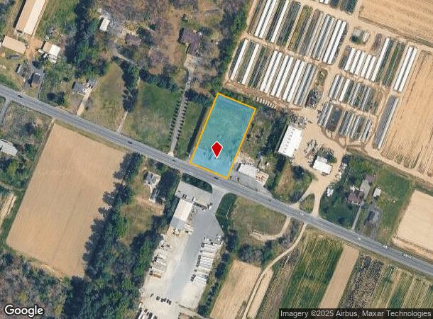
1008 Harding Hwy
05-07101-0000-00037
ADDITIONAL LOTS: PURPLE PENGUIN
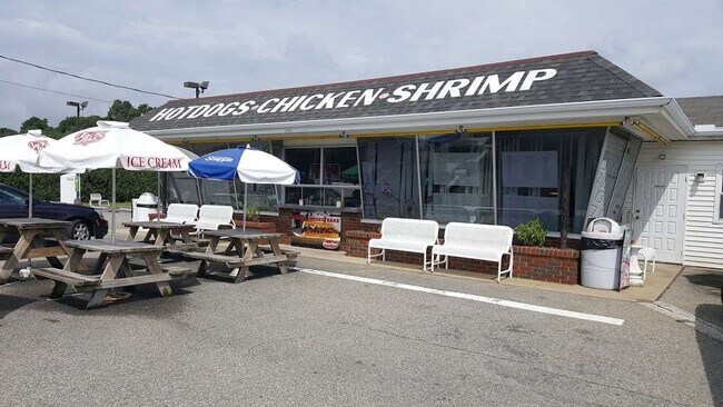
Restaurantbuilding
Gloucester
X
New Jersey
34001C0090F
37
2024
1.24 AC
2025
Gloucester County
501702
Philadelphia
1,176 SF
Philadelphia-Camden-Wilmington, PA-NJ-DE-MD
DEMOGRAPHICS near 1008 Harding Hwy
1 Mile
3 Mile
5 Mile
2024 Total Population
429
9,517
38,801
2029 Population
435
9,578
38,564
Pop Growth 2024-2029
+ 1.40%
+ 0.64%
(0.61%)
Average Age
44
42
41
2024 Total Households
161
3,632
14,386
HH Growth 2024-2029
+ 1.24%
+ 0.39%
(0.75%)
Median Household Inc
$94,999
$83,519
$67,403
Avg Household Size
2.60
2.60
2.60
2024 Avg HH Vehicles
2.00
2.00
2.00
Median Home Value
$238,043
$230,987
$199,948
Median Year Built
1978
1974
1969
Nearby Places
Map Layers
Map Styles
 Street
 Aerial
- Restaurants
- Banks
- Shops
- Fitness
- Groceries
PUBLIC TRANSPORTATION
AIRPORT
Atlantic City International
DRIVE
WALK
Distance
Atlantic City International
61 min
28.0 mi
Philadelphia International
DRIVE
WALK
Distance
Philadelphia International
58 min
36.5 mi
Freight Ports
Broadway Terminal - Pier 5
DRIVE
WALK
Distance
Broadway Terminal - Pier 5
42 min
27.9 mi
SALE & LEASE HISTORY
LISTING DATE
SALE/LEASE

Mar 12, 2020
For Sale
Nearby Properties
Address
Land Use
TOTAL SIZE
Lot Size
Zoning
Address
Land Use
TOTAL SIZE
Lot Size
Zoning
8.53 AC
R-3
Address
Land Use
TOTAL SIZE
Lot Size
Zoning
44.19 AC
PIRA
Address
Land Use
TOTAL SIZE
Lot Size
Zoning
4,936 SF
35.45 AC
RA
Address
Land Use
TOTAL SIZE
Lot Size
Zoning
22.29 AC
A
Address
Land Use
TOTAL SIZE
Lot Size
Zoning
10.33 AC
RA
Address
Land Use
TOTAL SIZE
Lot Size
Zoning
1,358 SF
9.10 AC
RA
Address
Land Use
TOTAL SIZE
Lot Size
Zoning
2.44 AC
I2
Address
Land Use
TOTAL SIZE
Lot Size
Zoning
6.37 AC
RA
Address
Land Use
TOTAL SIZE
Lot Size
Zoning
Address
Land Use
TOTAL SIZE
Lot Size
Zoning
3.07 AC
R-2
Address
Land Use
TOTAL SIZE
Lot Size
Zoning
13.12 AC
I
Address
Land Use
TOTAL SIZE
Lot Size
Zoning
7.94 AC
R2
Address
Land Use
TOTAL SIZE
Lot Size
Zoning
4.28 AC
R-3
Address
Land Use
TOTAL SIZE
Lot Size
Zoning
12 AC
PAP
Address
Land Use
TOTAL SIZE
Lot Size
Zoning
1,344 SF
49.22 AC
LM
Address
Land Use
TOTAL SIZE
Lot Size
Zoning
4 AC
C
Address
Land Use
TOTAL SIZE
Lot Size
Zoning
3,060 SF
6 AC
PAP
Address
Land Use
TOTAL SIZE
Lot Size
Zoning
1.95 AC
Address
Land Use
TOTAL SIZE
Lot Size
Zoning
7.36 AC
RA
Address
Land Use
TOTAL SIZE
Lot Size
Zoning
1.88 AC
I2
Address
Land Use
TOTAL SIZE
Lot Size
Zoning
15.63 AC
A
Address
Land Use
TOTAL SIZE
Lot Size
Zoning
11.59 AC
R-4
Address
Land Use
TOTAL SIZE
Lot Size
Zoning
54.66 AC
MH
Address
Land Use
TOTAL SIZE
Lot Size
Zoning
2,496 SF
2.56 AC
01
Address
Land Use
TOTAL SIZE
Lot Size
Zoning
18.80 AC
R-3
Address
Land Use
TOTAL SIZE
Lot Size
Zoning
Address
Land Use
TOTAL SIZE
Lot Size
Zoning
3.80 AC
R4
Address
Land Use
TOTAL SIZE
Lot Size
Zoning
6.21 AC
Address
Land Use
TOTAL SIZE
Lot Size
Zoning
1.92 AC
C
Address
Land Use
TOTAL SIZE
Lot Size
Zoning
7.33 AC
R3
The World's #1 Commercial Real Estate Marketplace
Connect with us
© 2025 CoStar Group
The information above has been obtained from sources believed reliable. While we do not doubt its accuracy we have not verified it and make no guarantee, warranty or representation about it. It is your responsibility to independently confirm its accuracy and completeness. Any projections, opinions, assumptions, or estimates used are for example only and do not represent the current or future performance of the property. The value of this transaction to you depends on tax and other factors which should be evaluated by your tax, financial, and legal advisors. You and your advisors should conduct a careful, independent investigation of the property to determine to your satisfaction the suitability of the property for your needs.