Property Record
1008 Henderson Levee Rd, Breaux Bridge, LA 70517

Save to a Folder
{{folder.Name}}
{{folder.ListingIds.length}} Properties
{{folder.ListingIds.length}} Property
Create a New Folder
This Property Is For Sale
Property Detail
1008 Henderson Levee Rd
Lafayette, LA
LOT 220 X 125.75 X 71 X 125.97 X 121.30 X 263.47 LOT 21, STREET & LOT 2, LOT 2 & 3, CANAL (BEING LOT 1 ON PLAT #240966) COB.
06201B4356
ST MARTIN
Commercialnec
Louisiana
AE The base floodplain where base flood elevations are provided. AE Zones are now used on new format FIRMs instead of A1-A30 Zones.
1
2025
1.73 AC
2025
St Martin Parish
020502
Lafayette
6,322 SF
NEARBY LISTINGS FOR SALE OR LEASE
-
-
View all Breaux Bridge listings for sale on LoopNet.com
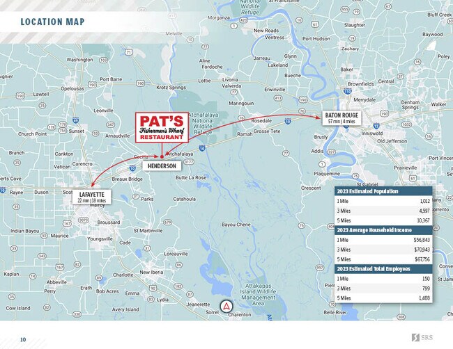
DEMOGRAPHICS near 1008 Henderson Levee Rd
1 mile
3 mile
5 mile
2025 Total Population
1,069
4,741
9,723
2030 Population
1,061
4,649
9,575
Pop Growth 2025-2030
(0.75%)
(1.94%)
(1.52%)
Average Age
38
40
40
2025 Total Households
374
1,796
3,725
HH Growth 2025-2030
(0.80%)
(2.12%)
(1.64%)
Median Household Inc
$38,937
$66,683
$64,571
Avg Household Size
2.70
2.60
2.50
2025 Avg HH Vehicles
2.00
2.00
2.00
Median Home Value
$94,594
$152,157
$160,315
Median Year Built
1978
1983
1987
Nearby Places
Map Layers
Map Styles
 Street
 Aerial
Layers
 Traffic
 Biking
Places
Listings with unknown addresses are not visible on the map
- Restaurants
- Banks
- Shops
- Fitness
- Groceries
PUBLIC TRANSPORTATION
AIRPORT
Lafayette Regional/Paul Fournet Field
Drive
Walk
Distance
Lafayette Regional/Paul Fournet Field
26 min
18.0 mi
Freight Ports
Port of Iberia
Drive
Walk
Distance
Port of Iberia
53 min
40.1 mi
Nearby Properties
Address
Land Use
TOTAL SIZE
Lot Size
Zoning
Address
Land Use
TOTAL SIZE
Lot Size
Zoning
4,800 SF
84.43 AC
Address
Land Use
TOTAL SIZE
Lot Size
Zoning
Address
Land Use
TOTAL SIZE
Lot Size
Zoning
26,950 SF
4.86 AC
Address
Land Use
TOTAL SIZE
Lot Size
Zoning
Address
Land Use
TOTAL SIZE
Lot Size
Zoning
8,700 SF
5.60 AC
Address
Land Use
TOTAL SIZE
Lot Size
Zoning
37,728 SF
14.63 AC
Address
Land Use
TOTAL SIZE
Lot Size
Zoning
14,560 SF
2.14 AC
Address
Land Use
TOTAL SIZE
Lot Size
Zoning
1,512 SF
787.36 AC
Address
Land Use
TOTAL SIZE
Lot Size
Zoning
1,801 SF
0.34 AC
Address
Land Use
TOTAL SIZE
Lot Size
Zoning
3,050 SF
6 AC
Address
Land Use
TOTAL SIZE
Lot Size
Zoning
8,990 SF
7.28 AC
Address
Land Use
TOTAL SIZE
Lot Size
Zoning
3,390 SF
1.92 AC
Address
Land Use
TOTAL SIZE
Lot Size
Zoning
1,904 SF
2.58 AC
Address
Land Use
TOTAL SIZE
Lot Size
Zoning
1,680 SF
1.16 AC
Address
Land Use
TOTAL SIZE
Lot Size
Zoning
12,624 SF
1.50 AC
Address
Land Use
TOTAL SIZE
Lot Size
Zoning
3,750 SF
2.19 AC
Address
Land Use
TOTAL SIZE
Lot Size
Zoning
2,400 SF
0.79 AC
Address
Land Use
TOTAL SIZE
Lot Size
Zoning
1,280 SF
2.32 AC
Address
Land Use
TOTAL SIZE
Lot Size
Zoning
1,820 SF
2.02 AC
Address
Land Use
TOTAL SIZE
Lot Size
Zoning
2,864 SF
0.57 AC
Address
Land Use
TOTAL SIZE
Lot Size
Zoning
8,400 SF
0.97 AC
Address
Land Use
TOTAL SIZE
Lot Size
Zoning
7,033 SF
2.31 AC
Address
Land Use
TOTAL SIZE
Lot Size
Zoning
2,326 SF
0.58 AC
Address
Land Use
TOTAL SIZE
Lot Size
Zoning
2,536 SF
0.52 AC
Address
Land Use
TOTAL SIZE
Lot Size
Zoning
Address
Land Use
TOTAL SIZE
Lot Size
Zoning
13,871 SF
2.95 AC
Address
Land Use
TOTAL SIZE
Lot Size
Zoning
12,000 SF
11.04 AC
Address
Land Use
TOTAL SIZE
Lot Size
Zoning
1,433 SF
2.48 AC
Address
Land Use
TOTAL SIZE
Lot Size
Zoning
2,000 SF
0.97 AC
Address
Land Use
TOTAL SIZE
Lot Size
Zoning
4,340 SF
0.59 AC
The World's #1 Commercial Real Estate Marketplace
Connect with us
© 2026 CoStar Group
The information above has been obtained from sources believed reliable. While we do not doubt its accuracy we have not verified it and make no guarantee, warranty or representation about it. It is your responsibility to independently confirm its accuracy and completeness. Any projections, opinions, assumptions, or estimates used are for example only and do not represent the current or future performance of the property. The value of this transaction to you depends on tax and other factors which should be evaluated by your tax, financial, and legal advisors. You and your advisors should conduct a careful, independent investigation of the property to determine to your satisfaction the suitability of the property for your needs.