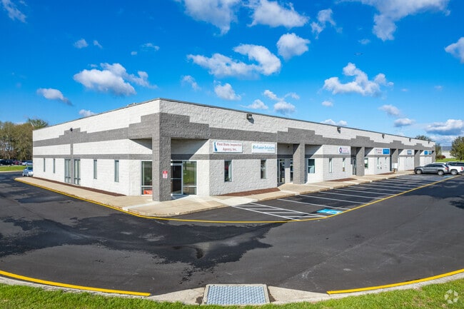
Property Record
1002 Mattlind Way, Milford, DE 19963
NEARBY LISTINGS FOR SALE OR LEASE
Property Detail
1002 Mattlind Way
5-16-17300-01-0303-000
Lands Timothy S Johnson&Jeanni
Commercialnec
S. SIDE CO. RD. #407, AIRPORT ROAD,BUT NOT ADJ., 2.80 A.
X
Kent
10001C0362J
Delaware
2024
2.80 AC
2025
Kent County
043400
Philadelphia
24,990 SF
Dover, DE
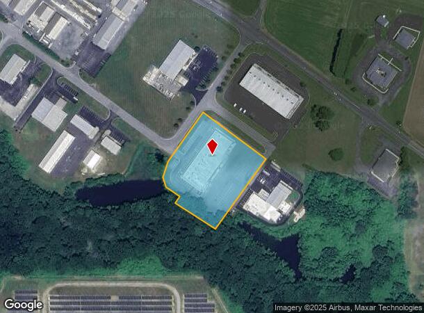
DEMOGRAPHICS near 1002 Mattlind Way
1 Mile
3 Mile
5 Mile
2024 Total Population
1,753
14,528
25,645
2029 Population
1,882
16,210
28,611
Pop Growth 2024-2029
+ 7.36%
+ 11.58%
+ 11.57%
Average Age
40
40
42
2024 Total Households
698
5,548
9,828
HH Growth 2024-2029
+ 7.59%
+ 11.23%
+ 11.24%
Median Household Inc
$49,743
$55,173
$59,681
Avg Household Size
2.50
2.50
2.50
2024 Avg HH Vehicles
2.00
2.00
2.00
Median Home Value
$304,701
$265,908
$272,540
Median Year Built
1986
1984
1991
Nearby Places
Map Layers
Map Styles
 Street
 Aerial
- Restaurants
- Banks
- Shops
- Fitness
- Groceries
SALE & LEASE HISTORY
LISTING DATE
SALE/LEASE

Sep 03, 2025
For Lease
Nov 18, 2020
For Lease
Nearby Properties
Address
Land Use
TOTAL SIZE
Lot Size
Zoning
Address
Land Use
TOTAL SIZE
Lot Size
Zoning
170,788 SF
69.90 AC
R2
Address
Land Use
TOTAL SIZE
Lot Size
Zoning
180,878 SF
21.43 AC
C3
Address
Land Use
TOTAL SIZE
Lot Size
Zoning
111,133 SF
22.99 AC
OC1
Address
Land Use
TOTAL SIZE
Lot Size
Zoning
68,127 SF
14.97 AC
H1
Address
Land Use
TOTAL SIZE
Lot Size
Zoning
130,101 SF
13.80 AC
C3
Address
Land Use
TOTAL SIZE
Lot Size
Zoning
204,457 SF
18.50 AC
C3
Address
Land Use
TOTAL SIZE
Lot Size
Zoning
185,027 SF
24.54 AC
I2
Address
Land Use
TOTAL SIZE
Lot Size
Zoning
44,037 SF
23.20 AC
BG
Address
Land Use
TOTAL SIZE
Lot Size
Zoning
99,488 SF
18.20 AC
R3
Address
Land Use
TOTAL SIZE
Lot Size
Zoning
61,585 SF
10.55 AC
R2
Address
Land Use
TOTAL SIZE
Lot Size
Zoning
72,706 SF
10.60 AC
C3
Address
Land Use
TOTAL SIZE
Lot Size
Zoning
88,015 SF
8 AC
C3
Address
Land Use
TOTAL SIZE
Lot Size
Zoning
191,470 SF
49.58 AC
IL
Address
Land Use
TOTAL SIZE
Lot Size
Zoning
72,084 SF
4.90 AC
R3
Address
Land Use
TOTAL SIZE
Lot Size
Zoning
23,312 SF
27.90 AC
C3
Address
Land Use
TOTAL SIZE
Lot Size
Zoning
180,174 SF
17.51 AC
I1
Address
Land Use
TOTAL SIZE
Lot Size
Zoning
46,784 SF
2.30 AC
C3
Address
Land Use
TOTAL SIZE
Lot Size
Zoning
49,500 SF
7.40 AC
R3
Address
Land Use
TOTAL SIZE
Lot Size
Zoning
47,754 SF
25.50 AC
I1
Address
Land Use
TOTAL SIZE
Lot Size
Zoning
37,022 SF
11.80 AC
OC1
Address
Land Use
TOTAL SIZE
Lot Size
Zoning
42,400 SF
9 AC
R3
Address
Land Use
TOTAL SIZE
Lot Size
Zoning
72,084 SF
5.60 AC
R3
Address
Land Use
TOTAL SIZE
Lot Size
Zoning
50,304 SF
8.90 AC
R3
Address
Land Use
TOTAL SIZE
Lot Size
Zoning
Address
Land Use
TOTAL SIZE
Lot Size
Zoning
68,299 SF
11.50 AC
OC1
Address
Land Use
TOTAL SIZE
Lot Size
Zoning
19,200 SF
34.40 AC
PUD
Address
Land Use
TOTAL SIZE
Lot Size
Zoning
23,400 SF
6.90 AC
I1
Address
Land Use
TOTAL SIZE
Lot Size
Zoning
44,886 SF
2.73 AC
C2
Address
Land Use
TOTAL SIZE
Lot Size
Zoning
30,628 SF
15.90 AC
I1
Address
Land Use
TOTAL SIZE
Lot Size
Zoning
26,472 SF
8.20 AC
R3
The World's #1 Commercial Real Estate Marketplace
Connect with us
© 2025 CoStar Group
The information above has been obtained from sources believed reliable. While we do not doubt its accuracy we have not verified it and make no guarantee, warranty or representation about it. It is your responsibility to independently confirm its accuracy and completeness. Any projections, opinions, assumptions, or estimates used are for example only and do not represent the current or future performance of the property. The value of this transaction to you depends on tax and other factors which should be evaluated by your tax, financial, and legal advisors. You and your advisors should conduct a careful, independent investigation of the property to determine to your satisfaction the suitability of the property for your needs.