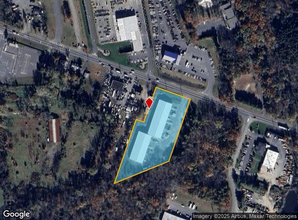
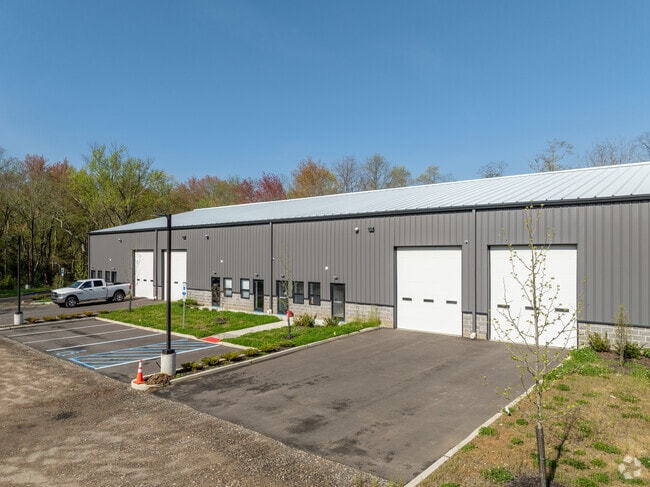
Property Record
1008 Route 33, Freehold, NJ 07728

NEARBY LISTINGS FOR SALE OR LEASE
Property Detail
1008 Route 33
21-00177-0000-00028-01
Monmouth
Industrialgeneral
New Jersey
X
28.1
34025C0302F
2.99 AC
2024
Western Monmouth
2025
Northern New Jersey
811402
Lakewood-New Brunswick, NJ
DEMOGRAPHICS near 1008 Route 33
1 Mile
3 Mile
5 Mile
2024 Total Population
707
16,452
66,710
2029 Population
698
16,320
65,976
Pop Growth 2024-2029
(1.27%)
(0.80%)
(1.10%)
Average Age
41
45
41
2024 Total Households
231
6,336
23,608
HH Growth 2024-2029
(1.30%)
(0.87%)
(1.28%)
Median Household Inc
$149,999
$106,565
$109,313
Avg Household Size
3.00
2.50
2.70
2024 Avg HH Vehicles
3.00
2.00
2.00
Median Home Value
$686,708
$544,296
$485,190
Median Year Built
1994
1987
1982
Nearby Places
Map Layers
Map Styles
 Street
 Aerial
- Restaurants
- Banks
- Shops
- Fitness
- Groceries
SALE & LEASE HISTORY
LISTING DATE
SALE/LEASE

Oct 03, 2025
For Lease
Oct 01, 2024
For Lease
Jun 15, 2020
For Lease
Apr 30, 2021
For Lease
Nearby Properties
Address
Land Use
TOTAL SIZE
Lot Size
Zoning
Address
Land Use
TOTAL SIZE
Lot Size
Zoning
3,255.78 AC
ARE6
Address
Land Use
TOTAL SIZE
Lot Size
Zoning
904,310 SF
85.13 AC
M2M1
Address
Land Use
TOTAL SIZE
Lot Size
Zoning
36.48 AC
HD-2
Address
Land Use
TOTAL SIZE
Lot Size
Zoning
267,666 SF
29.06 AC
M-1
Address
Land Use
TOTAL SIZE
Lot Size
Zoning
114,738 SF
19.02 AC
M-1
Address
Land Use
TOTAL SIZE
Lot Size
Zoning
13 AC
R-40
Address
Land Use
TOTAL SIZE
Lot Size
Zoning
1.06 AC
AG
Address
Land Use
TOTAL SIZE
Lot Size
Zoning
92,832 SF
29.69 AC
M-1
Address
Land Use
TOTAL SIZE
Lot Size
Zoning
126,300 SF
10.12 AC
M-1
Address
Land Use
TOTAL SIZE
Lot Size
Zoning
120,000 SF
77 AC
ARE2
Address
Land Use
TOTAL SIZE
Lot Size
Zoning
8,694 SF
73.93 AC
R-40
Address
Land Use
TOTAL SIZE
Lot Size
Zoning
56,000 SF
21.53 AC
M-1
Address
Land Use
TOTAL SIZE
Lot Size
Zoning
106,345 SF
10.53 AC
LI-3
Address
Land Use
TOTAL SIZE
Lot Size
Zoning
155,980 SF
23.83 AC
M-1
Address
Land Use
TOTAL SIZE
Lot Size
Zoning
119,817 SF
23 AC
R-60
Address
Land Use
TOTAL SIZE
Lot Size
Zoning
4,812 SF
179.80 AC
A-1
Address
Land Use
TOTAL SIZE
Lot Size
Zoning
49.95 AC
M-2
Address
Land Use
TOTAL SIZE
Lot Size
Zoning
61,840 SF
12.32 AC
LI-3
Address
Land Use
TOTAL SIZE
Lot Size
Zoning
42,354 SF
0.92 AC
LI-3
Address
Land Use
TOTAL SIZE
Lot Size
Zoning
36 AC
R-60
Address
Land Use
TOTAL SIZE
Lot Size
Zoning
35.45 AC
R-60
Address
Land Use
TOTAL SIZE
Lot Size
Zoning
64,871 SF
15 AC
R-60
Address
Land Use
TOTAL SIZE
Lot Size
Zoning
32,800 SF
6.32 AC
LI-3
Address
Land Use
TOTAL SIZE
Lot Size
Zoning
33.17 AC
LI-3
Address
Land Use
TOTAL SIZE
Lot Size
Zoning
42.76 AC
SED
Address
Land Use
TOTAL SIZE
Lot Size
Zoning
3,358 SF
16.33 AC
M-1
Address
Land Use
TOTAL SIZE
Lot Size
Zoning
33,128 SF
12.68 AC
ARE6
Address
Land Use
TOTAL SIZE
Lot Size
Zoning
113,086 SF
9.35 AC
M-1
Address
Land Use
TOTAL SIZE
Lot Size
Zoning
69,520 SF
11.02 AC
M-1
Address
Land Use
TOTAL SIZE
Lot Size
Zoning
14.69 AC
LI-3
The World's #1 Commercial Real Estate Marketplace
Connect with us
© 2026 CoStar Group
The information above has been obtained from sources believed reliable. While we do not doubt its accuracy we have not verified it and make no guarantee, warranty or representation about it. It is your responsibility to independently confirm its accuracy and completeness. Any projections, opinions, assumptions, or estimates used are for example only and do not represent the current or future performance of the property. The value of this transaction to you depends on tax and other factors which should be evaluated by your tax, financial, and legal advisors. You and your advisors should conduct a careful, independent investigation of the property to determine to your satisfaction the suitability of the property for your needs.