Property Record
10081 County Road 138, Saint Cloud, MN 56301


Property Detail
10081 County Road 138
31.21120.0025
3.63A PT OF SE4SW4&SW4SE4DAF BEG 621.49'W OF SE COROFSE4SW4-E61D 57'N1500.38'TONL OF SW4SE4-E453.58'TO RR-SW'LY 1501.12'TO
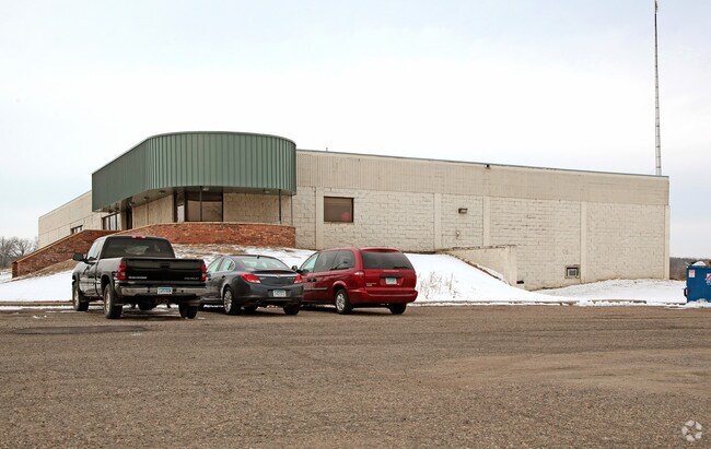
Gymhealthspa
Stearns
B and X Area of moderate flood hazard, usually the area between the limits of the 100-year and 500-year floods.
Minnesota
2026
3.63 AC
2025
Stearns County
011306
Minneapolis/St Paul
24,750 SF
St. Cloud, MN
NEARBY LISTINGS FOR SALE OR LEASE
-
-
View all Saint Cloud listings for sale on LoopNet.com
DEMOGRAPHICS near 10081 County Road 138
1 mile
3 mile
5 mile
2025 Total Population
285
2,568
14,936
2030 Population
282
2,638
15,693
Pop Growth 2025-2030
(1.05%)
+ 2.73%
+ 5.07%
Average Age
41
41
36
2025 Total Households
108
978
5,250
HH Growth 2025-2030
(0.93%)
+ 2.76%
+ 5.54%
Median Household Inc
$100,625
$81,402
$81,131
Avg Household Size
2.60
2.60
2.40
2025 Avg HH Vehicles
2.00
2.00
2.00
Median Home Value
$359,259
$337,790
$305,945
Median Year Built
1978
1981
1992
Nearby Places
Map Layers
Map Styles
 Street
 Aerial
Layers
 Traffic
 Biking
Places
Listings with unknown addresses are not visible on the map
- Restaurants
- Banks
- Shops
- Fitness
- Groceries
Nearby Properties
Address
Land Use
TOTAL SIZE
Lot Size
Zoning
Address
Land Use
TOTAL SIZE
Lot Size
Zoning
148,150 SF
71.46 AC
Address
Land Use
TOTAL SIZE
Lot Size
Zoning
Address
Land Use
TOTAL SIZE
Lot Size
Zoning
3,088 SF
67.89 AC
PL20B1
Address
Land Use
TOTAL SIZE
Lot Size
Zoning
138,365 SF
20.30 AC
Address
Land Use
TOTAL SIZE
Lot Size
Zoning
13,526 SF
18.60 AC
Address
Land Use
TOTAL SIZE
Lot Size
Zoning
31,272 SF
37.32 AC
Address
Land Use
TOTAL SIZE
Lot Size
Zoning
1,422 SF
144.14 AC
RPMKT
Address
Land Use
TOTAL SIZE
Lot Size
Zoning
269.90 AC
Address
Land Use
TOTAL SIZE
Lot Size
Zoning
10,491 SF
4 AC
Address
Land Use
TOTAL SIZE
Lot Size
Zoning
13,894 SF
2.58 AC
Address
Land Use
TOTAL SIZE
Lot Size
Zoning
168.63 AC
Address
Land Use
TOTAL SIZE
Lot Size
Zoning
2,244 SF
116.95 AC
2AIMP
Address
Land Use
TOTAL SIZE
Lot Size
Zoning
137.40 AC
PL20B1
Address
Land Use
TOTAL SIZE
Lot Size
Zoning
6,569 SF
0.35 AC
Address
Land Use
TOTAL SIZE
Lot Size
Zoning
6,174 SF
1.30 AC
Address
Land Use
TOTAL SIZE
Lot Size
Zoning
21,302 SF
9.37 AC
PL20B1
Address
Land Use
TOTAL SIZE
Lot Size
Zoning
13,948 SF
1.19 AC
Address
Land Use
TOTAL SIZE
Lot Size
Zoning
119 AC
PL20B2
Address
Land Use
TOTAL SIZE
Lot Size
Zoning
3,011 SF
50 AC
2AIMP
Address
Land Use
TOTAL SIZE
Lot Size
Zoning
238 SF
97.55 AC
Address
Land Use
TOTAL SIZE
Lot Size
Zoning
1,568 SF
20.39 AC
Address
Land Use
TOTAL SIZE
Lot Size
Zoning
1,128 SF
112.57 AC
PL20B2
Address
Land Use
TOTAL SIZE
Lot Size
Zoning
572 SF
9 AC
Address
Land Use
TOTAL SIZE
Lot Size
Zoning
16,420 SF
5.25 AC
Address
Land Use
TOTAL SIZE
Lot Size
Zoning
8,330 SF
70.97 AC
2B
Address
Land Use
TOTAL SIZE
Lot Size
Zoning
112.33 AC
2B
Address
Land Use
TOTAL SIZE
Lot Size
Zoning
120 AC
PL20B3
Address
Land Use
TOTAL SIZE
Lot Size
Zoning
77.93 AC
2B
Address
Land Use
TOTAL SIZE
Lot Size
Zoning
1,500 SF
106.15 AC
RPMKT
Address
Land Use
TOTAL SIZE
Lot Size
Zoning
116.40 AC
PL20B3
The World's #1 Commercial Real Estate Marketplace
Connect with us
© 2026 CoStar Group
The information above has been obtained from sources believed reliable. While we do not doubt its accuracy we have not verified it and make no guarantee, warranty or representation about it. It is your responsibility to independently confirm its accuracy and completeness. Any projections, opinions, assumptions, or estimates used are for example only and do not represent the current or future performance of the property. The value of this transaction to you depends on tax and other factors which should be evaluated by your tax, financial, and legal advisors. You and your advisors should conduct a careful, independent investigation of the property to determine to your satisfaction the suitability of the property for your needs.