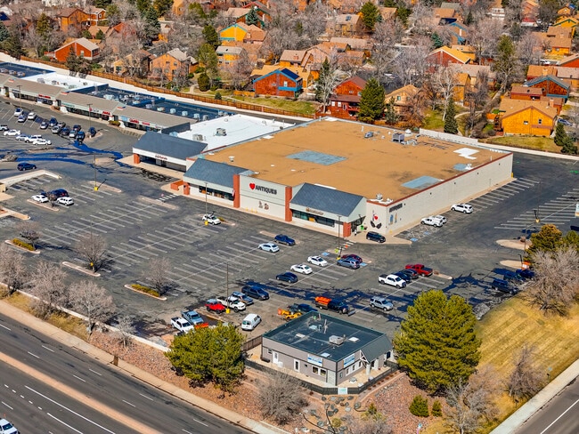
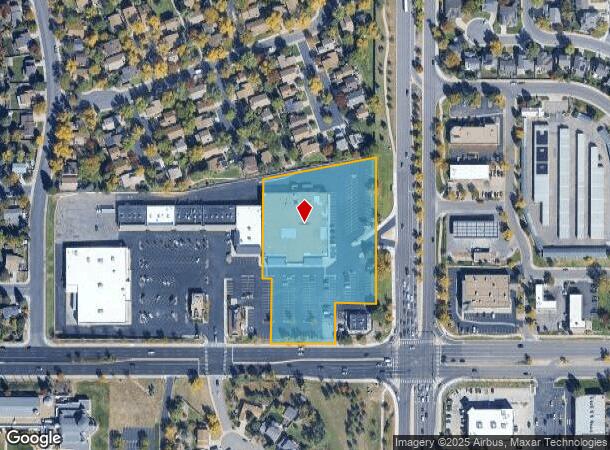
Property Record
10081 W Bowles Ave, Littleton, CO 80127


NEARBY LISTINGS FOR SALE OR LEASE
Property Detail
10081 W Bowles Ave
Denver-Aurora-Lakewood, CO
Westridge Square Ex Sur
59-164-12-066
SECTION 16 TOWNSHIP 05 RANGE 69 QTR SE SUBDIVISIONCD 828400 SUBDIVISIONNAME WESTRIDGE SQUARE EX SUR BLOCK LOT 0002 SIZE: 163194 TRACT VALUE: 3.746
Commercialnec
Jefferson
X
Colorado
0800460251H
2
2023
3.75 AC
2024
Southwest
012042
Denver
41,764 SF
DEMOGRAPHICS near 10081 W Bowles Ave
1 Mile
3 Mile
5 Mile
2024 Total Population
14,709
94,439
192,534
2029 Population
14,484
93,213
190,473
Pop Growth 2024-2029
(1.53%)
(1.30%)
(1.07%)
Average Age
42
42
42
2024 Total Households
5,504
36,814
76,913
HH Growth 2024-2029
(1.58%)
(1.30%)
(1.09%)
Median Household Inc
$116,823
$106,219
$101,901
Avg Household Size
2.60
2.50
2.40
2024 Avg HH Vehicles
2.00
2.00
2.00
Median Home Value
$519,336
$533,052
$557,687
Median Year Built
1986
1986
1984
Nearby Places
Map Layers
Map Styles
 Street
 Aerial
- Restaurants
- Banks
- Shops
- Fitness
- Groceries
PUBLIC TRANSPORTATION
AIRPORT
Denver International
DRIVE
WALK
Distance
Denver International
53 min
37.8 mi
SALE & LEASE HISTORY
LISTING DATE
SALE/LEASE

Apr 02, 2024
For Sale
Nearby Properties
Address
Land Use
TOTAL SIZE
Lot Size
Zoning
Address
Land Use
TOTAL SIZE
Lot Size
Zoning
272,246 SF
31.76 AC
PD
Address
Land Use
TOTAL SIZE
Lot Size
Zoning
381,135 SF
35.02 AC
Address
Land Use
TOTAL SIZE
Lot Size
Zoning
600,847 SF
32.41 AC
PD
Address
Land Use
TOTAL SIZE
Lot Size
Zoning
600,847 SF
35.87 AC
PD
Address
Land Use
TOTAL SIZE
Lot Size
Zoning
452,193 SF
12.56 AC
Address
Land Use
TOTAL SIZE
Lot Size
Zoning
391,595 SF
27.94 AC
Address
Land Use
TOTAL SIZE
Lot Size
Zoning
446,582 SF
19.24 AC
Address
Land Use
TOTAL SIZE
Lot Size
Zoning
178,421 SF
12.31 AC
PD
Address
Land Use
TOTAL SIZE
Lot Size
Zoning
293,292 SF
13.78 AC
S-CC
Address
Land Use
TOTAL SIZE
Lot Size
Zoning
304,475 SF
22.32 AC
Address
Land Use
TOTAL SIZE
Lot Size
Zoning
123,843 SF
6.03 AC
Address
Land Use
TOTAL SIZE
Lot Size
Zoning
329,538 SF
14.64 AC
B-4
Address
Land Use
TOTAL SIZE
Lot Size
Zoning
296,034 SF
14.26 AC
R-2-A
Address
Land Use
TOTAL SIZE
Lot Size
Zoning
189,672 SF
16.74 AC
PD
Address
Land Use
TOTAL SIZE
Lot Size
Zoning
94,367 SF
10.02 AC
R-2
Address
Land Use
TOTAL SIZE
Lot Size
Zoning
294,876 SF
12.25 AC
Address
Land Use
TOTAL SIZE
Lot Size
Zoning
85,580 SF
12.54 AC
Address
Land Use
TOTAL SIZE
Lot Size
Zoning
150,951 SF
17.90 AC
PD
Address
Land Use
TOTAL SIZE
Lot Size
Zoning
151,602 SF
38.93 AC
Address
Land Use
TOTAL SIZE
Lot Size
Zoning
101,699 SF
10.34 AC
Address
Land Use
TOTAL SIZE
Lot Size
Zoning
221,819 SF
33.64 AC
A1
Address
Land Use
TOTAL SIZE
Lot Size
Zoning
183,858 SF
9.30 AC
PUD
Address
Land Use
TOTAL SIZE
Lot Size
Zoning
101,795 SF
12.61 AC
PD
Address
Land Use
TOTAL SIZE
Lot Size
Zoning
105,093 SF
9.32 AC
B-2
Address
Land Use
TOTAL SIZE
Lot Size
Zoning
80,798 SF
12.27 AC
PD
Address
Land Use
TOTAL SIZE
Lot Size
Zoning
175,000 SF
36.25 AC
PD
Address
Land Use
TOTAL SIZE
Lot Size
Zoning
297,003 SF
26.77 AC
PD
Address
Land Use
TOTAL SIZE
Lot Size
Zoning
221,123 SF
14.82 AC
PD
Address
Land Use
TOTAL SIZE
Lot Size
Zoning
52,493 SF
12.69 AC
Address
Land Use
TOTAL SIZE
Lot Size
Zoning
97,000 SF
9.88 AC
PD
The World's #1 Commercial Real Estate Marketplace
Connect with us
© 2025 CoStar Group
The information above has been obtained from sources believed reliable. While we do not doubt its accuracy we have not verified it and make no guarantee, warranty or representation about it. It is your responsibility to independently confirm its accuracy and completeness. Any projections, opinions, assumptions, or estimates used are for example only and do not represent the current or future performance of the property. The value of this transaction to you depends on tax and other factors which should be evaluated by your tax, financial, and legal advisors. You and your advisors should conduct a careful, independent investigation of the property to determine to your satisfaction the suitability of the property for your needs.