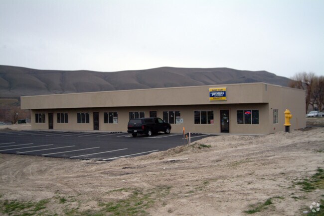
Property Record
1009 Dale Ave, Benton City, WA 99320

NEARBY LISTINGS FOR SALE OR LEASE
-
-
View all Benton City listings for sale on LoopNet.com
Property Detail
1009 Dale Ave
Kennewick-Richland, WA
Replat Of Assessors Plat #5
118973030011003
SECTION 18 TOWNSHIP 9 RANGE 27 REPLAT OF ASSESSORS PLAT #5 EAST 330 FEET TRACT 11A LYING SOUTH OF CENTER LINE OF COMMERICAL AVE SUBJECT TO EASEMENTS AND RESTRICTIONS OF RECORD (61652) DISSOLUTION OF DRAINAGE IMPROVEMENT DISTRICT 4 SUB A
Commercialnec
Benton
2024
Washington
2024
2.21 AC
011900
Yakima/Kennewick
11,350 SF
Other Market Areas
DEMOGRAPHICS near 1009 Dale Ave
1 Mile
3 Mile
5 Mile
2024 Total Population
2,921
6,903
9,209
2029 Population
3,092
7,322
9,795
Pop Growth 2024-2029
+ 5.85%
+ 6.07%
+ 6.36%
Average Age
38
39
40
2024 Total Households
1,099
2,506
3,355
HH Growth 2024-2029
+ 5.91%
+ 6.15%
+ 6.44%
Median Household Inc
$48,012
$61,901
$69,916
Avg Household Size
2.60
2.70
2.70
2024 Avg HH Vehicles
2.00
3.00
3.00
Median Home Value
$263,613
$303,964
$342,009
Median Year Built
1987
1987
1989
Nearby Places
Map Layers
Map Styles
 Street
 Aerial
- Restaurants
- Banks
- Shops
- Fitness
- Groceries
PUBLIC TRANSPORTATION
AIRPORT
Tri-Cities
DRIVE
WALK
Distance
Tri-Cities
29 min
21.2 mi
Nearby Properties
Address
Land Use
TOTAL SIZE
Lot Size
Zoning
Address
Land Use
TOTAL SIZE
Lot Size
Zoning
94,982 SF
26 AC
Address
Land Use
TOTAL SIZE
Lot Size
Zoning
101,649 SF
10.57 AC
Address
Land Use
TOTAL SIZE
Lot Size
Zoning
924 SF
Address
Land Use
TOTAL SIZE
Lot Size
Zoning
45,193 SF
6.38 AC
Address
Land Use
TOTAL SIZE
Lot Size
Zoning
110 AC
G.M.A. AGR
Address
Land Use
TOTAL SIZE
Lot Size
Zoning
9,376 SF
1.40 AC
Address
Land Use
TOTAL SIZE
Lot Size
Zoning
36,579 SF
74.77 AC
Address
Land Use
TOTAL SIZE
Lot Size
Zoning
29,161 SF
48.22 AC
G.M.A. AGR
Address
Land Use
TOTAL SIZE
Lot Size
Zoning
9,253 SF
493.10 AC
Address
Land Use
TOTAL SIZE
Lot Size
Zoning
24,392 SF
8.08 AC
Address
Land Use
TOTAL SIZE
Lot Size
Zoning
26,200 SF
4.93 AC
Address
Land Use
TOTAL SIZE
Lot Size
Zoning
5,883 SF
Address
Land Use
TOTAL SIZE
Lot Size
Zoning
18,180 SF
3.53 AC
Address
Land Use
TOTAL SIZE
Lot Size
Zoning
924 SF
256.76 AC
Address
Land Use
TOTAL SIZE
Lot Size
Zoning
Address
Land Use
TOTAL SIZE
Lot Size
Zoning
41.71 AC
Address
Land Use
TOTAL SIZE
Lot Size
Zoning
20,190 SF
2.60 AC
Address
Land Use
TOTAL SIZE
Lot Size
Zoning
14,240 SF
4.55 AC
Address
Land Use
TOTAL SIZE
Lot Size
Zoning
33,141 SF
3.81 AC
Address
Land Use
TOTAL SIZE
Lot Size
Zoning
31.80 AC
D2
Address
Land Use
TOTAL SIZE
Lot Size
Zoning
102.70 AC
G.M.A. AGR
Address
Land Use
TOTAL SIZE
Lot Size
Zoning
39.96 AC
G.M.A. AGR
Address
Land Use
TOTAL SIZE
Lot Size
Zoning
11,424 SF
2.88 AC
RURAL LAND
Address
Land Use
TOTAL SIZE
Lot Size
Zoning
10,718 SF
21.69 AC
Address
Land Use
TOTAL SIZE
Lot Size
Zoning
20,974 SF
2.08 AC
Address
Land Use
TOTAL SIZE
Lot Size
Zoning
25.07 AC
G.M.A. AGR
Address
Land Use
TOTAL SIZE
Lot Size
Zoning
4,704 SF
40 AC
G.M.A. AGR
Address
Land Use
TOTAL SIZE
Lot Size
Zoning
24.31 AC
G.M.A. AGR
Address
Land Use
TOTAL SIZE
Lot Size
Zoning
123.57 AC
G.M.A. AGR
Address
Land Use
TOTAL SIZE
Lot Size
Zoning
14,806 SF
2.30 AC
The World's #1 Commercial Real Estate Marketplace
Connect with us
© 2026 CoStar Group
The information above has been obtained from sources believed reliable. While we do not doubt its accuracy we have not verified it and make no guarantee, warranty or representation about it. It is your responsibility to independently confirm its accuracy and completeness. Any projections, opinions, assumptions, or estimates used are for example only and do not represent the current or future performance of the property. The value of this transaction to you depends on tax and other factors which should be evaluated by your tax, financial, and legal advisors. You and your advisors should conduct a careful, independent investigation of the property to determine to your satisfaction the suitability of the property for your needs.