Property Record
1009 E Amidon St, Sioux Falls, SD 57104
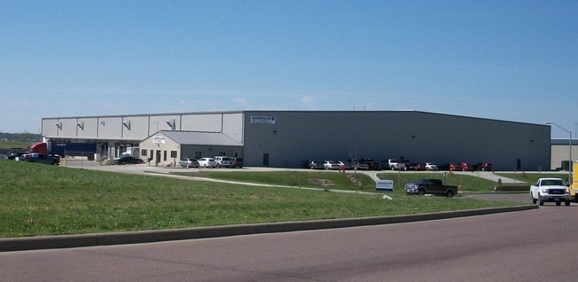


Property Detail
1009 E Amidon St
Sioux Falls, SD-MN
VAC E NORTH DR & SECTION LINE ROW LYING ADJ & 6 BLOCK 2 SIOUX EMPIRE DEVELOPME NT PARK 3 EAST ADDN TO CITY OF SIOUX F
77901
Minnehaha
Warehouse
South Dakota
B and X Area of moderate flood hazard, usually the area between the limits of the 100-year and 500-year floods.
6
2025
9.68 AC
2025
Sioux Falls
000100
Other Market Areas
93,290 SF
NEARBY LISTINGS FOR SALE OR LEASE
DEMOGRAPHICS near 1009 E Amidon St
1 mile
3 mile
5 mile
2025 Total Population
3,877
51,926
119,665
2030 Population
3,967
54,466
125,849
Pop Growth 2025-2030
+ 2.32%
+ 4.89%
+ 5.17%
Average Age
42
38
38
2025 Total Households
1,484
21,896
49,226
HH Growth 2025-2030
+ 2.36%
+ 5.40%
+ 5.61%
Median Household Inc
$54,014
$60,390
$65,963
Avg Household Size
2.40
2.20
2.30
2025 Avg HH Vehicles
2.00
2.00
2.00
Median Home Value
$151,686
$219,241
$269,383
Median Year Built
1977
1972
1982
Nearby Places
Map Layers
Map Styles
 Street
 Aerial
Layers
 Traffic
 Biking
Places
Listings with unknown addresses are not visible on the map
- Restaurants
- Banks
- Shops
- Fitness
- Groceries
PUBLIC TRANSPORTATION
AIRPORT
Joe Foss Field
Drive
Walk
Distance
Joe Foss Field
19 min
4.6 mi
Freight Ports
Port Milwaukee
Drive
Walk
Distance
Port Milwaukee
544 min
501.6 mi
Nearby Properties
Address
Land Use
TOTAL SIZE
Lot Size
Zoning
Address
Land Use
TOTAL SIZE
Lot Size
Zoning
3,217 SF
10.40 AC
NO;SPECIAL
Address
Land Use
TOTAL SIZE
Lot Size
Zoning
349,950 SF
32.99 AC
Address
Land Use
TOTAL SIZE
Lot Size
Zoning
179,266 SF
1.32 AC
FP;FP
Address
Land Use
TOTAL SIZE
Lot Size
Zoning
Address
Land Use
TOTAL SIZE
Lot Size
Zoning
184,821 SF
1.83 AC
NO;SPECIAL
Address
Land Use
TOTAL SIZE
Lot Size
Zoning
201,639 SF
2.30 AC
FP;FP
Address
Land Use
TOTAL SIZE
Lot Size
Zoning
14,820 SF
80.57 AC
FP;FP
Address
Land Use
TOTAL SIZE
Lot Size
Zoning
5,725 SF
77.41 AC
Address
Land Use
TOTAL SIZE
Lot Size
Zoning
15,704 SF
5.13 AC
Address
Land Use
TOTAL SIZE
Lot Size
Zoning
227,743 SF
90.58 AC
Address
Land Use
TOTAL SIZE
Lot Size
Zoning
3.07 AC
FP;FP
Address
Land Use
TOTAL SIZE
Lot Size
Zoning
1.20 AC
FP;FP
Address
Land Use
TOTAL SIZE
Lot Size
Zoning
212,076 SF
41.01 AC
FP;FP
Address
Land Use
TOTAL SIZE
Lot Size
Zoning
1.57 AC
C2;GENERAL
Address
Land Use
TOTAL SIZE
Lot Size
Zoning
50,160 SF
24.88 AC
Address
Land Use
TOTAL SIZE
Lot Size
Zoning
Address
Land Use
TOTAL SIZE
Lot Size
Zoning
123,441 SF
14.41 AC
Address
Land Use
TOTAL SIZE
Lot Size
Zoning
15,000 SF
29.88 AC
Address
Land Use
TOTAL SIZE
Lot Size
Zoning
3,254 SF
2.13 AC
Address
Land Use
TOTAL SIZE
Lot Size
Zoning
205,572 SF
22.50 AC
Address
Land Use
TOTAL SIZE
Lot Size
Zoning
35,688 SF
8.27 AC
FP;FP
Address
Land Use
TOTAL SIZE
Lot Size
Zoning
86,019 SF
3.60 AC
NO;SPECIAL
Address
Land Use
TOTAL SIZE
Lot Size
Zoning
33,416 SF
9.87 AC
Address
Land Use
TOTAL SIZE
Lot Size
Zoning
1.08 AC
Address
Land Use
TOTAL SIZE
Lot Size
Zoning
2.26 AC
FP;FP
Address
Land Use
TOTAL SIZE
Lot Size
Zoning
146,719 SF
1.65 AC
Address
Land Use
TOTAL SIZE
Lot Size
Zoning
171,429 SF
18.37 AC
Address
Land Use
TOTAL SIZE
Lot Size
Zoning
173,905 SF
10 AC
Address
Land Use
TOTAL SIZE
Lot Size
Zoning
89,935 SF
4.81 AC
Address
Land Use
TOTAL SIZE
Lot Size
Zoning
62,856 SF
11.26 AC
The World's #1 Commercial Real Estate Marketplace
Connect with us
© 2026 CoStar Group
The information above has been obtained from sources believed reliable. While we do not doubt its accuracy we have not verified it and make no guarantee, warranty or representation about it. It is your responsibility to independently confirm its accuracy and completeness. Any projections, opinions, assumptions, or estimates used are for example only and do not represent the current or future performance of the property. The value of this transaction to you depends on tax and other factors which should be evaluated by your tax, financial, and legal advisors. You and your advisors should conduct a careful, independent investigation of the property to determine to your satisfaction the suitability of the property for your needs.