Property Record
1009 Highway 2, Sandpoint, ID 83864
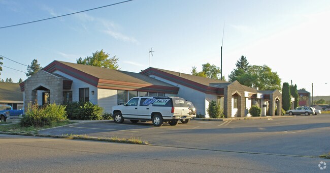

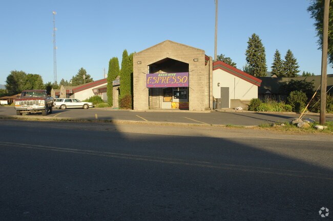
Property Detail
1009 Highway 2
Sandpoint, ID
22-57N-2W SOUTHMAYD,MCK,WILSON BLK 8 LOT 7 LESS N 35FT, ALL LOTS 8 & 9; LOTS 14,15 & 16 LESS HWY;PART OF VACATED ALLEY CRESCE
RPS04-350-08007CA
Bonner
Commercialnec
Idaho
B and X Area of moderate flood hazard, usually the area between the limits of the 100-year and 500-year floods.
7-16
2025
0.62 AC
2025
Bonner
950403
Coeur D'Alene
7,368 SF
NEARBY LISTINGS FOR SALE OR LEASE
DEMOGRAPHICS near 1009 Highway 2
1 mile
3 mile
5 mile
2024 Total Population
7,990
14,424
21,778
2029 Population
8,796
15,907
24,074
Pop Growth 2024-2029
+ 10.09%
+ 10.28%
+ 10.54%
Average Age
43
43
44
2024 Total Households
3,498
6,217
9,142
HH Growth 2024-2029
+ 9.75%
+ 9.94%
+ 10.17%
Median Household Inc
$71,510
$68,466
$70,537
Avg Household Size
2.20
2.20
2.30
2024 Avg HH Vehicles
2.00
2.00
2.00
Median Home Value
$511,390
$515,319
$511,923
Median Year Built
1981
1989
1991
Nearby Places
Map Layers
Map Styles
 Street
 Aerial
Transit
 Traffic
 Biking
Places
Listings with unknown addresses are not visible on the map
- Restaurants
- Banks
- Shops
- Fitness
- Groceries
SALE & LEASE HISTORY
LISTING DATE
SALE/LEASE

Sep 24, 2016
For Sale
Dec 14, 2017
For Sale
Nearby Properties
Address
Land Use
TOTAL SIZE
Lot Size
Zoning
Address
Land Use
TOTAL SIZE
Lot Size
Zoning
3.84 AC
Address
Land Use
TOTAL SIZE
Lot Size
Zoning
24,639 SF
3 AC
Address
Land Use
TOTAL SIZE
Lot Size
Zoning
86,100 SF
1.79 AC
Address
Land Use
TOTAL SIZE
Lot Size
Zoning
49,500 SF
16.53 AC
Address
Land Use
TOTAL SIZE
Lot Size
Zoning
Address
Land Use
TOTAL SIZE
Lot Size
Zoning
4,413 SF
4.79 AC
Address
Land Use
TOTAL SIZE
Lot Size
Zoning
4,512 SF
3.90 AC
Address
Land Use
TOTAL SIZE
Lot Size
Zoning
156,891 SF
14.84 AC
Address
Land Use
TOTAL SIZE
Lot Size
Zoning
29,154 SF
3.80 AC
Address
Land Use
TOTAL SIZE
Lot Size
Zoning
92,969 SF
15.72 AC
Address
Land Use
TOTAL SIZE
Lot Size
Zoning
82,053 SF
5.26 AC
Address
Land Use
TOTAL SIZE
Lot Size
Zoning
35,708 SF
2.47 AC
Address
Land Use
TOTAL SIZE
Lot Size
Zoning
12,024 SF
2.86 AC
Address
Land Use
TOTAL SIZE
Lot Size
Zoning
1,306 SF
3.05 AC
Rec
Address
Land Use
TOTAL SIZE
Lot Size
Zoning
53,580 SF
5.63 AC
Address
Land Use
TOTAL SIZE
Lot Size
Zoning
106,375 SF
11.87 AC
Address
Land Use
TOTAL SIZE
Lot Size
Zoning
5,148 SF
0.91 AC
Address
Land Use
TOTAL SIZE
Lot Size
Zoning
38,980 SF
2.71 AC
Address
Land Use
TOTAL SIZE
Lot Size
Zoning
432 SF
7.46 AC
R-5
Address
Land Use
TOTAL SIZE
Lot Size
Zoning
88,699 SF
6.93 AC
Address
Land Use
TOTAL SIZE
Lot Size
Zoning
16,462 SF
1.63 AC
Address
Land Use
TOTAL SIZE
Lot Size
Zoning
32,130 SF
4.33 AC
Address
Land Use
TOTAL SIZE
Lot Size
Zoning
17,828 SF
1.21 AC
Address
Land Use
TOTAL SIZE
Lot Size
Zoning
20,396 SF
1.40 AC
Address
Land Use
TOTAL SIZE
Lot Size
Zoning
29,910 SF
2.96 AC
Address
Land Use
TOTAL SIZE
Lot Size
Zoning
38,496 SF
6.63 AC
Address
Land Use
TOTAL SIZE
Lot Size
Zoning
3.30 AC
Address
Land Use
TOTAL SIZE
Lot Size
Zoning
0.83 AC
Address
Land Use
TOTAL SIZE
Lot Size
Zoning
26,966 SF
2.69 AC
Address
Land Use
TOTAL SIZE
Lot Size
Zoning
92,969 SF
6.74 AC
The World's #1 Commercial Real Estate Marketplace
Connect with us
© 2026 CoStar Group
The information above has been obtained from sources believed reliable. While we do not doubt its accuracy we have not verified it and make no guarantee, warranty or representation about it. It is your responsibility to independently confirm its accuracy and completeness. Any projections, opinions, assumptions, or estimates used are for example only and do not represent the current or future performance of the property. The value of this transaction to you depends on tax and other factors which should be evaluated by your tax, financial, and legal advisors. You and your advisors should conduct a careful, independent investigation of the property to determine to your satisfaction the suitability of the property for your needs.