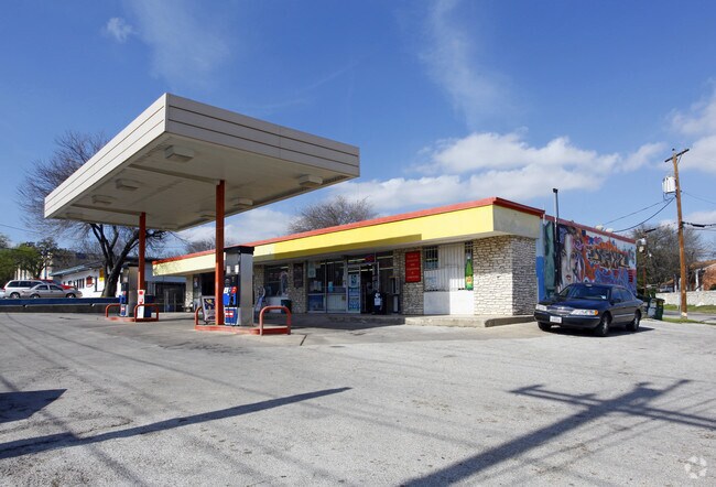
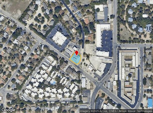
Property Record
1009 Jackson Keller Rd, San Antonio, TX 78213
NEARBY LISTINGS FOR SALE OR LEASE
Property Detail
1009 Jackson Keller Rd
San Antonio-New Braunfels, TX
Conv A/S Code
05008-017-0180
CB 5008G BLK LOT 18
Servicestation
Bexar
X
Texas
48029C0245G
18
2024
0.24 AC
2025
Northwest
191102
San Antonio
19,110 SF
DEMOGRAPHICS near 1009 Jackson Keller Rd
1 Mile
3 Mile
5 Mile
2024 Total Population
16,954
122,456
343,994
2029 Population
18,104
130,118
366,512
Pop Growth 2024-2029
+ 6.78%
+ 6.26%
+ 6.55%
Average Age
38
39
39
2024 Total Households
6,485
50,030
146,307
HH Growth 2024-2029
+ 7.12%
+ 6.58%
+ 6.86%
Median Household Inc
$42,464
$50,710
$51,843
Avg Household Size
2.50
2.40
2.20
2024 Avg HH Vehicles
2.00
2.00
2.00
Median Home Value
$214,184
$212,841
$247,611
Median Year Built
1965
1965
1973
Nearby Places
Map Layers
Map Styles
 Street
 Aerial
- Restaurants
- Banks
- Shops
- Fitness
- Groceries
PUBLIC TRANSPORTATION
COMMUTER RAIL
San Antonio Amtrak Station (Sunset Limited - Amtrak, Texas Eagle - Amtrak)
DRIVE
WALK
Distance
San Antonio Amtrak Station (Sunset Limited - Amtrak, Texas Eagle - Amtrak)
12 min
7.6 mi
AIRPORT
San Antonio International
DRIVE
WALK
Distance
San Antonio International
6 min
3.5 mi
Freight Ports
Calhoun Port
DRIVE
WALK
Distance
Calhoun Port
190 min
154.1 mi
SALE & LEASE HISTORY
LISTING DATE
SALE/LEASE

Sep 13, 2019
For Lease
Apr 26, 2019
For Lease
Nearby Properties
Address
Land Use
TOTAL SIZE
Lot Size
Zoning
Address
Land Use
TOTAL SIZE
Lot Size
Zoning
557,078 SF
10.73 AC
Address
Land Use
TOTAL SIZE
Lot Size
Zoning
632,091 SF
27.82 AC
Address
Land Use
TOTAL SIZE
Lot Size
Zoning
324,360 SF
15.05 AC
Address
Land Use
TOTAL SIZE
Lot Size
Zoning
246,000 SF
22.54 AC
Address
Land Use
TOTAL SIZE
Lot Size
Zoning
46,451 SF
7.03 AC
Address
Land Use
TOTAL SIZE
Lot Size
Zoning
317,537 SF
25.06 AC
Address
Land Use
TOTAL SIZE
Lot Size
Zoning
56,042 SF
14.60 AC
Address
Land Use
TOTAL SIZE
Lot Size
Zoning
262,515 SF
6.38 AC
Address
Land Use
TOTAL SIZE
Lot Size
Zoning
506,058 SF
25.23 AC
Address
Land Use
TOTAL SIZE
Lot Size
Zoning
250,990 SF
4.89 AC
Address
Land Use
TOTAL SIZE
Lot Size
Zoning
23,738 SF
4.84 AC
Address
Land Use
TOTAL SIZE
Lot Size
Zoning
152,676 SF
13.74 AC
Address
Land Use
TOTAL SIZE
Lot Size
Zoning
314,264 SF
4.27 AC
Address
Land Use
TOTAL SIZE
Lot Size
Zoning
219,400 SF
6.16 AC
Address
Land Use
TOTAL SIZE
Lot Size
Zoning
307,193 SF
7.18 AC
Address
Land Use
TOTAL SIZE
Lot Size
Zoning
245,160 SF
15.10 AC
Address
Land Use
TOTAL SIZE
Lot Size
Zoning
392,678 SF
21.04 AC
Address
Land Use
TOTAL SIZE
Lot Size
Zoning
248,547 SF
3.30 AC
Address
Land Use
TOTAL SIZE
Lot Size
Zoning
74,510 SF
6.58 AC
Address
Land Use
TOTAL SIZE
Lot Size
Zoning
272,273 SF
13.62 AC
Address
Land Use
TOTAL SIZE
Lot Size
Zoning
356,368 SF
18.58 AC
Address
Land Use
TOTAL SIZE
Lot Size
Zoning
Address
Land Use
TOTAL SIZE
Lot Size
Zoning
248,413 SF
3.23 AC
Address
Land Use
TOTAL SIZE
Lot Size
Zoning
122,292 SF
12.83 AC
Address
Land Use
TOTAL SIZE
Lot Size
Zoning
293,420 SF
9.24 AC
Address
Land Use
TOTAL SIZE
Lot Size
Zoning
256,678 SF
4.42 AC
Address
Land Use
TOTAL SIZE
Lot Size
Zoning
192,175 SF
5.08 AC
Address
Land Use
TOTAL SIZE
Lot Size
Zoning
308,299 SF
14.55 AC
Address
Land Use
TOTAL SIZE
Lot Size
Zoning
138,674 SF
11.14 AC
Address
Land Use
TOTAL SIZE
Lot Size
Zoning
58,461 SF
3.60 AC
The World's #1 Commercial Real Estate Marketplace
Connect with us
© 2025 CoStar Group
The information above has been obtained from sources believed reliable. While we do not doubt its accuracy we have not verified it and make no guarantee, warranty or representation about it. It is your responsibility to independently confirm its accuracy and completeness. Any projections, opinions, assumptions, or estimates used are for example only and do not represent the current or future performance of the property. The value of this transaction to you depends on tax and other factors which should be evaluated by your tax, financial, and legal advisors. You and your advisors should conduct a careful, independent investigation of the property to determine to your satisfaction the suitability of the property for your needs.