Property Record
1009 Lower Dallas Hwy, Dallas, NC 28034


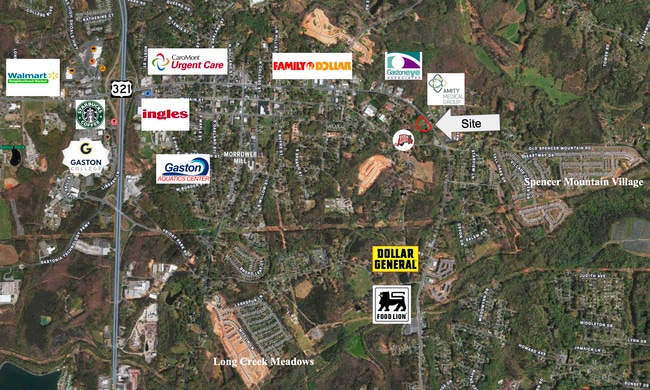
This Property Is For Sale
Current Lease Availabilities
NEARBY LISTINGS FOR SALE OR LEASE
Property Detail
1009 Lower Dallas Hwy
171424
13 091 069 03 000
Commercialofficeresidentialmixeduse
Gaston
X
North Carolina
3710355700J
2.17 AC
2025
Gaston County
2025
Charlotte
030902
Charlotte-Concord-Gastonia, NC-SC
1,260 SF
DEMOGRAPHICS near 1009 Lower Dallas Hwy
1 Mile
3 Mile
5 Mile
2024 Total Population
4,816
23,713
71,192
2029 Population
5,169
25,073
75,677
Pop Growth 2024-2029
+ 7.33%
+ 5.74%
+ 6.30%
Average Age
35
39
40
2024 Total Households
1,744
9,126
28,328
HH Growth 2024-2029
+ 7.34%
+ 5.86%
+ 6.45%
Median Household Inc
$51,431
$51,655
$47,438
Avg Household Size
2.70
2.50
2.40
2024 Avg HH Vehicles
2.00
2.00
2.00
Median Home Value
$174,197
$173,910
$179,285
Median Year Built
2000
1978
1972
Nearby Places
Map Layers
Map Styles
 Street
 Aerial
- Restaurants
- Banks
- Shops
- Fitness
- Groceries
PUBLIC TRANSPORTATION
COMMUTER RAIL
DRIVE
WALK
Distance
8 min
4.1 mi
AIRPORT
Charlotte/Douglas International
DRIVE
WALK
Distance
Charlotte/Douglas International
32 min
18.2 mi
Concord-Padgett Regional
DRIVE
WALK
Distance
Concord-Padgett Regional
46 min
34.5 mi
Nearby Properties
Address
Land Use
TOTAL SIZE
Lot Size
Zoning
Address
Land Use
TOTAL SIZE
Lot Size
Zoning
11,696 SF
159.68 AC
Address
Land Use
TOTAL SIZE
Lot Size
Zoning
192,315 SF
44.12 AC
INDS1
Address
Land Use
TOTAL SIZE
Lot Size
Zoning
103,890 SF
8.81 AC
OFF04
Address
Land Use
TOTAL SIZE
Lot Size
Zoning
2,688 SF
22.48 AC
OFF01
Address
Land Use
TOTAL SIZE
Lot Size
Zoning
176,657 SF
16.19 AC
Address
Land Use
TOTAL SIZE
Lot Size
Zoning
154,681 SF
63.07 AC
INDS1
Address
Land Use
TOTAL SIZE
Lot Size
Zoning
163,100 SF
41.60 AC
INDS1
Address
Land Use
TOTAL SIZE
Lot Size
Zoning
16,776 SF
49.87 AC
PUB01
Address
Land Use
TOTAL SIZE
Lot Size
Zoning
50,661 SF
2.32 AC
R1
Address
Land Use
TOTAL SIZE
Lot Size
Zoning
1,914 SF
15.78 AC
MRKT1
Address
Land Use
TOTAL SIZE
Lot Size
Zoning
13,017 SF
10.75 AC
REST1
Address
Land Use
TOTAL SIZE
Lot Size
Zoning
46,807 SF
4.36 AC
Address
Land Use
TOTAL SIZE
Lot Size
Zoning
3,328 SF
10.16 AC
APT02
Address
Land Use
TOTAL SIZE
Lot Size
Zoning
20,160 SF
18.47 AC
PUB01
Address
Land Use
TOTAL SIZE
Lot Size
Zoning
44,224 SF
3.32 AC
Address
Land Use
TOTAL SIZE
Lot Size
Zoning
19,609 SF
5.34 AC
OFF01
Address
Land Use
TOTAL SIZE
Lot Size
Zoning
4,228 SF
11.39 AC
APT02
Address
Land Use
TOTAL SIZE
Lot Size
Zoning
2,776 SF
57.41 AC
R1
Address
Land Use
TOTAL SIZE
Lot Size
Zoning
29,303 SF
5.38 AC
Address
Land Use
TOTAL SIZE
Lot Size
Zoning
3,832 SF
36.55 AC
Address
Land Use
TOTAL SIZE
Lot Size
Zoning
61,043 SF
30.34 AC
PUB01
Address
Land Use
TOTAL SIZE
Lot Size
Zoning
44,132 SF
1.90 AC
MOTL2
Address
Land Use
TOTAL SIZE
Lot Size
Zoning
2,053 SF
15.34 AC
OFF01
Address
Land Use
TOTAL SIZE
Lot Size
Zoning
115,534 SF
50.10 AC
PUB01
Address
Land Use
TOTAL SIZE
Lot Size
Zoning
70,288 SF
13.42 AC
INDS1
Address
Land Use
TOTAL SIZE
Lot Size
Zoning
36,300 SF
15.83 AC
Address
Land Use
TOTAL SIZE
Lot Size
Zoning
13,602 SF
8.74 AC
Address
Land Use
TOTAL SIZE
Lot Size
Zoning
2,145 SF
10.19 AC
Address
Land Use
TOTAL SIZE
Lot Size
Zoning
1,620 SF
6.73 AC
OFF01
Address
Land Use
TOTAL SIZE
Lot Size
Zoning
77,568 SF
1.65 AC
REST2
The World's #1 Commercial Real Estate Marketplace
Connect with us
© 2026 CoStar Group
The information above has been obtained from sources believed reliable. While we do not doubt its accuracy we have not verified it and make no guarantee, warranty or representation about it. It is your responsibility to independently confirm its accuracy and completeness. Any projections, opinions, assumptions, or estimates used are for example only and do not represent the current or future performance of the property. The value of this transaction to you depends on tax and other factors which should be evaluated by your tax, financial, and legal advisors. You and your advisors should conduct a careful, independent investigation of the property to determine to your satisfaction the suitability of the property for your needs.