Property Record
1009 Trident St, Hanahan, SC 29410
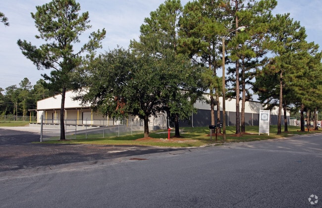

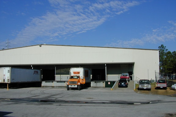
Property Detail
1009 Trident St
266-09-00-013
TRACT C COMM BONDED W HOUSE
Industrialgeneral
Berkeley
HANAHAN -
South Carolina
B and X Area of moderate flood hazard, usually the area between the limits of the 100-year and 500-year floods.
4.50 AC
2025
Outlying Berkeley County
2025
Charleston/N Charleston
021000
Charleston-North Charleston, SC
50,000 SF
NEARBY LISTINGS FOR SALE OR LEASE
DEMOGRAPHICS near 1009 Trident St
1 mile
3 mile
5 mile
2025 Total Population
8,674
40,508
111,219
2030 Population
9,500
43,824
120,065
Pop Growth 2025-2030
+ 9.52%
+ 8.19%
+ 7.95%
Average Age
37
38
37
2025 Total Households
3,528
16,623
43,147
HH Growth 2025-2030
+ 9.84%
+ 8.25%
+ 8.03%
Median Household Inc
$53,926
$65,949
$64,793
Avg Household Size
2.40
2.40
2.40
2025 Avg HH Vehicles
2.00
2.00
2.00
Median Home Value
$254,234
$330,628
$289,251
Median Year Built
1975
1982
1985
Nearby Places
Map Layers
Map Styles
 Street
 Aerial
Layers
 Traffic
 Biking
Places
Listings with unknown addresses are not visible on the map
- Restaurants
- Banks
- Shops
- Fitness
- Groceries
PUBLIC TRANSPORTATION
COMMUTER RAIL
Drive
Walk
Distance
7 min
3.2 mi
AIRPORT
Charleston AFB/International
Drive
Walk
Distance
Charleston AFB/International
16 min
9.2 mi
Freight Ports
North Charleston Terminal
Drive
Walk
Distance
North Charleston Terminal
2 min
0.5 mi
Nearby Properties
Address
Land Use
TOTAL SIZE
Lot Size
Zoning
Address
Land Use
TOTAL SIZE
Lot Size
Zoning
202,154 SF
16.34 AC
Address
Land Use
TOTAL SIZE
Lot Size
Zoning
7,200 SF
8.73 AC
Address
Land Use
TOTAL SIZE
Lot Size
Zoning
68,655 SF
9.48 AC
Address
Land Use
TOTAL SIZE
Lot Size
Zoning
105,666 SF
8.25 AC
Address
Land Use
TOTAL SIZE
Lot Size
Zoning
21,364 SF
7.71 AC
Address
Land Use
TOTAL SIZE
Lot Size
Zoning
10,560 SF
7.50 AC
Address
Land Use
TOTAL SIZE
Lot Size
Zoning
4,740 SF
12.17 AC
Address
Land Use
TOTAL SIZE
Lot Size
Zoning
48,885 SF
5.02 AC
Address
Land Use
TOTAL SIZE
Lot Size
Zoning
9,691 SF
10.34 AC
Address
Land Use
TOTAL SIZE
Lot Size
Zoning
133.75 AC
MUC_DC
Address
Land Use
TOTAL SIZE
Lot Size
Zoning
1,303 SF
4.77 AC
Address
Land Use
TOTAL SIZE
Lot Size
Zoning
30,064 SF
33.86 AC
Address
Land Use
TOTAL SIZE
Lot Size
Zoning
167,100 SF
8 AC
Address
Land Use
TOTAL SIZE
Lot Size
Zoning
25.97 AC
Address
Land Use
TOTAL SIZE
Lot Size
Zoning
86,024 SF
9.69 AC
Address
Land Use
TOTAL SIZE
Lot Size
Zoning
14,250 SF
2.08 AC
Address
Land Use
TOTAL SIZE
Lot Size
Zoning
1,236 SF
1.88 AC
Address
Land Use
TOTAL SIZE
Lot Size
Zoning
Address
Land Use
TOTAL SIZE
Lot Size
Zoning
40,050 SF
2.33 AC
Address
Land Use
TOTAL SIZE
Lot Size
Zoning
17,508 SF
8.79 AC
Address
Land Use
TOTAL SIZE
Lot Size
Zoning
Address
Land Use
TOTAL SIZE
Lot Size
Zoning
11.58 AC
Address
Land Use
TOTAL SIZE
Lot Size
Zoning
Address
Land Use
TOTAL SIZE
Lot Size
Zoning
Address
Land Use
TOTAL SIZE
Lot Size
Zoning
Address
Land Use
TOTAL SIZE
Lot Size
Zoning
Address
Land Use
TOTAL SIZE
Lot Size
Zoning
Address
Land Use
TOTAL SIZE
Lot Size
Zoning
28,580 SF
7.65 AC
Address
Land Use
TOTAL SIZE
Lot Size
Zoning
Address
Land Use
TOTAL SIZE
Lot Size
Zoning
5,550 SF
0.25 AC
The World's #1 Commercial Real Estate Marketplace
Connect with us
© 2026 CoStar Group
The information above has been obtained from sources believed reliable. While we do not doubt its accuracy we have not verified it and make no guarantee, warranty or representation about it. It is your responsibility to independently confirm its accuracy and completeness. Any projections, opinions, assumptions, or estimates used are for example only and do not represent the current or future performance of the property. The value of this transaction to you depends on tax and other factors which should be evaluated by your tax, financial, and legal advisors. You and your advisors should conduct a careful, independent investigation of the property to determine to your satisfaction the suitability of the property for your needs.