Property Record
1009 W Main St, Haw River, NC 27258

Save to a Folder
{{folder.Name}}
{{folder.ListingIds.length}} Properties
{{folder.ListingIds.length}} Property
Create a New Folder
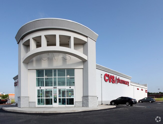
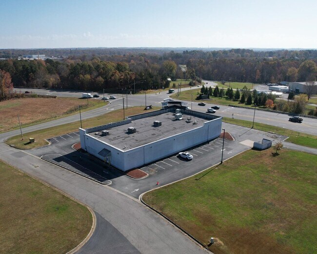
Property Detail
1009 W Main St
149554
VILLAGE MARKET PLACE PARCEL D 13-10-49
Storebuilding
ALAMANCE
B 2
North Carolina
B and X Area of moderate flood hazard, usually the area between the limits of the 100-year and 500-year floods.
1.24 AC
2025
N Central Alamance County
2025
Greensboro/Winston-Salem
020302
Burlington, NC
10,499 SF
NEARBY LISTINGS FOR SALE OR LEASE
DEMOGRAPHICS near 1009 W Main St
1 mile
3 mile
5 mile
2025 Total Population
3,895
38,155
80,859
2030 Population
4,083
40,343
85,468
Pop Growth 2025-2030
+ 4.83%
+ 5.73%
+ 5.70%
Average Age
38
39
40
2025 Total Households
1,412
15,199
32,642
HH Growth 2025-2030
+ 5.03%
+ 5.94%
+ 5.85%
Median Household Inc
$47,222
$49,386
$56,470
Avg Household Size
2.70
2.40
2.40
2025 Avg HH Vehicles
2.00
2.00
2.00
Median Home Value
$154,356
$161,278
$212,057
Median Year Built
1971
1972
1977
Nearby Places
Map Layers
Map Styles
 Street
 Aerial
Layers
 Traffic
 Biking
Places
Listings with unknown addresses are not visible on the map
- Restaurants
- Banks
- Shops
- Fitness
- Groceries
PUBLIC TRANSPORTATION
COMMUTER RAIL
Burlington Station (Piedmont - North Carolina by Train (NC Train))
Drive
Walk
Distance
Burlington Station (Piedmont - North Carolina by Train (NC Train))
7 min
4.1 mi
Freight Ports
Virginia Port Authority - Richmond
Drive
Walk
Distance
Virginia Port Authority - Richmond
203 min
174.9 mi
SALE & LEASE HISTORY
LISTING DATE
SALE/LEASE

Nov 30, 2022
For Lease
Nov 23, 2022
For Lease
Nov 23, 2022
For Sale
Nearby Properties
Address
Land Use
TOTAL SIZE
Lot Size
Zoning
Address
Land Use
TOTAL SIZE
Lot Size
Zoning
159,629 SF
82.81 AC
Address
Land Use
TOTAL SIZE
Lot Size
Zoning
27,803 SF
13.10 AC
B 2
Address
Land Use
TOTAL SIZE
Lot Size
Zoning
578,100 SF
55.30 AC
Address
Land Use
TOTAL SIZE
Lot Size
Zoning
48,136 SF
14.57 AC
B 2
Address
Land Use
TOTAL SIZE
Lot Size
Zoning
37,502 SF
17.48 AC
CR
Address
Land Use
TOTAL SIZE
Lot Size
Zoning
27,803 SF
11.53 AC
Address
Land Use
TOTAL SIZE
Lot Size
Zoning
33,280 SF
9.07 AC
I2
Address
Land Use
TOTAL SIZE
Lot Size
Zoning
40,220 SF
12.45 AC
MF A
Address
Land Use
TOTAL SIZE
Lot Size
Zoning
72,164 SF
73.50 AC
Address
Land Use
TOTAL SIZE
Lot Size
Zoning
10,368 SF
11.35 AC
R MF
Address
Land Use
TOTAL SIZE
Lot Size
Zoning
51,994 SF
42.20 AC
OI
Address
Land Use
TOTAL SIZE
Lot Size
Zoning
71,962 SF
5.98 AC
O I
Address
Land Use
TOTAL SIZE
Lot Size
Zoning
216,968 SF
25.50 AC
CB
Address
Land Use
TOTAL SIZE
Lot Size
Zoning
31,920 SF
4.59 AC
R MF
Address
Land Use
TOTAL SIZE
Lot Size
Zoning
23,268 SF
6.11 AC
Address
Land Use
TOTAL SIZE
Lot Size
Zoning
7,192 SF
14.08 AC
RMF
Address
Land Use
TOTAL SIZE
Lot Size
Zoning
36,000 SF
4.43 AC
Address
Land Use
TOTAL SIZE
Lot Size
Zoning
9,008 SF
6.23 AC
R MF
Address
Land Use
TOTAL SIZE
Lot Size
Zoning
2,923 SF
10.13 AC
Address
Land Use
TOTAL SIZE
Lot Size
Zoning
158,339 SF
16.34 AC
Address
Land Use
TOTAL SIZE
Lot Size
Zoning
22,301 SF
19.25 AC
OI
Address
Land Use
TOTAL SIZE
Lot Size
Zoning
45,321 SF
31 AC
R 12
Address
Land Use
TOTAL SIZE
Lot Size
Zoning
8,312 SF
10.41 AC
Address
Land Use
TOTAL SIZE
Lot Size
Zoning
7,800 SF
5.51 AC
Address
Land Use
TOTAL SIZE
Lot Size
Zoning
43,170 SF
6.80 AC
O I
Address
Land Use
TOTAL SIZE
Lot Size
Zoning
41,787 SF
8.07 AC
COI
Address
Land Use
TOTAL SIZE
Lot Size
Zoning
25,200 SF
5.30 AC
Address
Land Use
TOTAL SIZE
Lot Size
Zoning
8,970 SF
11.57 AC
I&C
Address
Land Use
TOTAL SIZE
Lot Size
Zoning
139,530 SF
21.73 AC
Address
Land Use
TOTAL SIZE
Lot Size
Zoning
27,076 SF
10 AC
R 9
The World's #1 Commercial Real Estate Marketplace
Connect with us
© 2026 CoStar Group
The information above has been obtained from sources believed reliable. While we do not doubt its accuracy we have not verified it and make no guarantee, warranty or representation about it. It is your responsibility to independently confirm its accuracy and completeness. Any projections, opinions, assumptions, or estimates used are for example only and do not represent the current or future performance of the property. The value of this transaction to you depends on tax and other factors which should be evaluated by your tax, financial, and legal advisors. You and your advisors should conduct a careful, independent investigation of the property to determine to your satisfaction the suitability of the property for your needs.