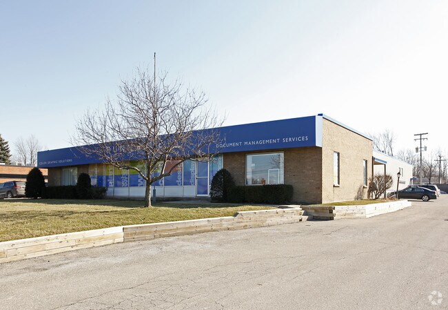
Property Record
1009 W Maple Rd, Clawson, MI 48017

Property Detail
1009 W Maple Rd
20-33-126-002
T2N, R11E, SEC 33 ASSESSOR'S PLAT NO. 3 LOT 4
Manufacturinglight
Oakland
BI
Michigan
B and X Area of moderate flood hazard, usually the area between the limits of the 100-year and 500-year floods.
4
2024
0.86 AC
2025
Troy Area West
180000
Detroit
11,912 SF
Detroit-Warren-Dearborn, MI
NEARBY LISTINGS FOR SALE OR LEASE
DEMOGRAPHICS near 1009 W Maple Rd
1 mile
3 mile
5 mile
2025 Total Population
12,113
101,026
279,574
2030 Population
12,424
103,096
284,405
Pop Growth 2025-2030
+ 2.57%
+ 2.05%
+ 1.73%
Average Age
40
41
42
2025 Total Households
5,840
46,253
118,524
HH Growth 2025-2030
+ 2.60%
+ 2.14%
+ 1.87%
Median Household Inc
$86,455
$96,102
$100,762
Avg Household Size
2.00
2.10
2.30
2025 Avg HH Vehicles
2.00
2.00
2.00
Median Home Value
$262,344
$349,001
$341,087
Median Year Built
1967
1965
1965
Nearby Places
Map Layers
Map Styles
 Street
 Aerial
Transit
 Traffic
 Biking
Places
Listings with unknown addresses are not visible on the map
- Restaurants
- Banks
- Shops
- Fitness
- Groceries
PUBLIC TRANSPORTATION
COMMUTER RAIL
Drive
Walk
Distance
5 min
1.9 mi
Drive
Walk
Distance
12 min
4.9 mi
AIRPORT
Windsor International
Drive
Walk
Distance
Windsor International
48 min
28.0 mi
Detroit Metro Wayne County
Drive
Walk
Distance
Detroit Metro Wayne County
53 min
37.5 mi
Nearby Properties
Address
Land Use
TOTAL SIZE
Lot Size
Zoning
Address
Land Use
TOTAL SIZE
Lot Size
Zoning
399,735 SF
19.71 AC
B2
Address
Land Use
TOTAL SIZE
Lot Size
Zoning
272,233 SF
90.90 AC
Address
Land Use
TOTAL SIZE
Lot Size
Zoning
224,766 SF
19.92 AC
B2
Address
Land Use
TOTAL SIZE
Lot Size
Zoning
300,925 SF
10.13 AC
Address
Land Use
TOTAL SIZE
Lot Size
Zoning
512,471 SF
21 AC
Address
Land Use
TOTAL SIZE
Lot Size
Zoning
512,475 SF
20.02 AC
Address
Land Use
TOTAL SIZE
Lot Size
Zoning
21.76 AC
Address
Land Use
TOTAL SIZE
Lot Size
Zoning
476,388 SF
23 AC
Address
Land Use
TOTAL SIZE
Lot Size
Zoning
15.32 AC
GEN BUS
Address
Land Use
TOTAL SIZE
Lot Size
Zoning
111,030 SF
0.97 AC
BI
Address
Land Use
TOTAL SIZE
Lot Size
Zoning
149,395 SF
1.02 AC
BI
Address
Land Use
TOTAL SIZE
Lot Size
Zoning
208,296 SF
8.16 AC
OSC
Address
Land Use
TOTAL SIZE
Lot Size
Zoning
157,500 SF
20.79 AC
OM
Address
Land Use
TOTAL SIZE
Lot Size
Zoning
272,233 SF
9.09 AC
OSC
Address
Land Use
TOTAL SIZE
Lot Size
Zoning
143,160 SF
0.84 AC
BI
Address
Land Use
TOTAL SIZE
Lot Size
Zoning
399,212 SF
26.18 AC
RM1
Address
Land Use
TOTAL SIZE
Lot Size
Zoning
236,140 SF
1.67 AC
BI
Address
Land Use
TOTAL SIZE
Lot Size
Zoning
136,672 SF
32 AC
Address
Land Use
TOTAL SIZE
Lot Size
Zoning
12.16 AC
PUD
Address
Land Use
TOTAL SIZE
Lot Size
Zoning
99,661 SF
0.62 AC
Address
Land Use
TOTAL SIZE
Lot Size
Zoning
427,945 SF
18.26 AC
OSC
Address
Land Use
TOTAL SIZE
Lot Size
Zoning
251,735 SF
10.57 AC
RM3
Address
Land Use
TOTAL SIZE
Lot Size
Zoning
250,868 SF
6 AC
OSC
Address
Land Use
TOTAL SIZE
Lot Size
Zoning
160,796 SF
1.84 AC
Address
Land Use
TOTAL SIZE
Lot Size
Zoning
362,816 SF
29 AC
Address
Land Use
TOTAL SIZE
Lot Size
Zoning
365,104 SF
2.03 AC
Address
Land Use
TOTAL SIZE
Lot Size
Zoning
300,925 SF
10.13 AC
OSC
Address
Land Use
TOTAL SIZE
Lot Size
Zoning
300,924 SF
10.13 AC
Address
Land Use
TOTAL SIZE
Lot Size
Zoning
301,728 SF
2.83 AC
B2
Address
Land Use
TOTAL SIZE
Lot Size
Zoning
119,732 SF
3.77 AC
The World's #1 Commercial Real Estate Marketplace
Connect with us
© 2026 CoStar Group
The information above has been obtained from sources believed reliable. While we do not doubt its accuracy we have not verified it and make no guarantee, warranty or representation about it. It is your responsibility to independently confirm its accuracy and completeness. Any projections, opinions, assumptions, or estimates used are for example only and do not represent the current or future performance of the property. The value of this transaction to you depends on tax and other factors which should be evaluated by your tax, financial, and legal advisors. You and your advisors should conduct a careful, independent investigation of the property to determine to your satisfaction the suitability of the property for your needs.