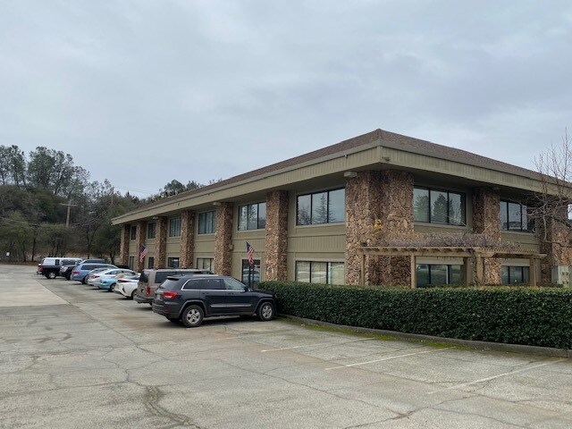
Property Record
10091 Streeter Rd, Auburn, CA 95602


Save to a Folder
{{folder.Name}}
{{folder.ListingIds.length}} Properties
{{folder.ListingIds.length}} Property
Create a New Folder
Property Detail
10091 Streeter Rd
057-210-005-000
PTN PCL A PM 15/109 & 28-14-8
Officebuilding
Nevada
BP-SC
California
B and X Area of moderate flood hazard, usually the area between the limits of the 100-year and 500-year floods.
a
2025
1.15 AC
2026
California North Rural Area
000105
Other Market Areas
12,695 SF
Truckee-Grass Valley, CA
NEARBY LISTINGS FOR SALE OR LEASE
-
-
View all Auburn listings for sale on LoopNet.com
DEMOGRAPHICS near 10091 Streeter Rd
1 mile
3 mile
5 mile
2025 Total Population
631
8,130
17,654
2030 Population
609
8,054
17,830
Pop Growth 2025-2030
(3.49%)
(0.93%)
+ 1.00%
Average Age
49
50
49
2025 Total Households
242
3,302
7,031
HH Growth 2025-2030
(3.31%)
(0.97%)
+ 0.92%
Median Household Inc
$69,886
$110,535
$108,283
Avg Household Size
2.60
2.40
2.50
2025 Avg HH Vehicles
3.00
2.00
3.00
Median Home Value
$821,428
$752,532
$735,859
Median Year Built
1988
1981
1981
Nearby Places
Map Layers
Map Styles
 Street
 Aerial
Layers
 Traffic
 Biking
Places
Listings with unknown addresses are not visible on the map
- Restaurants
- Banks
- Shops
- Fitness
- Groceries
SALE & LEASE HISTORY
LISTING DATE
SALE/LEASE

Jul 21, 2021
For Sale
Feb 25, 2020
For Lease
Nearby Properties
Address
Land Use
TOTAL SIZE
Lot Size
Zoning
Address
Land Use
TOTAL SIZE
Lot Size
Zoning
5.52 AC
Address
Land Use
TOTAL SIZE
Lot Size
Zoning
25,195 SF
3.20 AC
C2-SC-SP
Address
Land Use
TOTAL SIZE
Lot Size
Zoning
58,478 SF
5.31 AC
C1-SC-SP
Address
Land Use
TOTAL SIZE
Lot Size
Zoning
47,083 SF
11.43 AC
C2SCSP
Address
Land Use
TOTAL SIZE
Lot Size
Zoning
43,150 SF
5.61 AC
RA-1.5
Address
Land Use
TOTAL SIZE
Lot Size
Zoning
36,632 SF
11.99 AC
RA-5
Address
Land Use
TOTAL SIZE
Lot Size
Zoning
0.96 AC
Address
Land Use
TOTAL SIZE
Lot Size
Zoning
3,600 SF
170.26 AC
RECPDSP
Address
Land Use
TOTAL SIZE
Lot Size
Zoning
33,600 SF
6.39 AC
OSSC
Address
Land Use
TOTAL SIZE
Lot Size
Zoning
14,085 SF
1.58 AC
C2-SC-SP
Address
Land Use
TOTAL SIZE
Lot Size
Zoning
2,980 SF
1.34 AC
C2-SC-SP
Address
Land Use
TOTAL SIZE
Lot Size
Zoning
31,600 SF
1.93 AC
M1-SC-SP
Address
Land Use
TOTAL SIZE
Lot Size
Zoning
14,562 SF
3.75 AC
C1-SC-SP
Address
Land Use
TOTAL SIZE
Lot Size
Zoning
8,504 SF
1.23 AC
Address
Land Use
TOTAL SIZE
Lot Size
Zoning
3,351 SF
1.41 AC
C2-SC-SP
Address
Land Use
TOTAL SIZE
Lot Size
Zoning
30,520 SF
6.16 AC
BP-SC-SP
Address
Land Use
TOTAL SIZE
Lot Size
Zoning
3,192 SF
3.88 AC
C2-SC-SP
Address
Land Use
TOTAL SIZE
Lot Size
Zoning
8,000 SF
1.65 AC
M1-SC-SP
Address
Land Use
TOTAL SIZE
Lot Size
Zoning
1.95 AC
Address
Land Use
TOTAL SIZE
Lot Size
Zoning
3,584 SF
5.07 AC
RA-1.5
Address
Land Use
TOTAL SIZE
Lot Size
Zoning
102.17 AC
AG-10-PD
Address
Land Use
TOTAL SIZE
Lot Size
Zoning
82.04 AC
RA-3-PD
Address
Land Use
TOTAL SIZE
Lot Size
Zoning
4.12 AC
OS
Address
Land Use
TOTAL SIZE
Lot Size
Zoning
5,292 SF
35.50 AC
Address
Land Use
TOTAL SIZE
Lot Size
Zoning
2,500 SF
0.80 AC
C2-SC-SP
Address
Land Use
TOTAL SIZE
Lot Size
Zoning
23,374 SF
2.85 AC
BP-SC
Address
Land Use
TOTAL SIZE
Lot Size
Zoning
139.93 AC
AG-10-PD
Address
Land Use
TOTAL SIZE
Lot Size
Zoning
3,200 SF
3.82 AC
AG5SC
Address
Land Use
TOTAL SIZE
Lot Size
Zoning
The World's #1 Commercial Real Estate Marketplace
Connect with us
© 2026 CoStar Group
The information above has been obtained from sources believed reliable. While we do not doubt its accuracy we have not verified it and make no guarantee, warranty or representation about it. It is your responsibility to independently confirm its accuracy and completeness. Any projections, opinions, assumptions, or estimates used are for example only and do not represent the current or future performance of the property. The value of this transaction to you depends on tax and other factors which should be evaluated by your tax, financial, and legal advisors. You and your advisors should conduct a careful, independent investigation of the property to determine to your satisfaction the suitability of the property for your needs.