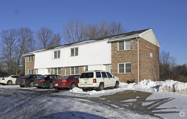
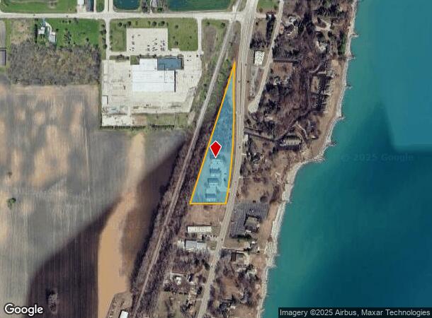
Property Record
101 2Nd Ln, Racine, WI 53403
NEARBY LISTINGS FOR SALE OR LEASE
-
-
View all Racine listings for sale on LoopNet.com
Property Detail
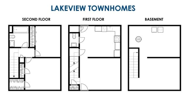
101 2Nd Ln
83-4-223-052-7017
PT N 1/4 SEC 5 T 2 R 23 COM W 1/4 COR SD SEC TH N 1098 FT E 1459.5 FT TO E LN MIL ELEC ROW & POB TH E 283.66 FT TO W LN HWY #
Commercialnec
Kenosha
X
Wisconsin
55059C0091E
0
2024
4.20 AC
2024
Outlying Kenosha County
000101
Chicago
4,108 SF
Chicago-Naperville-Elgin, IL-IN-WI
DEMOGRAPHICS near 101 2Nd Ln
1 Mile
3 Mile
5 Mile
2024 Total Population
1,278
30,616
101,257
2029 Population
1,269
30,305
100,548
Pop Growth 2024-2029
(0.70%)
(1.02%)
(0.70%)
Average Age
43
41
39
2024 Total Households
539
12,775
41,342
HH Growth 2024-2029
(0.74%)
(1.09%)
(0.72%)
Median Household Inc
$93,580
$67,058
$57,765
Avg Household Size
2.30
2.30
2.30
2024 Avg HH Vehicles
2.00
2.00
2.00
Median Home Value
$327,325
$191,342
$176,966
Median Year Built
1976
1968
1963
Nearby Places
Map Layers
Map Styles
 Street
 Aerial
- Restaurants
- Banks
- Shops
- Fitness
- Groceries
PUBLIC TRANSPORTATION
COMMUTER RAIL
Kenosha Station (Union Pacific North Line - Northeast Illinois Regional Commuter Railroad (Metra))
DRIVE
WALK
Distance
Kenosha Station (Union Pacific North Line - Northeast Illinois Regional Commuter Railroad (Metra))
11 min
5.8 mi
AIRPORT
General Mitchell International
DRIVE
WALK
Distance
General Mitchell International
40 min
28.6 mi
Freight Ports
Port Milwaukee
DRIVE
WALK
Distance
Port Milwaukee
45 min
32.5 mi
SALE & LEASE HISTORY
LISTING DATE
SALE/LEASE

Oct 09, 2020
For Sale
Nearby Properties
Address
Land Use
TOTAL SIZE
Lot Size
Zoning
Address
Land Use
TOTAL SIZE
Lot Size
Zoning
22.34 AC
Address
Land Use
TOTAL SIZE
Lot Size
Zoning
26,500 SF
17.79 AC
RM2
Address
Land Use
TOTAL SIZE
Lot Size
Zoning
33.40 AC
I2
Address
Land Use
TOTAL SIZE
Lot Size
Zoning
15,084 SF
34.20 AC
Address
Land Use
TOTAL SIZE
Lot Size
Zoning
98.81 AC
Address
Land Use
TOTAL SIZE
Lot Size
Zoning
11.56 AC
Address
Land Use
TOTAL SIZE
Lot Size
Zoning
102,312 SF
9.92 AC
B2
Address
Land Use
TOTAL SIZE
Lot Size
Zoning
105,550 SF
13.43 AC
Address
Land Use
TOTAL SIZE
Lot Size
Zoning
9,860 SF
14.55 AC
RM2
Address
Land Use
TOTAL SIZE
Lot Size
Zoning
Address
Land Use
TOTAL SIZE
Lot Size
Zoning
13,224 SF
8.88 AC
Address
Land Use
TOTAL SIZE
Lot Size
Zoning
10.12 AC
Address
Land Use
TOTAL SIZE
Lot Size
Zoning
Address
Land Use
TOTAL SIZE
Lot Size
Zoning
5.24 AC
Address
Land Use
TOTAL SIZE
Lot Size
Zoning
9,832 SF
2.65 AC
R4
Address
Land Use
TOTAL SIZE
Lot Size
Zoning
Address
Land Use
TOTAL SIZE
Lot Size
Zoning
14.94 AC
Address
Land Use
TOTAL SIZE
Lot Size
Zoning
12,420 SF
6.58 AC
RM2
Address
Land Use
TOTAL SIZE
Lot Size
Zoning
19.15 AC
Address
Land Use
TOTAL SIZE
Lot Size
Zoning
19.15 AC
Address
Land Use
TOTAL SIZE
Lot Size
Zoning
Address
Land Use
TOTAL SIZE
Lot Size
Zoning
18.93 AC
Address
Land Use
TOTAL SIZE
Lot Size
Zoning
13,224 SF
1.85 AC
B2
Address
Land Use
TOTAL SIZE
Lot Size
Zoning
72,940 SF
3.47 AC
R4
Address
Land Use
TOTAL SIZE
Lot Size
Zoning
Address
Land Use
TOTAL SIZE
Lot Size
Zoning
16,182 SF
3.39 AC
RM2
Address
Land Use
TOTAL SIZE
Lot Size
Zoning
12,321 SF
1.81 AC
Address
Land Use
TOTAL SIZE
Lot Size
Zoning
26,500 SF
2.81 AC
RM2
Address
Land Use
TOTAL SIZE
Lot Size
Zoning
15,652 SF
2.93 AC
R4
Address
Land Use
TOTAL SIZE
Lot Size
Zoning
13,224 SF
3.87 AC
The World's #1 Commercial Real Estate Marketplace
Connect with us
© 2025 CoStar Group
The information above has been obtained from sources believed reliable. While we do not doubt its accuracy we have not verified it and make no guarantee, warranty or representation about it. It is your responsibility to independently confirm its accuracy and completeness. Any projections, opinions, assumptions, or estimates used are for example only and do not represent the current or future performance of the property. The value of this transaction to you depends on tax and other factors which should be evaluated by your tax, financial, and legal advisors. You and your advisors should conduct a careful, independent investigation of the property to determine to your satisfaction the suitability of the property for your needs.