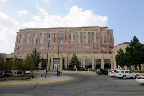
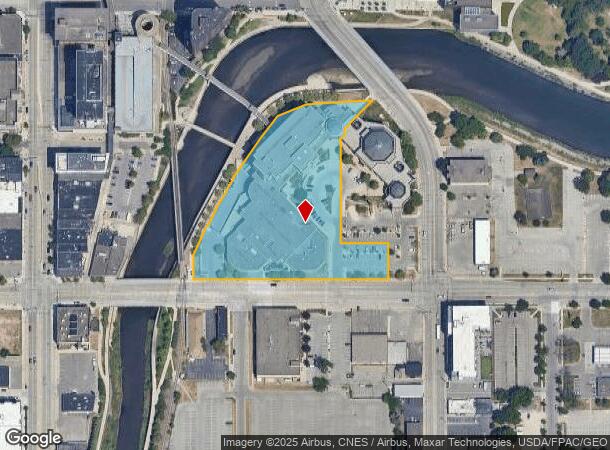
Property Record
101 4Th St Se, Rochester, MN 55904
NEARBY LISTINGS FOR SALE OR LEASE
Property Detail
101 4Th St Se
Rochester, MN
Government Center
64.02.11.053100
SECT-02 TWP-106 RANGE-014 GOVERNMENT CENTER LOT-001 BLOCK-001 LOT 1 BLK 1
Municipalproperty
Olmsted
X
Minnesota
27109C0164F
1
0
3.92 AC
2024
Downtown Rochester
000300
Other Market Areas
454,243 SF
DEMOGRAPHICS near 101 4Th St Se
1 Mile
3 Mile
5 Mile
2024 Total Population
15,837
76,631
117,513
2029 Population
16,428
78,715
120,491
Pop Growth 2024-2029
+ 3.73%
+ 2.72%
+ 2.53%
Average Age
40
40
40
2024 Total Households
7,974
33,019
48,937
HH Growth 2024-2029
+ 4.19%
+ 2.76%
+ 2.55%
Median Household Inc
$50,757
$72,677
$79,111
Avg Household Size
1.80
2.20
2.30
2024 Avg HH Vehicles
1.00
2.00
2.00
Median Home Value
$180,483
$263,158
$277,556
Median Year Built
1959
1977
1984
Nearby Places
Map Layers
Map Styles
 Street
 Aerial
- Restaurants
- Banks
- Shops
- Fitness
- Groceries
PUBLIC TRANSPORTATION
AIRPORT
Rochester International
DRIVE
WALK
Distance
Rochester International
14 min
8.4 mi
Freight Ports
Port Milwaukee
DRIVE
WALK
Distance
Port Milwaukee
307 min
276.6 mi
Nearby Properties
Address
Land Use
TOTAL SIZE
Lot Size
Zoning
Address
Land Use
TOTAL SIZE
Lot Size
Zoning
Address
Land Use
TOTAL SIZE
Lot Size
Zoning
2,238,362 SF
2.06 AC
Address
Land Use
TOTAL SIZE
Lot Size
Zoning
2.77 AC
Address
Land Use
TOTAL SIZE
Lot Size
Zoning
791,669 SF
2.15 AC
Address
Land Use
TOTAL SIZE
Lot Size
Zoning
37,242 SF
1.06 AC
Address
Land Use
TOTAL SIZE
Lot Size
Zoning
443,223 SF
4.44 AC
Address
Land Use
TOTAL SIZE
Lot Size
Zoning
448,296 SF
1.21 AC
Address
Land Use
TOTAL SIZE
Lot Size
Zoning
4,612 SF
21.16 AC
Address
Land Use
TOTAL SIZE
Lot Size
Zoning
960 SF
38.12 AC
Address
Land Use
TOTAL SIZE
Lot Size
Zoning
45.84 AC
Address
Land Use
TOTAL SIZE
Lot Size
Zoning
1,836 SF
80.90 AC
Address
Land Use
TOTAL SIZE
Lot Size
Zoning
339,724 SF
0.56 AC
Address
Land Use
TOTAL SIZE
Lot Size
Zoning
7,202 SF
52.44 AC
Address
Land Use
TOTAL SIZE
Lot Size
Zoning
0.88 AC
Address
Land Use
TOTAL SIZE
Lot Size
Zoning
576 SF
48.26 AC
Address
Land Use
TOTAL SIZE
Lot Size
Zoning
309,127 SF
0.67 AC
Address
Land Use
TOTAL SIZE
Lot Size
Zoning
175,078 SF
1.98 AC
Address
Land Use
TOTAL SIZE
Lot Size
Zoning
98,878 SF
0.89 AC
Address
Land Use
TOTAL SIZE
Lot Size
Zoning
76,338 SF
7.90 AC
Address
Land Use
TOTAL SIZE
Lot Size
Zoning
180,031 SF
2.96 AC
Address
Land Use
TOTAL SIZE
Lot Size
Zoning
159,238 SF
0.65 AC
Address
Land Use
TOTAL SIZE
Lot Size
Zoning
423,328 SF
1.89 AC
Address
Land Use
TOTAL SIZE
Lot Size
Zoning
192,929 SF
1.12 AC
Address
Land Use
TOTAL SIZE
Lot Size
Zoning
Address
Land Use
TOTAL SIZE
Lot Size
Zoning
210,691 SF
34.19 AC
Address
Land Use
TOTAL SIZE
Lot Size
Zoning
61,632 SF
53.25 AC
Address
Land Use
TOTAL SIZE
Lot Size
Zoning
190,062 SF
10.62 AC
Address
Land Use
TOTAL SIZE
Lot Size
Zoning
250,864 SF
4.43 AC
Address
Land Use
TOTAL SIZE
Lot Size
Zoning
9.01 AC
The World's #1 Commercial Real Estate Marketplace
Connect with us
© 2026 CoStar Group
The information above has been obtained from sources believed reliable. While we do not doubt its accuracy we have not verified it and make no guarantee, warranty or representation about it. It is your responsibility to independently confirm its accuracy and completeness. Any projections, opinions, assumptions, or estimates used are for example only and do not represent the current or future performance of the property. The value of this transaction to you depends on tax and other factors which should be evaluated by your tax, financial, and legal advisors. You and your advisors should conduct a careful, independent investigation of the property to determine to your satisfaction the suitability of the property for your needs.