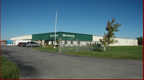
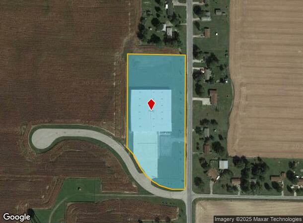
Property Record
101 Armstrong Way, Union City, OH 45390

NEARBY LISTINGS FOR SALE OR LEASE
Property Detail
101 Armstrong Way
H33-2-113-20-03-01-10201
PT SE1/4 SW1/4
Publicstorage
Darke
X
Ohio
18135C0185C
6.55 AC
2024
Ohio South Area
2024
Other Market Areas
510100
Greenville, OH
60,000 SF
DEMOGRAPHICS near 101 Armstrong Way
1 Mile
3 Mile
5 Mile
2024 Total Population
2,479
7,049
8,259
2029 Population
2,517
7,140
8,312
Pop Growth 2024-2029
+ 1.53%
+ 1.29%
+ 0.64%
Average Age
40
40
40
2024 Total Households
1,010
2,884
3,357
HH Growth 2024-2029
+ 1.29%
+ 1.21%
+ 0.57%
Median Household Inc
$42,074
$36,122
$38,728
Avg Household Size
2.30
2.30
2.40
2024 Avg HH Vehicles
2.00
2.00
2.00
Median Home Value
$62,526
$69,928
$78,163
Median Year Built
1950
1958
1959
Nearby Places
Map Layers
Map Styles
 Street
 Aerial
- Restaurants
- Banks
- Shops
- Fitness
- Groceries
SALE & LEASE HISTORY
LISTING DATE
SALE/LEASE

Sep 25, 2016
For Lease
Sep 24, 2016
For Sale
Apr 18, 2019
For Lease
Apr 18, 2019
For Sale
Nearby Properties
Address
Land Use
TOTAL SIZE
Lot Size
Zoning
Address
Land Use
TOTAL SIZE
Lot Size
Zoning
109,631 SF
14.30 AC
Address
Land Use
TOTAL SIZE
Lot Size
Zoning
206,300 SF
38.95 AC
M2
Address
Land Use
TOTAL SIZE
Lot Size
Zoning
75,000 SF
10.01 AC
Address
Land Use
TOTAL SIZE
Lot Size
Zoning
82,280 SF
0.68 AC
C2
Address
Land Use
TOTAL SIZE
Lot Size
Zoning
159,800 SF
46.01 AC
M2
Address
Land Use
TOTAL SIZE
Lot Size
Zoning
141,564 SF
31.25 AC
M2
Address
Land Use
TOTAL SIZE
Lot Size
Zoning
13,254 SF
3.99 AC
R2
Address
Land Use
TOTAL SIZE
Lot Size
Zoning
40,300 SF
10 AC
Address
Land Use
TOTAL SIZE
Lot Size
Zoning
370.27 AC
Address
Land Use
TOTAL SIZE
Lot Size
Zoning
21,280 SF
0.56 AC
C3
Address
Land Use
TOTAL SIZE
Lot Size
Zoning
33,001 SF
20.45 AC
Address
Land Use
TOTAL SIZE
Lot Size
Zoning
52,595 SF
8.10 AC
C3
Address
Land Use
TOTAL SIZE
Lot Size
Zoning
1,305 SF
158.50 AC
Address
Land Use
TOTAL SIZE
Lot Size
Zoning
22,657 SF
2.84 AC
R2
Address
Land Use
TOTAL SIZE
Lot Size
Zoning
249.33 AC
Address
Land Use
TOTAL SIZE
Lot Size
Zoning
Address
Land Use
TOTAL SIZE
Lot Size
Zoning
6,364 SF
2.07 AC
Address
Land Use
TOTAL SIZE
Lot Size
Zoning
11,768 SF
1.44 AC
C3
Address
Land Use
TOTAL SIZE
Lot Size
Zoning
1,056 SF
6.52 AC
M2
Address
Land Use
TOTAL SIZE
Lot Size
Zoning
10,000 SF
2.05 AC
C3
Address
Land Use
TOTAL SIZE
Lot Size
Zoning
9,000 SF
1.32 AC
Address
Land Use
TOTAL SIZE
Lot Size
Zoning
Address
Land Use
TOTAL SIZE
Lot Size
Zoning
740 SF
23.90 AC
C3
Address
Land Use
TOTAL SIZE
Lot Size
Zoning
188.24 AC
Address
Land Use
TOTAL SIZE
Lot Size
Zoning
9.17 AC
R1
Address
Land Use
TOTAL SIZE
Lot Size
Zoning
3,071 SF
76.81 AC
Address
Land Use
TOTAL SIZE
Lot Size
Zoning
2,120 SF
153.14 AC
Address
Land Use
TOTAL SIZE
Lot Size
Zoning
17,412 SF
2.83 AC
Address
Land Use
TOTAL SIZE
Lot Size
Zoning
25,523 SF
0.79 AC
R1
The World's #1 Commercial Real Estate Marketplace
Connect with us
© 2026 CoStar Group
The information above has been obtained from sources believed reliable. While we do not doubt its accuracy we have not verified it and make no guarantee, warranty or representation about it. It is your responsibility to independently confirm its accuracy and completeness. Any projections, opinions, assumptions, or estimates used are for example only and do not represent the current or future performance of the property. The value of this transaction to you depends on tax and other factors which should be evaluated by your tax, financial, and legal advisors. You and your advisors should conduct a careful, independent investigation of the property to determine to your satisfaction the suitability of the property for your needs.