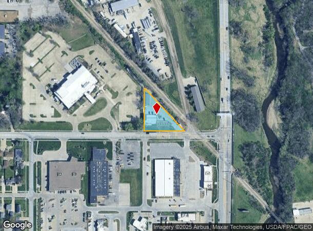
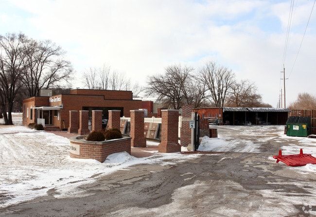
Property Record
101 Ashworth Rd, West Des Moines, IA 50265
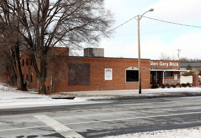

This Property Is For Sale
NEARBY LISTINGS FOR SALE OR LEASE
Property Detail
101 Ashworth Rd
Des Moines-West Des Moines, IA
Clegg Park Plat 4
320-00950000000
E 230 F MEAS ON S LINE LOT 169 CLEGG PARK PLAT 4
Officebuilding
Polk
X
Iowa
19153C0329F
169
2024
0.64 AC
2025
Western Suburbs
011111
Des Moines
4,644 SF
DEMOGRAPHICS near 101 Ashworth Rd
1 Mile
3 Mile
5 Mile
2024 Total Population
10,555
80,866
201,659
2029 Population
10,957
83,678
210,484
Pop Growth 2024-2029
+ 3.81%
+ 3.48%
+ 4.38%
Average Age
39
40
39
2024 Total Households
4,820
36,066
88,503
HH Growth 2024-2029
+ 3.92%
+ 3.68%
+ 4.71%
Median Household Inc
$63,730
$69,960
$68,055
Avg Household Size
2.10
2.20
2.20
2024 Avg HH Vehicles
2.00
2.00
2.00
Median Home Value
$218,993
$223,075
$222,243
Median Year Built
1957
1962
1972
Nearby Places
- Restaurants
- Banks
- Shops
- Fitness
- Groceries
PUBLIC TRANSPORTATION
AIRPORT
Des Moines International
DRIVE
WALK
Distance
Des Moines International
11 min
5.3 mi
Freight Ports
Port Milwaukee
DRIVE
WALK
Distance
Port Milwaukee
422 min
378.2 mi
Nearby Properties
Address
Land Use
TOTAL SIZE
Lot Size
Zoning
Address
Land Use
TOTAL SIZE
Lot Size
Zoning
594,010 SF
24.40 AC
R1-80
Address
Land Use
TOTAL SIZE
Lot Size
Zoning
339,258 SF
9.50 AC
R3
Address
Land Use
TOTAL SIZE
Lot Size
Zoning
289,527 SF
11.23 AC
PUD
Address
Land Use
TOTAL SIZE
Lot Size
Zoning
255,521 SF
60.90 AC
RE
Address
Land Use
TOTAL SIZE
Lot Size
Zoning
274,736 SF
10.27 AC
R-3
Address
Land Use
TOTAL SIZE
Lot Size
Zoning
415,320 SF
51.16 AC
PUD
Address
Land Use
TOTAL SIZE
Lot Size
Zoning
241,324 SF
21.67 AC
PUD B&C
Address
Land Use
TOTAL SIZE
Lot Size
Zoning
254,071 SF
9.17 AC
R3
Address
Land Use
TOTAL SIZE
Lot Size
Zoning
179,663 SF
2.27 AC
PUD
Address
Land Use
TOTAL SIZE
Lot Size
Zoning
244,212 SF
2.20 AC
NPC
Address
Land Use
TOTAL SIZE
Lot Size
Zoning
444,073 SF
28.05 AC
RH
Address
Land Use
TOTAL SIZE
Lot Size
Zoning
67,691 SF
7.30 AC
Address
Land Use
TOTAL SIZE
Lot Size
Zoning
195,931 SF
13.66 AC
Address
Land Use
TOTAL SIZE
Lot Size
Zoning
289,966 SF
8.57 AC
R-3
Address
Land Use
TOTAL SIZE
Lot Size
Zoning
203,710 SF
26.88 AC
Address
Land Use
TOTAL SIZE
Lot Size
Zoning
82,525 SF
0.97 AC
Address
Land Use
TOTAL SIZE
Lot Size
Zoning
96,450 SF
9.90 AC
R3
Address
Land Use
TOTAL SIZE
Lot Size
Zoning
308,117 SF
18.33 AC
RH
Address
Land Use
TOTAL SIZE
Lot Size
Zoning
150,640 SF
2.46 AC
PUD
Address
Land Use
TOTAL SIZE
Lot Size
Zoning
235,620 SF
13.18 AC
RH
Address
Land Use
TOTAL SIZE
Lot Size
Zoning
526,295 SF
26.06 AC
M-1
Address
Land Use
TOTAL SIZE
Lot Size
Zoning
1,164,314 SF
57.72 AC
RC
Address
Land Use
TOTAL SIZE
Lot Size
Zoning
117,272 SF
3.46 AC
R1-60
Address
Land Use
TOTAL SIZE
Lot Size
Zoning
298,528 SF
3.79 AC
R-4
Address
Land Use
TOTAL SIZE
Lot Size
Zoning
175,810 SF
19.36 AC
RC
Address
Land Use
TOTAL SIZE
Lot Size
Zoning
247,414 SF
15.83 AC
RH
Address
Land Use
TOTAL SIZE
Lot Size
Zoning
374,551 SF
9.37 AC
R-3
Address
Land Use
TOTAL SIZE
Lot Size
Zoning
122,676 SF
1.16 AC
Address
Land Use
TOTAL SIZE
Lot Size
Zoning
192,222 SF
9.27 AC
The World's #1 Commercial Real Estate Marketplace
Connect with us
© 2025 CoStar Group
The information above has been obtained from sources believed reliable. While we do not doubt its accuracy we have not verified it and make no guarantee, warranty or representation about it. It is your responsibility to independently confirm its accuracy and completeness. Any projections, opinions, assumptions, or estimates used are for example only and do not represent the current or future performance of the property. The value of this transaction to you depends on tax and other factors which should be evaluated by your tax, financial, and legal advisors. You and your advisors should conduct a careful, independent investigation of the property to determine to your satisfaction the suitability of the property for your needs.