Property Record
101 Beloit St, Walworth, WI 53184
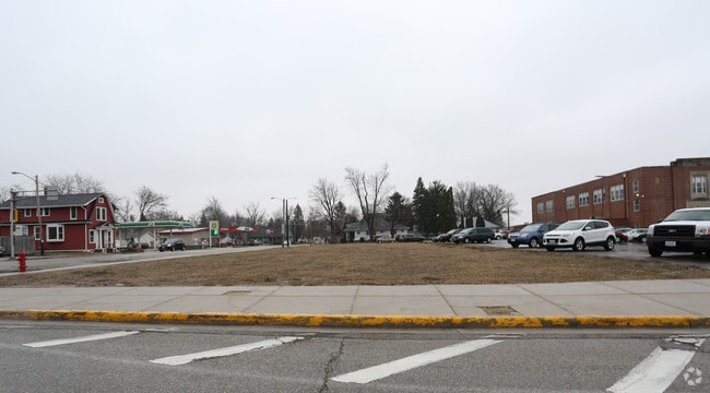

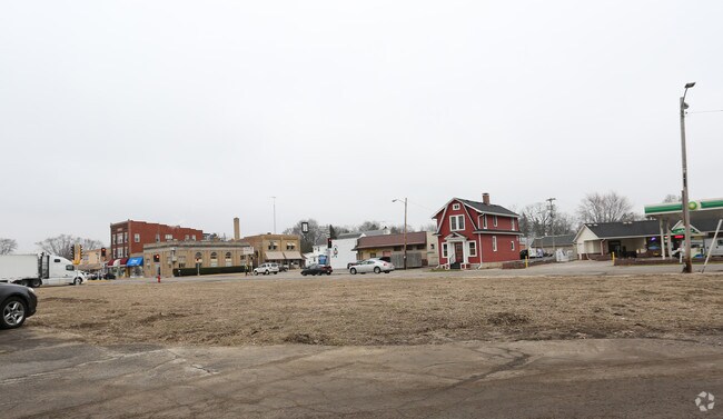
Property Detail
101 Beloit St
Whitewater-Elkhorn, WI
LOT 2 CERTIFIED SURVEY NO. 2936 AS RECORDED IN VOL 15 OF C.S. ON PAGE 209 WCR. LOCATED IN NE 1/4 SE 1/4 SEC 21 T1N R16E. 3059
VA293600002
WALWORTH
Stateproperty
Wisconsin
B and X Area of moderate flood hazard, usually the area between the limits of the 100-year and 500-year floods.
2
0
0.71 AC
2025
Walworth West
001608
Milwaukee/Madison
NEARBY LISTINGS FOR SALE OR LEASE
-
-
View all Walworth listings for sale on LoopNet.com
DEMOGRAPHICS near 101 Beloit St
1 mile
3 mile
5 mile
2025 Total Population
2,514
7,749
15,513
2030 Population
2,453
7,993
16,188
Pop Growth 2025-2030
(2.43%)
+ 3.15%
+ 4.35%
Average Age
41
42
44
2025 Total Households
1,014
2,971
6,274
HH Growth 2025-2030
(2.47%)
+ 4.71%
+ 5.23%
Median Household Inc
$65,603
$84,415
$76,741
Avg Household Size
2.40
2.30
2.30
2025 Avg HH Vehicles
2.00
2.00
2.00
Median Home Value
$301,914
$383,180
$377,548
Median Year Built
1970
1977
1976
Nearby Places
Map Layers
Map Styles
 Street
 Aerial
Layers
 Traffic
 Biking
Places
Listings with unknown addresses are not visible on the map
- Restaurants
- Banks
- Shops
- Fitness
- Groceries
PUBLIC TRANSPORTATION
COMMUTER RAIL
Harvard Station (Union Pacific Northwest Line - Northeast Illinois Regional Commuter Railroad (Metra))
Drive
Walk
Distance
Harvard Station (Union Pacific Northwest Line - Northeast Illinois Regional Commuter Railroad (Metra))
12 min
8.0 mi
Freight Ports
Port Milwaukee
Drive
Walk
Distance
Port Milwaukee
70 min
56.0 mi
Nearby Properties
Address
Land Use
TOTAL SIZE
Lot Size
Zoning
Address
Land Use
TOTAL SIZE
Lot Size
Zoning
175.60 AC
M1
Address
Land Use
TOTAL SIZE
Lot Size
Zoning
35.02 AC
Address
Land Use
TOTAL SIZE
Lot Size
Zoning
278.83 AC
Address
Land Use
TOTAL SIZE
Lot Size
Zoning
16.19 AC
Address
Land Use
TOTAL SIZE
Lot Size
Zoning
1.60 AC
Address
Land Use
TOTAL SIZE
Lot Size
Zoning
4.21 AC
Address
Land Use
TOTAL SIZE
Lot Size
Zoning
Address
Land Use
TOTAL SIZE
Lot Size
Zoning
161.01 AC
Address
Land Use
TOTAL SIZE
Lot Size
Zoning
13.01 AC
Address
Land Use
TOTAL SIZE
Lot Size
Zoning
33.99 AC
Address
Land Use
TOTAL SIZE
Lot Size
Zoning
4.89 AC
Address
Land Use
TOTAL SIZE
Lot Size
Zoning
Address
Land Use
TOTAL SIZE
Lot Size
Zoning
0.42 AC
Address
Land Use
TOTAL SIZE
Lot Size
Zoning
7.06 AC
Address
Land Use
TOTAL SIZE
Lot Size
Zoning
0.42 AC
Address
Land Use
TOTAL SIZE
Lot Size
Zoning
Address
Land Use
TOTAL SIZE
Lot Size
Zoning
23.02 AC
Address
Land Use
TOTAL SIZE
Lot Size
Zoning
Address
Land Use
TOTAL SIZE
Lot Size
Zoning
3.80 AC
Address
Land Use
TOTAL SIZE
Lot Size
Zoning
0.83 AC
Address
Land Use
TOTAL SIZE
Lot Size
Zoning
0.83 AC
Address
Land Use
TOTAL SIZE
Lot Size
Zoning
0.56 AC
Address
Land Use
TOTAL SIZE
Lot Size
Zoning
13.67 AC
Address
Land Use
TOTAL SIZE
Lot Size
Zoning
5.51 AC
Address
Land Use
TOTAL SIZE
Lot Size
Zoning
10.90 AC
M1
Address
Land Use
TOTAL SIZE
Lot Size
Zoning
0.26 AC
Address
Land Use
TOTAL SIZE
Lot Size
Zoning
2.88 AC
Address
Land Use
TOTAL SIZE
Lot Size
Zoning
0.26 AC
Address
Land Use
TOTAL SIZE
Lot Size
Zoning
0.64 AC
Address
Land Use
TOTAL SIZE
Lot Size
Zoning
1.75 AC
The World's #1 Commercial Real Estate Marketplace
Connect with us
© 2026 CoStar Group
The information above has been obtained from sources believed reliable. While we do not doubt its accuracy we have not verified it and make no guarantee, warranty or representation about it. It is your responsibility to independently confirm its accuracy and completeness. Any projections, opinions, assumptions, or estimates used are for example only and do not represent the current or future performance of the property. The value of this transaction to you depends on tax and other factors which should be evaluated by your tax, financial, and legal advisors. You and your advisors should conduct a careful, independent investigation of the property to determine to your satisfaction the suitability of the property for your needs.