Property Record
101 Brenwood St, Berea, KY 40403

Save to a Folder
{{folder.Name}}
{{folder.ListingIds.length}} Properties
{{folder.ListingIds.length}} Property
Create a New Folder
Property Detail
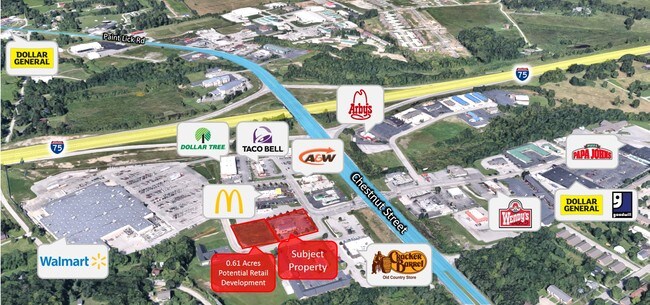
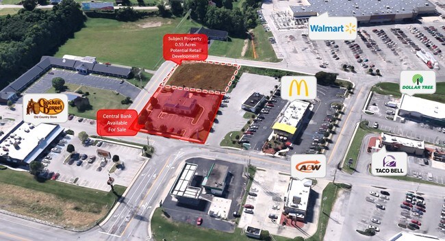
101 Brenwood St
Richmond-Berea, KY
CENTRAL BANK BUILDING
B002-0003-0002
MADISON
Professionalbldglegalinsurancerealestateetc
Kentucky
B and X Area of moderate flood hazard, usually the area between the limits of the 100-year and 500-year floods.
0.73 AC
2025
Georgetown/Richmond Area
2025
Other Market Areas
011301
NEARBY LISTINGS FOR SALE OR LEASE
-
-
No Photo
-
View all Berea listings for sale on LoopNet.com
DEMOGRAPHICS near 101 Brenwood St
1 mile
3 mile
5 mile
2025 Total Population
4,637
19,597
25,025
2030 Population
4,899
20,776
26,522
Pop Growth 2025-2030
+ 5.65%
+ 6.02%
+ 5.98%
Average Age
37
38
38
2025 Total Households
1,955
7,606
9,662
HH Growth 2025-2030
+ 5.98%
+ 6.48%
+ 6.40%
Median Household Inc
$56,255
$61,796
$62,906
Avg Household Size
2.30
2.40
2.40
2025 Avg HH Vehicles
2.00
2.00
2.00
Median Home Value
$187,532
$206,919
$213,055
Median Year Built
1990
1990
1991
Nearby Places
Map Layers
Map Styles
 Street
 Aerial
Layers
 Traffic
 Biking
Places
Listings with unknown addresses are not visible on the map
- Restaurants
- Banks
- Shops
- Fitness
- Groceries
SALE & LEASE HISTORY
LISTING DATE
SALE/LEASE

Feb 19, 2019
For Sale
Apr 17, 2019
For Sale
Nearby Properties
Address
Land Use
TOTAL SIZE
Lot Size
Zoning
Address
Land Use
TOTAL SIZE
Lot Size
Zoning
586,836 SF
40.67 AC
Address
Land Use
TOTAL SIZE
Lot Size
Zoning
Address
Land Use
TOTAL SIZE
Lot Size
Zoning
16,800 SF
41.52 AC
Address
Land Use
TOTAL SIZE
Lot Size
Zoning
151,767 SF
11.50 AC
Address
Land Use
TOTAL SIZE
Lot Size
Zoning
181,450 SF
48.71 AC
Address
Land Use
TOTAL SIZE
Lot Size
Zoning
11,500 SF
53.96 AC
Address
Land Use
TOTAL SIZE
Lot Size
Zoning
Address
Land Use
TOTAL SIZE
Lot Size
Zoning
Address
Land Use
TOTAL SIZE
Lot Size
Zoning
239,769 SF
46.50 AC
Address
Land Use
TOTAL SIZE
Lot Size
Zoning
18,056 SF
2.71 AC
Address
Land Use
TOTAL SIZE
Lot Size
Zoning
288,350 SF
27.61 AC
Address
Land Use
TOTAL SIZE
Lot Size
Zoning
0.90 AC
Address
Land Use
TOTAL SIZE
Lot Size
Zoning
2.20 AC
Address
Land Use
TOTAL SIZE
Lot Size
Zoning
3.10 AC
Address
Land Use
TOTAL SIZE
Lot Size
Zoning
41,112 SF
1.90 AC
Address
Land Use
TOTAL SIZE
Lot Size
Zoning
78,511 SF
10.45 AC
Address
Land Use
TOTAL SIZE
Lot Size
Zoning
41,418 SF
7.16 AC
Address
Land Use
TOTAL SIZE
Lot Size
Zoning
1.62 AC
Address
Land Use
TOTAL SIZE
Lot Size
Zoning
25,270 SF
2.80 AC
Address
Land Use
TOTAL SIZE
Lot Size
Zoning
29,878 SF
1.20 AC
Address
Land Use
TOTAL SIZE
Lot Size
Zoning
0.86 AC
Address
Land Use
TOTAL SIZE
Lot Size
Zoning
3,146 SF
0.27 AC
Address
Land Use
TOTAL SIZE
Lot Size
Zoning
10,027 SF
2.10 AC
Address
Land Use
TOTAL SIZE
Lot Size
Zoning
6,240 SF
3.71 AC
Address
Land Use
TOTAL SIZE
Lot Size
Zoning
1.55 AC
Address
Land Use
TOTAL SIZE
Lot Size
Zoning
4,800 SF
1.19 AC
Address
Land Use
TOTAL SIZE
Lot Size
Zoning
29,005 SF
5.17 AC
Address
Land Use
TOTAL SIZE
Lot Size
Zoning
4,220 SF
0.99 AC
Address
Land Use
TOTAL SIZE
Lot Size
Zoning
1,272 SF
3.11 AC
Address
Land Use
TOTAL SIZE
Lot Size
Zoning
10,523 SF
0.25 AC
The World's #1 Commercial Real Estate Marketplace
Connect with us
© 2026 CoStar Group
The information above has been obtained from sources believed reliable. While we do not doubt its accuracy we have not verified it and make no guarantee, warranty or representation about it. It is your responsibility to independently confirm its accuracy and completeness. Any projections, opinions, assumptions, or estimates used are for example only and do not represent the current or future performance of the property. The value of this transaction to you depends on tax and other factors which should be evaluated by your tax, financial, and legal advisors. You and your advisors should conduct a careful, independent investigation of the property to determine to your satisfaction the suitability of the property for your needs.