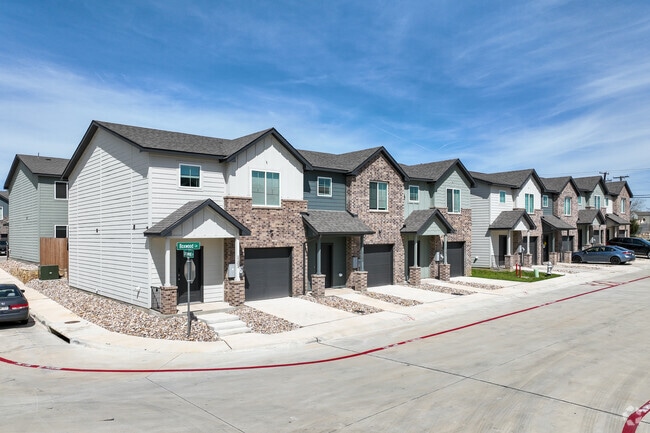
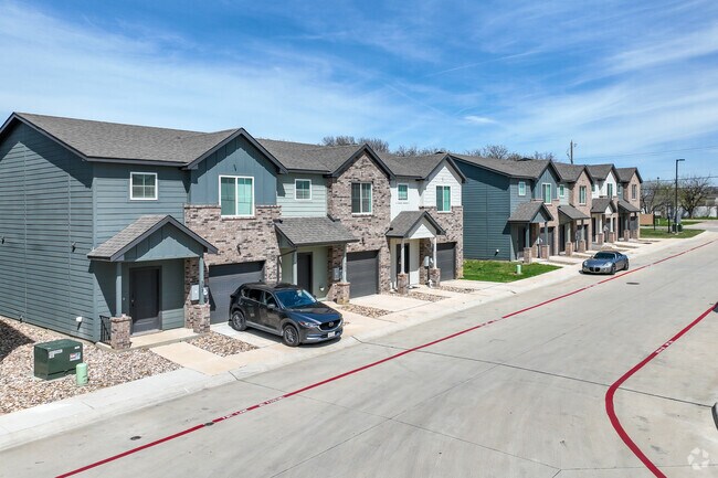
Property Record
101 Briarwood Dr, Fort Worth, TX 76140
Save to a Folder
{{folder.Name}}
{{folder.ListingIds.length}} Properties
{{folder.ListingIds.length}} Property
Create a New Folder
Property Detail
101 Briarwood Dr
Dallas-Fort Worth-Arlington, TX
WOODS, THE BLOCK 1 LOT 24
42738375
TARRANT
Multifamilydwelling
Texas
B and X Area of moderate flood hazard, usually the area between the limits of the 100-year and 500-year floods.
24
2025
0.25 AC
2025
South Fort Worth
111102
Dallas/Ft Worth
5,192 SF
NEARBY LISTINGS FOR SALE OR LEASE
-
-
View all Fort Worth listings for sale on LoopNet.com
DEMOGRAPHICS near 101 Briarwood Dr
1 mile
3 mile
5 mile
2025 Total Population
7,756
63,553
193,991
2030 Population
8,206
66,904
204,428
Pop Growth 2025-2030
+ 5.80%
+ 5.27%
+ 5.38%
Average Age
37
37
37
2025 Total Households
2,604
20,896
63,641
HH Growth 2025-2030
+ 6.03%
+ 5.47%
+ 5.51%
Median Household Inc
$60,157
$65,817
$67,011
Avg Household Size
2.90
3.00
2.90
2025 Avg HH Vehicles
2.00
2.00
2.00
Median Home Value
$167,127
$231,548
$249,402
Median Year Built
1975
1982
1980
Nearby Places
Map Layers
Map Styles
 Street
 Aerial
Layers
 Traffic
 Biking
Places
Listings with unknown addresses are not visible on the map
- Restaurants
- Banks
- Shops
- Fitness
- Groceries
PUBLIC TRANSPORTATION
AIRPORT
Dallas-Fort Worth International
Drive
Walk
Distance
Dallas-Fort Worth International
37 min
27.7 mi
Dallas Love Field
Drive
Walk
Distance
Dallas Love Field
47 min
37.5 mi
Freight Ports
Port of Shreveport
Drive
Walk
Distance
Port of Shreveport
238 min
223.2 mi
Nearby Properties
Address
Land Use
TOTAL SIZE
Lot Size
Zoning
Address
Land Use
TOTAL SIZE
Lot Size
Zoning
593,917 SF
45.85 AC
Address
Land Use
TOTAL SIZE
Lot Size
Zoning
605,489 SF
35.12 AC
Address
Land Use
TOTAL SIZE
Lot Size
Zoning
615,054 SF
27.49 AC
Address
Land Use
TOTAL SIZE
Lot Size
Zoning
488,564 SF
29.43 AC
Address
Land Use
TOTAL SIZE
Lot Size
Zoning
181,611 SF
24.44 AC
Address
Land Use
TOTAL SIZE
Lot Size
Zoning
224,000 SF
24.35 AC
Address
Land Use
TOTAL SIZE
Lot Size
Zoning
487,507 SF
145.80 AC
Address
Land Use
TOTAL SIZE
Lot Size
Zoning
391,540 SF
21.17 AC
Address
Land Use
TOTAL SIZE
Lot Size
Zoning
186,894 SF
10.85 AC
Address
Land Use
TOTAL SIZE
Lot Size
Zoning
225,567 SF
13.01 AC
Address
Land Use
TOTAL SIZE
Lot Size
Zoning
353,875 SF
18.48 AC
Address
Land Use
TOTAL SIZE
Lot Size
Zoning
169,837 SF
9.44 AC
Address
Land Use
TOTAL SIZE
Lot Size
Zoning
327,530 SF
23.12 AC
Address
Land Use
TOTAL SIZE
Lot Size
Zoning
180,556 SF
11.78 AC
Address
Land Use
TOTAL SIZE
Lot Size
Zoning
141,411 SF
32.16 AC
Address
Land Use
TOTAL SIZE
Lot Size
Zoning
147,822 SF
9.45 AC
Address
Land Use
TOTAL SIZE
Lot Size
Zoning
124,224 SF
20.67 AC
Address
Land Use
TOTAL SIZE
Lot Size
Zoning
290,660 SF
19.16 AC
Address
Land Use
TOTAL SIZE
Lot Size
Zoning
193,290 SF
10.56 AC
Address
Land Use
TOTAL SIZE
Lot Size
Zoning
239,360 SF
17.55 AC
Address
Land Use
TOTAL SIZE
Lot Size
Zoning
259,449 SF
24 AC
Address
Land Use
TOTAL SIZE
Lot Size
Zoning
159,030 SF
10.32 AC
Address
Land Use
TOTAL SIZE
Lot Size
Zoning
142,110 SF
7.40 AC
Address
Land Use
TOTAL SIZE
Lot Size
Zoning
171,684 SF
8.12 AC
Address
Land Use
TOTAL SIZE
Lot Size
Zoning
4,886 SF
45.16 AC
Address
Land Use
TOTAL SIZE
Lot Size
Zoning
255,568 SF
14.79 AC
Address
Land Use
TOTAL SIZE
Lot Size
Zoning
498,850 SF
27.65 AC
Address
Land Use
TOTAL SIZE
Lot Size
Zoning
4,888 SF
31.18 AC
Address
Land Use
TOTAL SIZE
Lot Size
Zoning
187,500 SF
11.08 AC
Address
Land Use
TOTAL SIZE
Lot Size
Zoning
187,500 SF
11.08 AC
The World's #1 Commercial Real Estate Marketplace
Connect with us
© 2026 CoStar Group
The information above has been obtained from sources believed reliable. While we do not doubt its accuracy we have not verified it and make no guarantee, warranty or representation about it. It is your responsibility to independently confirm its accuracy and completeness. Any projections, opinions, assumptions, or estimates used are for example only and do not represent the current or future performance of the property. The value of this transaction to you depends on tax and other factors which should be evaluated by your tax, financial, and legal advisors. You and your advisors should conduct a careful, independent investigation of the property to determine to your satisfaction the suitability of the property for your needs.