Property Record
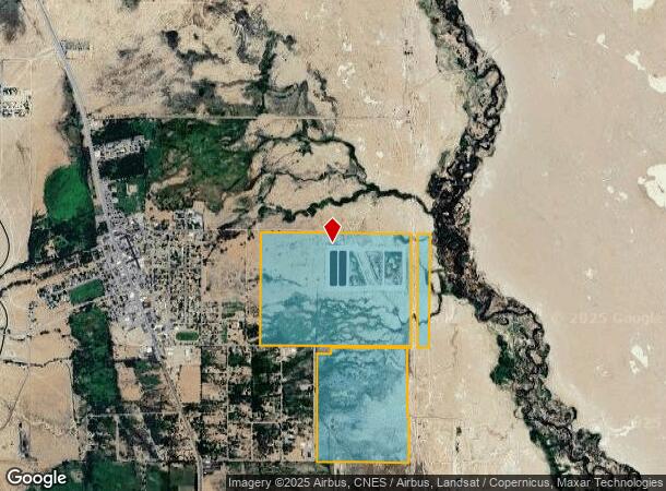
Sub-Station Rd, Lone Pine, CA 93545
NEARBY LISTINGS FOR SALE OR LEASE
-
-
View all Lone Pine listings for sale on LoopNet.com
Property Detail
Sub-Station Rd
026-060-15
POR SEC 27 T15SR36E SUBJ TO 10 ESMT
Agriculturalland
Inyo
X
California
06027C2200D
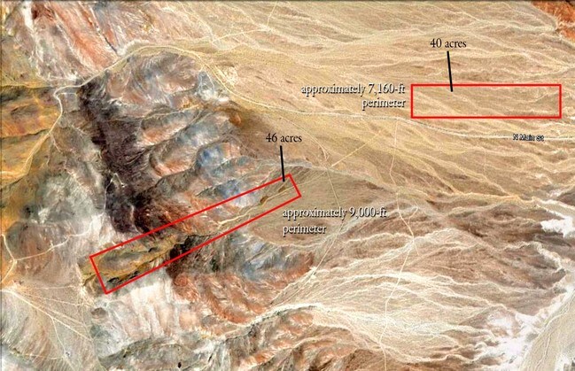
362.35 AC
2024
Tulare/Visalia
2025
Other Market Areas
000800
Bishop, CA
DEMOGRAPHICS near Sub-Station Rd
1 mile
3 mile
5 mile
2024 Total Population
297
1,226
1,558
2029 Population
273
1,127
1,432
Pop Growth 2024-2029
(8.08%)
(8.08%)
(8.09%)
Average Age
44
44
45
2024 Total Households
124
517
669
HH Growth 2024-2029
(8.87%)
(8.51%)
(8.52%)
Median Household Inc
$35,937
$35,156
$34,582
Avg Household Size
2.30
2.30
2.30
2024 Avg HH Vehicles
2.00
2.00
2.00
Median Home Value
$359,090
$368,367
$360,294
Median Year Built
1952
1954
1957
Nearby Places
Map Layers
Map Styles
 Street
 Aerial
Transit
 Traffic
 Biking
Places
Listings with unknown addresses are not visible on the map
- Restaurants
- Banks
- Shops
- Fitness
- Groceries
SALE & LEASE HISTORY
LISTING DATE
SALE/LEASE

Jun 05, 2017
For Sale
Jun 02, 2017
For Sale
Apr 03, 2017
For Sale
Nearby Properties
Address
Land Use
TOTAL SIZE
Lot Size
Zoning
Address
Land Use
TOTAL SIZE
Lot Size
Zoning
Address
Land Use
TOTAL SIZE
Lot Size
Zoning
Address
Land Use
TOTAL SIZE
Lot Size
Zoning
Address
Land Use
TOTAL SIZE
Lot Size
Zoning
Address
Land Use
TOTAL SIZE
Lot Size
Zoning
245.13 AC
Address
Land Use
TOTAL SIZE
Lot Size
Zoning
288.66 AC
Address
Land Use
TOTAL SIZE
Lot Size
Zoning
68.88 AC
Address
Land Use
TOTAL SIZE
Lot Size
Zoning
11,964 SF
1.78 AC
Address
Land Use
TOTAL SIZE
Lot Size
Zoning
22.50 AC
Address
Land Use
TOTAL SIZE
Lot Size
Zoning
1,741 SF
1 AC
Address
Land Use
TOTAL SIZE
Lot Size
Zoning
154.01 AC
Address
Land Use
TOTAL SIZE
Lot Size
Zoning
70,745 SF
2.61 AC
Address
Land Use
TOTAL SIZE
Lot Size
Zoning
640 AC
Address
Land Use
TOTAL SIZE
Lot Size
Zoning
Address
Land Use
TOTAL SIZE
Lot Size
Zoning
Address
Land Use
TOTAL SIZE
Lot Size
Zoning
1,732 SF
2.52 AC
Address
Land Use
TOTAL SIZE
Lot Size
Zoning
Address
Land Use
TOTAL SIZE
Lot Size
Zoning
398.40 AC
Address
Land Use
TOTAL SIZE
Lot Size
Zoning
Address
Land Use
TOTAL SIZE
Lot Size
Zoning
301.82 AC
Address
Land Use
TOTAL SIZE
Lot Size
Zoning
6.75 AC
Address
Land Use
TOTAL SIZE
Lot Size
Zoning
Address
Land Use
TOTAL SIZE
Lot Size
Zoning
25,879 SF
1.50 AC
Address
Land Use
TOTAL SIZE
Lot Size
Zoning
Address
Land Use
TOTAL SIZE
Lot Size
Zoning
640 AC
Address
Land Use
TOTAL SIZE
Lot Size
Zoning
3,547 SF
0.65 AC
Address
Land Use
TOTAL SIZE
Lot Size
Zoning
480 AC
Address
Land Use
TOTAL SIZE
Lot Size
Zoning
640 AC
Address
Land Use
TOTAL SIZE
Lot Size
Zoning
640 AC
The World's #1 Commercial Real Estate Marketplace
Connect with us
© 2026 CoStar Group
The information above has been obtained from sources believed reliable. While we do not doubt its accuracy we have not verified it and make no guarantee, warranty or representation about it. It is your responsibility to independently confirm its accuracy and completeness. Any projections, opinions, assumptions, or estimates used are for example only and do not represent the current or future performance of the property. The value of this transaction to you depends on tax and other factors which should be evaluated by your tax, financial, and legal advisors. You and your advisors should conduct a careful, independent investigation of the property to determine to your satisfaction the suitability of the property for your needs.