Property Record
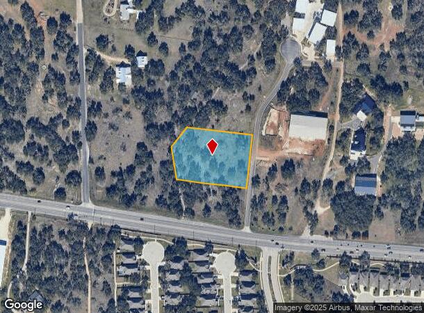
101 Cantera Way, Georgetown, TX 78628

Property Detail
101 Cantera Way
Austin-Round Rock-San Marcos, TX
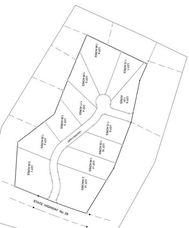
4400 West Llc Sub
R513787
S10187 - 4400 WEST LLC SUB, BLOCK 1, LOT 1, ACRES 2.11
Commercialacreage
Williamson
X
Texas
48491C0275E
1
2024
2.11 AC
2025
Georgetown
020122
Austin
NEARBY LISTINGS FOR SALE OR LEASE
DEMOGRAPHICS near 101 Cantera Way
1 mile
3 mile
5 mile
2024 Total Population
1,473
10,887
64,355
2029 Population
1,932
14,330
82,875
Pop Growth 2024-2029
+ 31.16%
+ 31.62%
+ 28.78%
Average Age
46
42
41
2024 Total Households
558
4,068
24,641
HH Growth 2024-2029
+ 31.72%
+ 32.08%
+ 29.30%
Median Household Inc
$166,495
$164,555
$116,998
Avg Household Size
2.70
2.70
2.60
2024 Avg HH Vehicles
2.00
2.00
2.00
Median Home Value
$580,492
$632,493
$490,562
Median Year Built
2011
2011
2010
Nearby Places
Map Layers
Map Styles
 Street
 Aerial
Transit
 Traffic
 Biking
Places
Listings with unknown addresses are not visible on the map
- Restaurants
- Banks
- Shops
- Fitness
- Groceries
PUBLIC TRANSPORTATION
AIRPORT
Austin-Bergstrom International
Drive
Walk
Distance
Austin-Bergstrom International
56 min
41.3 mi
Robert Gray AAF
Drive
Walk
Distance
Robert Gray AAF
56 min
41.7 mi
Killeen Municipal
Drive
Walk
Distance
Killeen Municipal
59 min
47.4 mi
SALE & LEASE HISTORY
LISTING DATE
SALE/LEASE

Jul 26, 2019
For Sale
Nearby Properties
Address
Land Use
TOTAL SIZE
Lot Size
Zoning
Address
Land Use
TOTAL SIZE
Lot Size
Zoning
393,202 SF
15.42 AC
Address
Land Use
TOTAL SIZE
Lot Size
Zoning
272,531 SF
14.97 AC
Address
Land Use
TOTAL SIZE
Lot Size
Zoning
40,042 SF
19.78 AC
Address
Land Use
TOTAL SIZE
Lot Size
Zoning
53,794 SF
19.77 AC
Address
Land Use
TOTAL SIZE
Lot Size
Zoning
125,929 SF
2.18 AC
Address
Land Use
TOTAL SIZE
Lot Size
Zoning
Address
Land Use
TOTAL SIZE
Lot Size
Zoning
72,199 SF
7.85 AC
Address
Land Use
TOTAL SIZE
Lot Size
Zoning
20,206 SF
18.52 AC
Address
Land Use
TOTAL SIZE
Lot Size
Zoning
32,092 SF
0.14 AC
Address
Land Use
TOTAL SIZE
Lot Size
Zoning
61,130 SF
7.71 AC
Address
Land Use
TOTAL SIZE
Lot Size
Zoning
1,508 SF
7.01 AC
Address
Land Use
TOTAL SIZE
Lot Size
Zoning
7,918 SF
12.56 AC
Address
Land Use
TOTAL SIZE
Lot Size
Zoning
17,032 SF
3.65 AC
Address
Land Use
TOTAL SIZE
Lot Size
Zoning
3,237 SF
81.23 AC
Address
Land Use
TOTAL SIZE
Lot Size
Zoning
11,129 SF
19.47 AC
Address
Land Use
TOTAL SIZE
Lot Size
Zoning
7,180 SF
4.72 AC
Address
Land Use
TOTAL SIZE
Lot Size
Zoning
8,010 SF
5.08 AC
Address
Land Use
TOTAL SIZE
Lot Size
Zoning
13,710 SF
3.65 AC
Address
Land Use
TOTAL SIZE
Lot Size
Zoning
4,698 SF
1.50 AC
Address
Land Use
TOTAL SIZE
Lot Size
Zoning
7,870 SF
4.28 AC
Address
Land Use
TOTAL SIZE
Lot Size
Zoning
14,614 SF
33.52 AC
Address
Land Use
TOTAL SIZE
Lot Size
Zoning
8,215 SF
3.53 AC
Address
Land Use
TOTAL SIZE
Lot Size
Zoning
8,626 SF
1.14 AC
Address
Land Use
TOTAL SIZE
Lot Size
Zoning
32,092 SF
14.05 AC
Address
Land Use
TOTAL SIZE
Lot Size
Zoning
7,082 SF
2.69 AC
Address
Land Use
TOTAL SIZE
Lot Size
Zoning
7,634 SF
0.72 AC
Address
Land Use
TOTAL SIZE
Lot Size
Zoning
17,426 SF
2.46 AC
Address
Land Use
TOTAL SIZE
Lot Size
Zoning
10.02 AC
Address
Land Use
TOTAL SIZE
Lot Size
Zoning
7,518 SF
2.87 AC
Address
Land Use
TOTAL SIZE
Lot Size
Zoning
The World's #1 Commercial Real Estate Marketplace
Connect with us
© 2026 CoStar Group
The information above has been obtained from sources believed reliable. While we do not doubt its accuracy we have not verified it and make no guarantee, warranty or representation about it. It is your responsibility to independently confirm its accuracy and completeness. Any projections, opinions, assumptions, or estimates used are for example only and do not represent the current or future performance of the property. The value of this transaction to you depends on tax and other factors which should be evaluated by your tax, financial, and legal advisors. You and your advisors should conduct a careful, independent investigation of the property to determine to your satisfaction the suitability of the property for your needs.