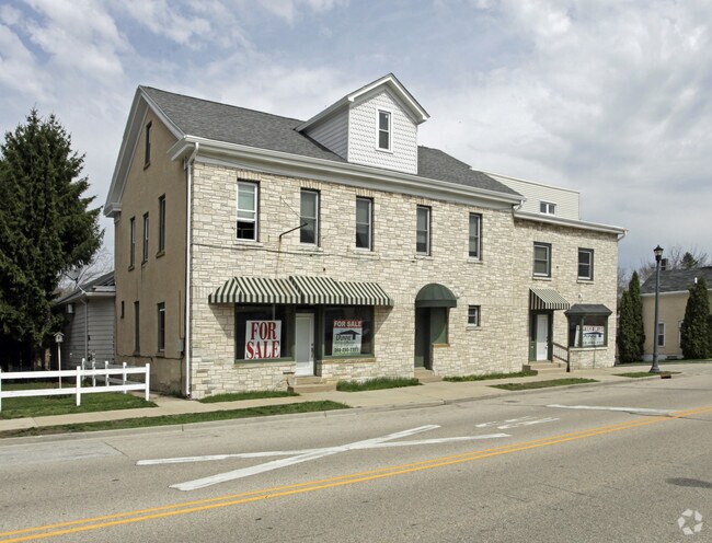
Property Record
101 Chestnut St S, Slinger, WI 53086


Save to a Folder
{{folder.Name}}
{{folder.ListingIds.length}} Properties
{{folder.ListingIds.length}} Property
Create a New Folder
Property Detail
101 Chestnut St S
Milwaukee-Waukesha, WI
V SLINGER FIRST ADDN PT OF LOT 1+2 BLK 6 ADDN TO 1ST ADDN PT OF LOT 12 BLK 6 DOC 1432997
V5-0072
WASHINGTON
Commercialnec
Wisconsin
B and X Area of moderate flood hazard, usually the area between the limits of the 100-year and 500-year floods.
1,12
2025
0.27 AC
2025
Washington West
450106
Milwaukee/Madison
3,343 SF
NEARBY LISTINGS FOR SALE OR LEASE
DEMOGRAPHICS near 101 Chestnut St S
1 mile
3 mile
5 mile
2025 Total Population
3,684
11,771
31,208
2030 Population
3,711
12,024
31,906
Pop Growth 2025-2030
+ 0.73%
+ 2.15%
+ 2.24%
Average Age
41
42
43
2025 Total Households
1,528
4,617
12,752
HH Growth 2025-2030
+ 0.72%
+ 2.01%
+ 2.16%
Median Household Inc
$103,087
$106,026
$91,812
Avg Household Size
2.40
2.50
2.40
2025 Avg HH Vehicles
2.00
2.00
2.00
Median Home Value
$364,697
$404,396
$368,129
Median Year Built
1991
1993
1990
Nearby Places
Map Layers
Map Styles
 Street
 Aerial
Layers
 Traffic
 Biking
Places
Listings with unknown addresses are not visible on the map
- Restaurants
- Banks
- Shops
- Fitness
- Groceries
SALE & LEASE HISTORY
LISTING DATE
SALE/LEASE

Sep 23, 2016
For Sale
Dec 19, 2018
For Lease
Nearby Properties
Address
Land Use
TOTAL SIZE
Lot Size
Zoning
Address
Land Use
TOTAL SIZE
Lot Size
Zoning
Address
Land Use
TOTAL SIZE
Lot Size
Zoning
Address
Land Use
TOTAL SIZE
Lot Size
Zoning
16.35 AC
Address
Land Use
TOTAL SIZE
Lot Size
Zoning
10,500 SF
4.83 AC
Address
Land Use
TOTAL SIZE
Lot Size
Zoning
4.74 AC
Address
Land Use
TOTAL SIZE
Lot Size
Zoning
Address
Land Use
TOTAL SIZE
Lot Size
Zoning
11,143 SF
9.23 AC
Address
Land Use
TOTAL SIZE
Lot Size
Zoning
5,335 SF
6.69 AC
Address
Land Use
TOTAL SIZE
Lot Size
Zoning
11,143 SF
6 AC
Address
Land Use
TOTAL SIZE
Lot Size
Zoning
Address
Land Use
TOTAL SIZE
Lot Size
Zoning
Address
Land Use
TOTAL SIZE
Lot Size
Zoning
Address
Land Use
TOTAL SIZE
Lot Size
Zoning
Address
Land Use
TOTAL SIZE
Lot Size
Zoning
13,506 SF
1.38 AC
Address
Land Use
TOTAL SIZE
Lot Size
Zoning
8.28 AC
Address
Land Use
TOTAL SIZE
Lot Size
Zoning
11,143 SF
1.85 AC
Address
Land Use
TOTAL SIZE
Lot Size
Zoning
6,334 SF
2.86 AC
Address
Land Use
TOTAL SIZE
Lot Size
Zoning
12,781 SF
1.68 AC
Address
Land Use
TOTAL SIZE
Lot Size
Zoning
8.20 AC
Address
Land Use
TOTAL SIZE
Lot Size
Zoning
10,870 SF
2.99 AC
Address
Land Use
TOTAL SIZE
Lot Size
Zoning
7.49 AC
Address
Land Use
TOTAL SIZE
Lot Size
Zoning
1,404 SF
8 AC
Address
Land Use
TOTAL SIZE
Lot Size
Zoning
Address
Land Use
TOTAL SIZE
Lot Size
Zoning
6,654 SF
2.91 AC
Address
Land Use
TOTAL SIZE
Lot Size
Zoning
5,335 SF
2.05 AC
Address
Land Use
TOTAL SIZE
Lot Size
Zoning
46.13 AC
Address
Land Use
TOTAL SIZE
Lot Size
Zoning
5,335 SF
4.02 AC
Address
Land Use
TOTAL SIZE
Lot Size
Zoning
13.31 AC
Address
Land Use
TOTAL SIZE
Lot Size
Zoning
Address
Land Use
TOTAL SIZE
Lot Size
Zoning
37.08 AC
The World's #1 Commercial Real Estate Marketplace
Connect with us
© 2026 CoStar Group
The information above has been obtained from sources believed reliable. While we do not doubt its accuracy we have not verified it and make no guarantee, warranty or representation about it. It is your responsibility to independently confirm its accuracy and completeness. Any projections, opinions, assumptions, or estimates used are for example only and do not represent the current or future performance of the property. The value of this transaction to you depends on tax and other factors which should be evaluated by your tax, financial, and legal advisors. You and your advisors should conduct a careful, independent investigation of the property to determine to your satisfaction the suitability of the property for your needs.