Property Record
101 Clay Ridge Ct, High Ridge, MO 63049


NEARBY LISTINGS FOR SALE OR LEASE
-
-
View all High Ridge listings for sale on LoopNet.com
Property Detail
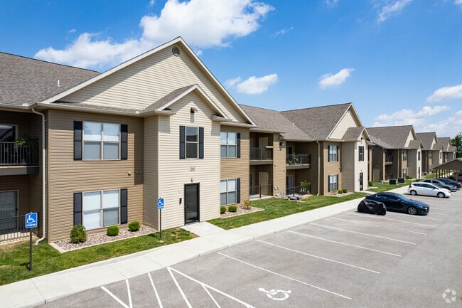
101 Clay Ridge Ct
St. Louis, MO-IL
Sugar Creek Apartments
02-3.0-05.0-6-003-002
SUGAR CREEK APARTMENTS LOT 2
Apartment
Jefferson
X
Missouri
29099C0101F
2
2024
16.34 AC
2025
Murphy
700306
St. Louis
258,312 SF
DEMOGRAPHICS near 101 Clay Ridge Ct
1 Mile
3 Mile
5 Mile
2024 Total Population
5,936
45,875
77,124
2029 Population
6,108
46,275
77,833
Pop Growth 2024-2029
+ 2.90%
+ 0.87%
+ 0.92%
Average Age
42
41
41
2024 Total Households
2,462
17,681
30,206
HH Growth 2024-2029
+ 2.88%
+ 1.02%
+ 0.99%
Median Household Inc
$67,354
$81,867
$81,475
Avg Household Size
2.40
2.50
2.50
2024 Avg HH Vehicles
2.00
2.00
2.00
Median Home Value
$185,058
$244,043
$246,353
Median Year Built
1979
1985
1985
Nearby Places
Map Layers
Map Styles
 Street
 Aerial
- Restaurants
- Banks
- Shops
- Fitness
- Groceries
PUBLIC TRANSPORTATION
AIRPORT
St Louis Lambert International
DRIVE
WALK
Distance
St Louis Lambert International
39 min
26.3 mi
Freight Ports
Tulsa Port of Inola
DRIVE
WALK
Distance
Tulsa Port of Inola
409 min
369.7 mi
Nearby Properties
Address
Land Use
TOTAL SIZE
Lot Size
Zoning
Address
Land Use
TOTAL SIZE
Lot Size
Zoning
429,212 SF
53.13 AC
C-8
Address
Land Use
TOTAL SIZE
Lot Size
Zoning
62.50 AC
NU
Address
Land Use
TOTAL SIZE
Lot Size
Zoning
139,212 SF
15.58 AC
21C-1
Address
Land Use
TOTAL SIZE
Lot Size
Zoning
112,840 SF
0.54 AC
C-8
Address
Land Use
TOTAL SIZE
Lot Size
Zoning
26.56 AC
NU
Address
Land Use
TOTAL SIZE
Lot Size
Zoning
129,090 SF
17.78 AC
21C-1
Address
Land Use
TOTAL SIZE
Lot Size
Zoning
211,612 SF
41.36 AC
PB
Address
Land Use
TOTAL SIZE
Lot Size
Zoning
265,291 SF
14.91 AC
PR2
Address
Land Use
TOTAL SIZE
Lot Size
Zoning
118,820 SF
13.30 AC
Address
Land Use
TOTAL SIZE
Lot Size
Zoning
156,592 SF
9.80 AC
PR2
Address
Land Use
TOTAL SIZE
Lot Size
Zoning
155,242 SF
22.76 AC
R09
Address
Land Use
TOTAL SIZE
Lot Size
Zoning
108,535 SF
14.09 AC
PUD
Address
Land Use
TOTAL SIZE
Lot Size
Zoning
134,885 SF
16.91 AC
21C-1
Address
Land Use
TOTAL SIZE
Lot Size
Zoning
54,348 SF
6.61 AC
C-8
Address
Land Use
TOTAL SIZE
Lot Size
Zoning
125,762 SF
10.42 AC
21C-1
Address
Land Use
TOTAL SIZE
Lot Size
Zoning
85,150 SF
8.62 AC
21R-6A
Address
Land Use
TOTAL SIZE
Lot Size
Zoning
7.41 AC
R3
Address
Land Use
TOTAL SIZE
Lot Size
Zoning
88,379 SF
8.97 AC
C-8
Address
Land Use
TOTAL SIZE
Lot Size
Zoning
41,284 SF
5.25 AC
Address
Land Use
TOTAL SIZE
Lot Size
Zoning
71,437 SF
5.88 AC
21C-3
Address
Land Use
TOTAL SIZE
Lot Size
Zoning
30,302 SF
3.71 AC
21C-2
Address
Land Use
TOTAL SIZE
Lot Size
Zoning
9.03 AC
R3
Address
Land Use
TOTAL SIZE
Lot Size
Zoning
83,960 SF
7.18 AC
21C-1
Address
Land Use
TOTAL SIZE
Lot Size
Zoning
10.64 AC
21R-1
Address
Land Use
TOTAL SIZE
Lot Size
Zoning
5.98 AC
21IP-1
Address
Land Use
TOTAL SIZE
Lot Size
Zoning
95,200 SF
11.61 AC
21C-1
Address
Land Use
TOTAL SIZE
Lot Size
Zoning
29,432 SF
1.92 AC
21C-1
Address
Land Use
TOTAL SIZE
Lot Size
Zoning
33,250 SF
0.47 AC
C-8
Address
Land Use
TOTAL SIZE
Lot Size
Zoning
104,892 SF
8.11 AC
The World's #1 Commercial Real Estate Marketplace
Connect with us
© 2025 CoStar Group
The information above has been obtained from sources believed reliable. While we do not doubt its accuracy we have not verified it and make no guarantee, warranty or representation about it. It is your responsibility to independently confirm its accuracy and completeness. Any projections, opinions, assumptions, or estimates used are for example only and do not represent the current or future performance of the property. The value of this transaction to you depends on tax and other factors which should be evaluated by your tax, financial, and legal advisors. You and your advisors should conduct a careful, independent investigation of the property to determine to your satisfaction the suitability of the property for your needs.