Property Record
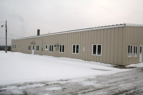
101 Coldbrook Rd, Hampden, ME 04444

Property Detail
101 Coldbrook Rd
HAMN-000022-000000-000004-000001
Penobscot
Industrialgeneral
Maine
33 - C
4-1
AE The base floodplain where base flood elevations are provided. AE Zones are now used on new format FIRMs instead of A1-A30 Zones.
43 AC
2025
Maine North & Bangor
2025
Other Market Areas
002000
Bangor, ME
19,112 SF
NEARBY LISTINGS FOR SALE OR LEASE
-
-
View all Hampden listings for sale on LoopNet.com
DEMOGRAPHICS near 101 Coldbrook Rd
1 mile
3 mile
5 mile
2025 Total Population
2,004
7,543
29,696
2030 Population
2,034
7,636
30,386
Pop Growth 2025-2030
+ 1.50%
+ 1.23%
+ 2.32%
Average Age
43
43
43
2025 Total Households
788
3,069
13,303
HH Growth 2025-2030
+ 1.78%
+ 1.40%
+ 2.53%
Median Household Inc
$106,775
$102,346
$68,382
Avg Household Size
2.40
2.40
2.10
2025 Avg HH Vehicles
2.00
2.00
2.00
Median Home Value
$305,118
$316,833
$267,252
Median Year Built
1990
1986
1967
Nearby Places
Map Layers
Map Styles
 Street
 Aerial
Layers
 Traffic
 Biking
Places
Listings with unknown addresses are not visible on the map
- Restaurants
- Banks
- Shops
- Fitness
- Groceries
PUBLIC TRANSPORTATION
AIRPORT
Bangor International
Drive
Walk
Distance
Bangor International
14 min
7.1 mi
Freight Ports
Searsport, ME
Drive
Walk
Distance
Searsport, ME
52 min
23.9 mi
Nearby Properties
Address
Land Use
TOTAL SIZE
Lot Size
Zoning
Address
Land Use
TOTAL SIZE
Lot Size
Zoning
54,122 SF
82.18 AC
12 - R
Address
Land Use
TOTAL SIZE
Lot Size
Zoning
184,000 SF
16.43 AC
31 - I
Address
Land Use
TOTAL SIZE
Lot Size
Zoning
144,000 SF
111.04 AC
32 - I
Address
Land Use
TOTAL SIZE
Lot Size
Zoning
61,870 SF
9.20 AC
12 - R
Address
Land Use
TOTAL SIZE
Lot Size
Zoning
13.58 AC
INDUST
Address
Land Use
TOTAL SIZE
Lot Size
Zoning
Address
Land Use
TOTAL SIZE
Lot Size
Zoning
66,333 SF
5.31 AC
GC&S
Address
Land Use
TOTAL SIZE
Lot Size
Zoning
186,836 SF
24.53 AC
UID
Address
Land Use
TOTAL SIZE
Lot Size
Zoning
134,304 SF
11.12 AC
INDUST
Address
Land Use
TOTAL SIZE
Lot Size
Zoning
4.23 AC
31 - I
Address
Land Use
TOTAL SIZE
Lot Size
Zoning
38,280 SF
13 AC
31 - I
Address
Land Use
TOTAL SIZE
Lot Size
Zoning
64,704 SF
3.27 AC
GC&S
Address
Land Use
TOTAL SIZE
Lot Size
Zoning
46,653 SF
3.95 AC
GC&S
Address
Land Use
TOTAL SIZE
Lot Size
Zoning
18,744 SF
43.50 AC
12 - R
Address
Land Use
TOTAL SIZE
Lot Size
Zoning
71,637 SF
4.77 AC
GC&S
Address
Land Use
TOTAL SIZE
Lot Size
Zoning
97,590 SF
11.77 AC
GC&S
Address
Land Use
TOTAL SIZE
Lot Size
Zoning
20,247 SF
7.87 AC
22 - B
Address
Land Use
TOTAL SIZE
Lot Size
Zoning
52.50 AC
INDUST
Address
Land Use
TOTAL SIZE
Lot Size
Zoning
2.65 AC
31 - I
Address
Land Use
TOTAL SIZE
Lot Size
Zoning
Address
Land Use
TOTAL SIZE
Lot Size
Zoning
28,600 SF
4 AC
22 - B
Address
Land Use
TOTAL SIZE
Lot Size
Zoning
49,283 SF
6.26 AC
UID
Address
Land Use
TOTAL SIZE
Lot Size
Zoning
25,988 SF
2.45 AC
20 - T
Address
Land Use
TOTAL SIZE
Lot Size
Zoning
35,970 SF
7.50 AC
33 - C
Address
Land Use
TOTAL SIZE
Lot Size
Zoning
28.61 AC
INDUST
Address
Land Use
TOTAL SIZE
Lot Size
Zoning
1.47 AC
31 - I
Address
Land Use
TOTAL SIZE
Lot Size
Zoning
42,900 SF
8.80 AC
31 - I
Address
Land Use
TOTAL SIZE
Lot Size
Zoning
33,504 SF
4.30 AC
GC&S
Address
Land Use
TOTAL SIZE
Lot Size
Zoning
39,972 SF
17 AC
I&S
Address
Land Use
TOTAL SIZE
Lot Size
Zoning
14,630 SF
4.27 AC
22 - B
The World's #1 Commercial Real Estate Marketplace
Connect with us
© 2026 CoStar Group
The information above has been obtained from sources believed reliable. While we do not doubt its accuracy we have not verified it and make no guarantee, warranty or representation about it. It is your responsibility to independently confirm its accuracy and completeness. Any projections, opinions, assumptions, or estimates used are for example only and do not represent the current or future performance of the property. The value of this transaction to you depends on tax and other factors which should be evaluated by your tax, financial, and legal advisors. You and your advisors should conduct a careful, independent investigation of the property to determine to your satisfaction the suitability of the property for your needs.