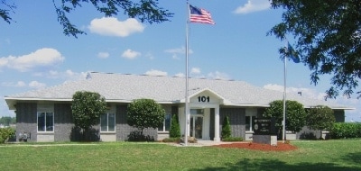
Property Record
101 Constellation Way N, Syracuse, NY 13212
NEARBY LISTINGS FOR SALE OR LEASE
Property Detail
101 Constellation Way N
314889-058-000-0001-010-000-0004
STATE POLICE BARRACKS LEASED LAND 0580122
Professionalbldglegalinsurancerealestateetc
Onondaga
X
New York
36067C0226F
10.000
2025
0.01 AC
2024
SE Outer Onondaga County
014400
Syracuse
6,120 SF
Syracuse, NY
DEMOGRAPHICS near 101 Constellation Way N
1 Mile
3 Mile
5 Mile
2024 Total Population
1,043
46,827
154,115
2029 Population
1,017
45,490
150,165
Pop Growth 2024-2029
(2.49%)
(2.86%)
(2.56%)
Average Age
41
43
40
2024 Total Households
445
20,517
68,048
HH Growth 2024-2029
(2.70%)
(3.05%)
(2.60%)
Median Household Inc
$67,361
$64,047
$56,708
Avg Household Size
2.20
2.20
2.20
2024 Avg HH Vehicles
2.00
2.00
1.00
Median Home Value
$116,234
$142,103
$146,901
Median Year Built
1953
1957
1958
Nearby Places
- Restaurants
- Banks
- Shops
- Fitness
- Groceries
PUBLIC TRANSPORTATION
COMMUTER RAIL
DRIVE
WALK
Distance
11 min
6.2 mi
DRIVE
WALK
Distance
11 min
6.2 mi
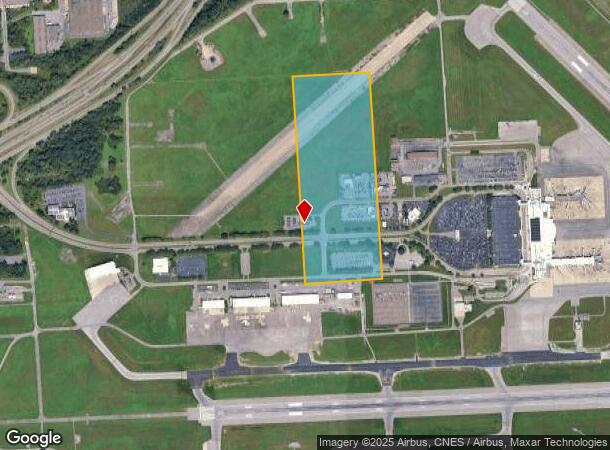
AIRPORT
Syracuse Hancock International
DRIVE
WALK
Distance
Syracuse Hancock International
3 min
0.6 mi
Nearby Properties
Address
Land Use
TOTAL SIZE
Lot Size
Zoning
Address
Land Use
TOTAL SIZE
Lot Size
Zoning
439,670 SF
74.73 AC
C-G
Address
Land Use
TOTAL SIZE
Lot Size
Zoning
432,246 SF
37.21 AC
05 - COMME
Address
Land Use
TOTAL SIZE
Lot Size
Zoning
22.16 AC
06 - INDUS
Address
Land Use
TOTAL SIZE
Lot Size
Zoning
11,484 SF
16.36 AC
03 - MULTI
Address
Land Use
TOTAL SIZE
Lot Size
Zoning
110,105 SF
26.68 AC
06 - INDUS
Address
Land Use
TOTAL SIZE
Lot Size
Zoning
218,439 SF
18.85 AC
Address
Land Use
TOTAL SIZE
Lot Size
Zoning
2,025 SF
267.94 AC
06 - INDUS
Address
Land Use
TOTAL SIZE
Lot Size
Zoning
165,954 SF
10.66 AC
06 - INDUS
Address
Land Use
TOTAL SIZE
Lot Size
Zoning
246,172 SF
16.65 AC
Address
Land Use
TOTAL SIZE
Lot Size
Zoning
32,840 SF
26.60 AC
05 - COMME
Address
Land Use
TOTAL SIZE
Lot Size
Zoning
110,811 SF
11.46 AC
06 - INDUS
Address
Land Use
TOTAL SIZE
Lot Size
Zoning
84,048 SF
19.42 AC
Address
Land Use
TOTAL SIZE
Lot Size
Zoning
169,511 SF
4.25 AC
01 - NOT Z
Address
Land Use
TOTAL SIZE
Lot Size
Zoning
206,807 SF
46 AC
06 - INDUS
Address
Land Use
TOTAL SIZE
Lot Size
Zoning
125,684 SF
25.61 AC
06 - INDUS
Address
Land Use
TOTAL SIZE
Lot Size
Zoning
3.59 AC
04 - FARM
Address
Land Use
TOTAL SIZE
Lot Size
Zoning
92,538 SF
19.96 AC
06 - INDUS
Address
Land Use
TOTAL SIZE
Lot Size
Zoning
120,068 SF
9.26 AC
GCPLUS
Address
Land Use
TOTAL SIZE
Lot Size
Zoning
78,656 SF
9.14 AC
06 - INDUS
Address
Land Use
TOTAL SIZE
Lot Size
Zoning
141,472 SF
12.38 AC
C-G
Address
Land Use
TOTAL SIZE
Lot Size
Zoning
92,844 SF
14.26 AC
C-G
Address
Land Use
TOTAL SIZE
Lot Size
Zoning
296.49 AC
06 - INDUS
Address
Land Use
TOTAL SIZE
Lot Size
Zoning
115,096 SF
10.29 AC
06 - INDUS
Address
Land Use
TOTAL SIZE
Lot Size
Zoning
118,651 SF
12.27 AC
02 - SINGL
Address
Land Use
TOTAL SIZE
Lot Size
Zoning
27,618 SF
24.05 AC
06 - INDUS
Address
Land Use
TOTAL SIZE
Lot Size
Zoning
103,005 SF
12.58 AC
Address
Land Use
TOTAL SIZE
Lot Size
Zoning
27,044 SF
25.20 AC
C-G
Address
Land Use
TOTAL SIZE
Lot Size
Zoning
257,680 SF
10.22 AC
06 - INDUS
Address
Land Use
TOTAL SIZE
Lot Size
Zoning
63,140 SF
25.52 AC
The World's #1 Commercial Real Estate Marketplace
Connect with us
© 2025 CoStar Group
The information above has been obtained from sources believed reliable. While we do not doubt its accuracy we have not verified it and make no guarantee, warranty or representation about it. It is your responsibility to independently confirm its accuracy and completeness. Any projections, opinions, assumptions, or estimates used are for example only and do not represent the current or future performance of the property. The value of this transaction to you depends on tax and other factors which should be evaluated by your tax, financial, and legal advisors. You and your advisors should conduct a careful, independent investigation of the property to determine to your satisfaction the suitability of the property for your needs.