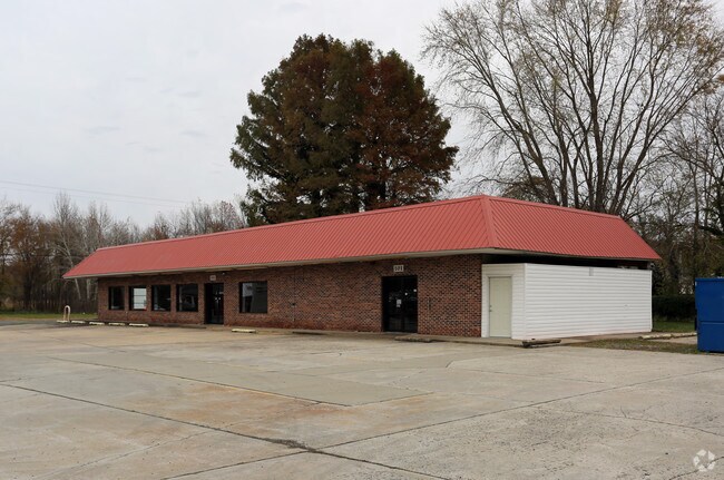
Property Record
101 Drummer Dr, Grasonville, MD 21638


NEARBY LISTINGS FOR SALE OR LEASE
Property Detail
101 Drummer Dr
Baltimore-Columbia-Towson, MD
Winchester Estates
05-004705
LOT 1-COMMERCIAL LOT W/EVANS AVE GRASONVILLE
Medicalbuilding
Queen Annes
X
Maryland
24035C0330D
1
2025
0.61 AC
2025
Queen Anne's County
810700
Baltimore
618 SF
DEMOGRAPHICS near 101 Drummer Dr
1 Mile
3 Mile
5 Mile
2024 Total Population
2,429
6,165
12,502
2029 Population
2,635
6,713
13,646
Pop Growth 2024-2029
+ 8.48%
+ 8.89%
+ 9.15%
Average Age
41
43
44
2024 Total Households
932
2,401
5,001
HH Growth 2024-2029
+ 8.48%
+ 8.87%
+ 9.10%
Median Household Inc
$108,223
$109,547
$105,600
Avg Household Size
2.60
2.50
2.50
2024 Avg HH Vehicles
2.00
2.00
2.00
Median Home Value
$426,235
$447,202
$456,842
Median Year Built
1990
1988
1988
Nearby Places
Map Layers
Map Styles
 Street
 Aerial
- Restaurants
- Banks
- Shops
- Fitness
- Groceries
PUBLIC TRANSPORTATION
AIRPORT
Baltimore/Washington International Thurgood Marshall
DRIVE
WALK
Distance
Baltimore/Washington International Thurgood Marshall
58 min
37.6 mi
Freight Ports
Port of Baltimore
DRIVE
WALK
Distance
Port of Baltimore
65 min
39.4 mi
SALE & LEASE HISTORY
LISTING DATE
SALE/LEASE

May 16, 2017
For Sale
May 01, 2017
For Sale
Nearby Properties
Address
Land Use
TOTAL SIZE
Lot Size
Zoning
Address
Land Use
TOTAL SIZE
Lot Size
Zoning
12,950 SF
8.72 AC
SC
Address
Land Use
TOTAL SIZE
Lot Size
Zoning
86,117 SF
1.67 AC
WVC
Address
Land Use
TOTAL SIZE
Lot Size
Zoning
69,030 SF
15 AC
SC
Address
Land Use
TOTAL SIZE
Lot Size
Zoning
9,330 SF
710.48 AC
CS
Address
Land Use
TOTAL SIZE
Lot Size
Zoning
1,504 SF
42.74 AC
WVC
Address
Land Use
TOTAL SIZE
Lot Size
Zoning
50,866 SF
4.37 AC
GGMS
Address
Land Use
TOTAL SIZE
Lot Size
Zoning
60,756 SF
3.57 AC
SE
Address
Land Use
TOTAL SIZE
Lot Size
Zoning
40,500 SF
6.47 AC
WVC
Address
Land Use
TOTAL SIZE
Lot Size
Zoning
65,108 SF
2.72 AC
WVC
Address
Land Use
TOTAL SIZE
Lot Size
Zoning
53,927 SF
18.74 AC
SR
Address
Land Use
TOTAL SIZE
Lot Size
Zoning
1,740 SF
100 AC
CS
Address
Land Use
TOTAL SIZE
Lot Size
Zoning
16,442 SF
3.77 AC
SE
Address
Land Use
TOTAL SIZE
Lot Size
Zoning
37,800 SF
6.60 AC
WVC
Address
Land Use
TOTAL SIZE
Lot Size
Zoning
41,888 SF
4.41 AC
WVC
Address
Land Use
TOTAL SIZE
Lot Size
Zoning
3,716 SF
19.15 AC
SI
Address
Land Use
TOTAL SIZE
Lot Size
Zoning
1,488 SF
12.59 AC
WVC
Address
Land Use
TOTAL SIZE
Lot Size
Zoning
9,092 SF
10 AC
WVC
Address
Land Use
TOTAL SIZE
Lot Size
Zoning
4,800 SF
5 AC
UC
Address
Land Use
TOTAL SIZE
Lot Size
Zoning
45,960 SF
3.43 AC
UC
Address
Land Use
TOTAL SIZE
Lot Size
Zoning
12,800 SF
3.68 AC
WVC
Address
Land Use
TOTAL SIZE
Lot Size
Zoning
2,592 SF
6.31 AC
GVC
Address
Land Use
TOTAL SIZE
Lot Size
Zoning
44,390 SF
0.85 AC
GGMS
Address
Land Use
TOTAL SIZE
Lot Size
Zoning
21,882 SF
2.18 AC
UC
Address
Land Use
TOTAL SIZE
Lot Size
Zoning
28,900 SF
2.26 AC
UC
Address
Land Use
TOTAL SIZE
Lot Size
Zoning
8,278 SF
3.21 AC
WVC
Address
Land Use
TOTAL SIZE
Lot Size
Zoning
4,682 SF
2.60 AC
UC
Address
Land Use
TOTAL SIZE
Lot Size
Zoning
5,784 SF
1.82 AC
WVC
Address
Land Use
TOTAL SIZE
Lot Size
Zoning
21,420 SF
6.17 AC
NC20T
Address
Land Use
TOTAL SIZE
Lot Size
Zoning
12,016 SF
4.36 AC
GGMS
Address
Land Use
TOTAL SIZE
Lot Size
Zoning
5,298 SF
2.49 AC
UC
The World's #1 Commercial Real Estate Marketplace
Connect with us
© 2026 CoStar Group
The information above has been obtained from sources believed reliable. While we do not doubt its accuracy we have not verified it and make no guarantee, warranty or representation about it. It is your responsibility to independently confirm its accuracy and completeness. Any projections, opinions, assumptions, or estimates used are for example only and do not represent the current or future performance of the property. The value of this transaction to you depends on tax and other factors which should be evaluated by your tax, financial, and legal advisors. You and your advisors should conduct a careful, independent investigation of the property to determine to your satisfaction the suitability of the property for your needs.