Property Record
101 E 8Th St, Jacksonville, FL 32206
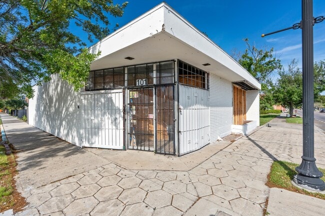

This Property Is For Sale
Property Detail
101 E 8Th St
071835-0000
2-4 37-2S-26E SPRINGFIELD W 40FT LOT 1 BLK 53
Storebuilding
Duval
CCG-S
Florida
B and X Area of moderate flood hazard, usually the area between the limits of the 100-year and 500-year floods.
1
2025
0.06 AC
2026
Downtown Northbank
001200
Jacksonville (Florida)
2,355 SF
Jacksonville, FL
NEARBY LISTINGS FOR SALE OR LEASE
DEMOGRAPHICS near 101 E 8Th St
1 mile
3 mile
5 mile
2025 Total Population
15,872
90,090
229,224
2030 Population
17,408
97,446
245,105
Pop Growth 2025-2030
+ 9.68%
+ 8.17%
+ 6.93%
Average Age
38
39
39
2025 Total Households
6,481
37,992
94,772
HH Growth 2025-2030
+ 10.20%
+ 8.67%
+ 7.35%
Median Household Inc
$40,548
$37,919
$46,685
Avg Household Size
2.20
2.20
2.30
2025 Avg HH Vehicles
1.00
1.00
1.00
Median Home Value
$328,142
$180,673
$236,955
Median Year Built
1954
1964
1964
Nearby Places
Map Layers
Map Styles
 Street
 Aerial
Transit
 Traffic
 Biking
Places
Listings with unknown addresses are not visible on the map
- Restaurants
- Banks
- Shops
- Fitness
- Groceries
PUBLIC TRANSPORTATION
COMMUTER RAIL
Drive
Walk
Distance
11 min
5.3 mi
AIRPORT
Jacksonville International
Drive
Walk
Distance
Jacksonville International
22 min
13.9 mi
Freight Ports
Jacksonville Port
Drive
Walk
Distance
Jacksonville Port
7 min
2.4 mi
Nearby Properties
Address
Land Use
TOTAL SIZE
Lot Size
Zoning
Address
Land Use
TOTAL SIZE
Lot Size
Zoning
1,086,885 SF
16.34 AC
CCBD
Address
Land Use
TOTAL SIZE
Lot Size
Zoning
543,383 SF
7.87 AC
CCBD
Address
Land Use
TOTAL SIZE
Lot Size
Zoning
1,150,143 SF
43.90 AC
CCBD
Address
Land Use
TOTAL SIZE
Lot Size
Zoning
705,940 SF
25.12 AC
PBF-1
Address
Land Use
TOTAL SIZE
Lot Size
Zoning
442,972 SF
5.33 AC
PUD
Address
Land Use
TOTAL SIZE
Lot Size
Zoning
1,146,106 SF
206.66 AC
PBF-2
Address
Land Use
TOTAL SIZE
Lot Size
Zoning
165,408 SF
2.45 AC
CCBD
Address
Land Use
TOTAL SIZE
Lot Size
Zoning
407,122 SF
4.50 AC
CCBD
Address
Land Use
TOTAL SIZE
Lot Size
Zoning
521,850 SF
10.06 AC
CCBD
Address
Land Use
TOTAL SIZE
Lot Size
Zoning
831,560 SF
1.16 AC
PUD
Address
Land Use
TOTAL SIZE
Lot Size
Zoning
187,278 SF
1.71 AC
CCBD
Address
Land Use
TOTAL SIZE
Lot Size
Zoning
257,667 SF
3.91 AC
CCBD
Address
Land Use
TOTAL SIZE
Lot Size
Zoning
127,732 SF
1.44 AC
CCBD
Address
Land Use
TOTAL SIZE
Lot Size
Zoning
224,600 SF
3.41 AC
PUD
Address
Land Use
TOTAL SIZE
Lot Size
Zoning
313,472 SF
35.44 AC
CCBD
Address
Land Use
TOTAL SIZE
Lot Size
Zoning
355,967 SF
8.98 AC
PUD
Address
Land Use
TOTAL SIZE
Lot Size
Zoning
700,443 SF
8 AC
CCBD
Address
Land Use
TOTAL SIZE
Lot Size
Zoning
264,277 SF
2.07 AC
CCBD
Address
Land Use
TOTAL SIZE
Lot Size
Zoning
503,858 SF
1.32 AC
CCBD
Address
Land Use
TOTAL SIZE
Lot Size
Zoning
369,638 SF
6.30 AC
CCBD
Address
Land Use
TOTAL SIZE
Lot Size
Zoning
448,709 SF
2.97 AC
CCBD
Address
Land Use
TOTAL SIZE
Lot Size
Zoning
326,485 SF
1.56 AC
CCBD
Address
Land Use
TOTAL SIZE
Lot Size
Zoning
453,728 SF
8.20 AC
CCBD
Address
Land Use
TOTAL SIZE
Lot Size
Zoning
194,877 SF
11.64 AC
CCBD
Address
Land Use
TOTAL SIZE
Lot Size
Zoning
299,055 SF
18.93 AC
CCBD
Address
Land Use
TOTAL SIZE
Lot Size
Zoning
336,623 SF
2.06 AC
CCBD
Address
Land Use
TOTAL SIZE
Lot Size
Zoning
253,858 SF
4.93 AC
PUD
Address
Land Use
TOTAL SIZE
Lot Size
Zoning
212,152 SF
8.17 AC
CCBD
Address
Land Use
TOTAL SIZE
Lot Size
Zoning
146,636 SF
2.88 AC
CCBD
Address
Land Use
TOTAL SIZE
Lot Size
Zoning
270,000 SF
8.90 AC
PUD
The World's #1 Commercial Real Estate Marketplace
Connect with us
© 2026 CoStar Group
The information above has been obtained from sources believed reliable. While we do not doubt its accuracy we have not verified it and make no guarantee, warranty or representation about it. It is your responsibility to independently confirm its accuracy and completeness. Any projections, opinions, assumptions, or estimates used are for example only and do not represent the current or future performance of the property. The value of this transaction to you depends on tax and other factors which should be evaluated by your tax, financial, and legal advisors. You and your advisors should conduct a careful, independent investigation of the property to determine to your satisfaction the suitability of the property for your needs.