Property Record
101 E Corry St, Cincinnati, OH 45219
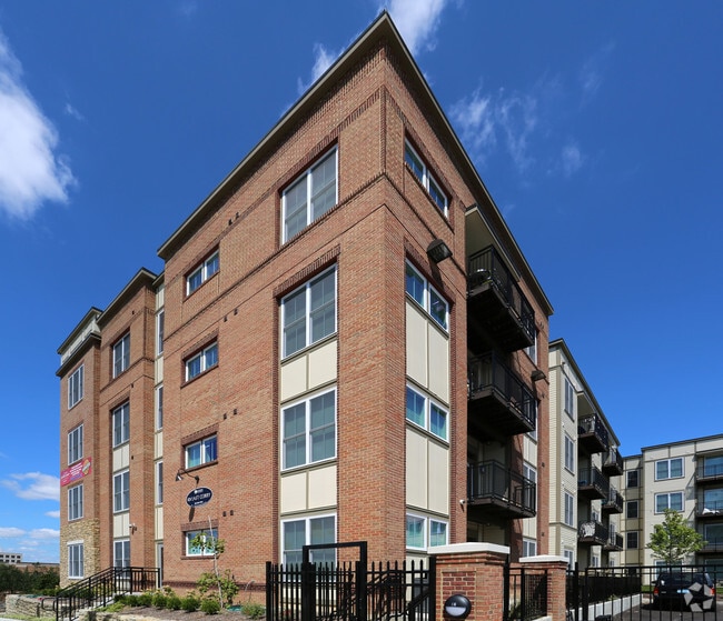

Property Detail
101 E Corry St
092-0002-0084
CORRY 2.0855 ACS
Apartment
Hamilton
OG
Ohio
B and X Area of moderate flood hazard, usually the area between the limits of the 100-year and 500-year floods.
2.09 AC
2025
Corryville
2025
Cincinnati/Dayton
003300
Cincinnati, OH-KY-IN
5,565 SF
NEARBY LISTINGS FOR SALE OR LEASE
DEMOGRAPHICS near 101 E Corry St
1 mile
3 mile
5 mile
2025 Total Population
31,567
152,622
344,333
2030 Population
32,429
157,389
352,358
Pop Growth 2025-2030
+ 2.73%
+ 3.12%
+ 2.33%
Average Age
29
36
37
2025 Total Households
11,225
68,801
153,047
HH Growth 2025-2030
+ 3.29%
+ 3.37%
+ 2.44%
Median Household Inc
$40,946
$54,223
$57,200
Avg Household Size
2.00
1.90
2.10
2025 Avg HH Vehicles
1.00
1.00
1.00
Median Home Value
$268,913
$292,177
$264,135
Median Year Built
1950
1948
1949
Nearby Places
Map Layers
Map Styles
 Street
 Aerial
Transit
 Traffic
 Biking
Places
Listings with unknown addresses are not visible on the map
- Restaurants
- Banks
- Shops
- Fitness
- Groceries
PUBLIC TRANSPORTATION
TRANSIT/SUBWAY
Brewery District Station - Elm & Henry (Streetcar - OTR - Banks - Southwest Ohio Regional Transit Authority)
Drive
Walk
Distance
Brewery District Station - Elm & Henry (Streetcar - OTR - Banks - Southwest Ohio Regional Transit Authority)
3 min
20 min
1.1 mi
COMMUTER RAIL
Cincinnati Union Terminal (Cardinal - Amtrak)
Drive
Walk
Distance
Cincinnati Union Terminal (Cardinal - Amtrak)
8 min
2.6 mi
AIRPORT
Cincinnati/Northern Kentucky International
Drive
Walk
Distance
Cincinnati/Northern Kentucky International
32 min
16.2 mi
Freight Ports
Port of Toledo
Drive
Walk
Distance
Port of Toledo
239 min
202.9 mi
Nearby Properties
Address
Land Use
TOTAL SIZE
Lot Size
Zoning
Address
Land Use
TOTAL SIZE
Lot Size
Zoning
77.73 AC
IR
Address
Land Use
TOTAL SIZE
Lot Size
Zoning
6.35 AC
IR
Address
Land Use
TOTAL SIZE
Lot Size
Zoning
39.99 AC
MG
Address
Land Use
TOTAL SIZE
Lot Size
Zoning
11.82 AC
Address
Land Use
TOTAL SIZE
Lot Size
Zoning
11.62 AC
Address
Land Use
TOTAL SIZE
Lot Size
Zoning
19.36 AC
Address
Land Use
TOTAL SIZE
Lot Size
Zoning
17.10 AC
DD
Address
Land Use
TOTAL SIZE
Lot Size
Zoning
1.97 AC
DD
Address
Land Use
TOTAL SIZE
Lot Size
Zoning
62.10 AC
Address
Land Use
TOTAL SIZE
Lot Size
Zoning
11.41 AC
IR
Address
Land Use
TOTAL SIZE
Lot Size
Zoning
22.45 AC
Address
Land Use
TOTAL SIZE
Lot Size
Zoning
13.80 AC
Address
Land Use
TOTAL SIZE
Lot Size
Zoning
9.55 AC
Address
Land Use
TOTAL SIZE
Lot Size
Zoning
3.09 AC
Address
Land Use
TOTAL SIZE
Lot Size
Zoning
2.80 AC
IR
Address
Land Use
TOTAL SIZE
Lot Size
Zoning
3.40 AC
IR
Address
Land Use
TOTAL SIZE
Lot Size
Zoning
89,500 SF
0.58 AC
Address
Land Use
TOTAL SIZE
Lot Size
Zoning
Address
Land Use
TOTAL SIZE
Lot Size
Zoning
290,233 SF
Address
Land Use
TOTAL SIZE
Lot Size
Zoning
3.51 AC
DD
Address
Land Use
TOTAL SIZE
Lot Size
Zoning
Address
Land Use
TOTAL SIZE
Lot Size
Zoning
153,312 SF
4 AC
Address
Land Use
TOTAL SIZE
Lot Size
Zoning
9.14 AC
Address
Land Use
TOTAL SIZE
Lot Size
Zoning
298,611 SF
Address
Land Use
TOTAL SIZE
Lot Size
Zoning
2.46 AC
Address
Land Use
TOTAL SIZE
Lot Size
Zoning
7.14 AC
Address
Land Use
TOTAL SIZE
Lot Size
Zoning
256,000 SF
Address
Land Use
TOTAL SIZE
Lot Size
Zoning
1.95 AC
Address
Land Use
TOTAL SIZE
Lot Size
Zoning
Address
Land Use
TOTAL SIZE
Lot Size
Zoning
263,300 SF
1.74 AC
The World's #1 Commercial Real Estate Marketplace
Connect with us
© 2026 CoStar Group
The information above has been obtained from sources believed reliable. While we do not doubt its accuracy we have not verified it and make no guarantee, warranty or representation about it. It is your responsibility to independently confirm its accuracy and completeness. Any projections, opinions, assumptions, or estimates used are for example only and do not represent the current or future performance of the property. The value of this transaction to you depends on tax and other factors which should be evaluated by your tax, financial, and legal advisors. You and your advisors should conduct a careful, independent investigation of the property to determine to your satisfaction the suitability of the property for your needs.