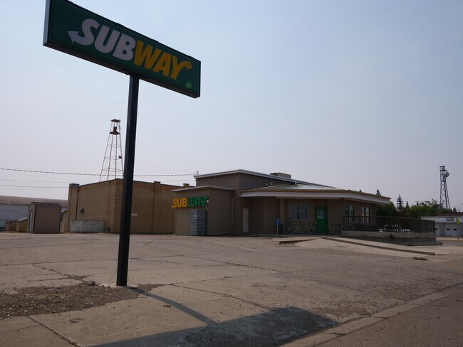
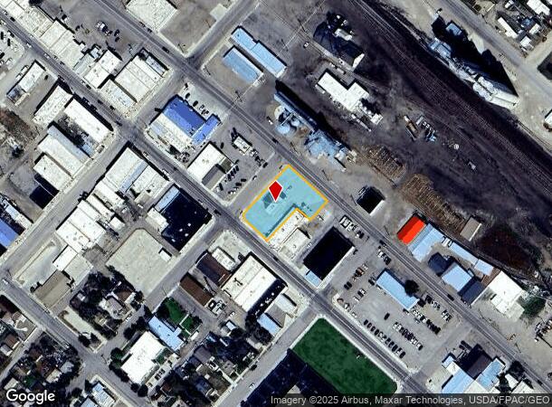
Property Record
101 E Main St, Cut Bank, MT 59427
NEARBY LISTINGS FOR SALE OR LEASE
Property Detail
101 E Main St
Other Market Areas
Cut Bank Original Townsite
38-4529-12-1-08-01-0000
CUT BANK ORIGINAL TOWNSITE, S12, T33 N, R06 W, BLOCK 011, LOT 001 - 005, N 75 FT OF LOT 5 LESS R/W
Restaurantdrivein
Glacier
2025
Montana
2025
5,1-005
976000
0.54 AC
1,511 SF
Montana Other Areas
DEMOGRAPHICS near 101 E Main St
1 Mile
3 Mile
5 Mile
2024 Total Population
3,638
3,911
4,295
2029 Population
3,691
3,958
4,331
Pop Growth 2024-2029
+ 1.46%
+ 1.20%
+ 0.84%
Average Age
39
39
39
2024 Total Households
1,517
1,616
1,744
HH Growth 2024-2029
+ 1.38%
+ 1.18%
+ 0.92%
Median Household Inc
$45,081
$45,363
$46,151
Avg Household Size
2.30
2.30
2.40
2024 Avg HH Vehicles
2.00
2.00
2.00
Median Home Value
$118,861
$123,712
$130,967
Median Year Built
1955
1956
1956
Nearby Places
Map Layers
Map Styles
 Street
 Aerial
- Restaurants
- Banks
- Shops
- Fitness
- Groceries
PUBLIC TRANSPORTATION
COMMUTER RAIL
Cut Bank Amtrak Station (Empire Builder - Amtrak)
DRIVE
WALK
Distance
Cut Bank Amtrak Station (Empire Builder - Amtrak)
0 min
3 min
0.2 mi
Freight Ports
Port of Everett
DRIVE
WALK
Distance
Port of Everett
783 min
679.0 mi
SALE & LEASE HISTORY
LISTING DATE
SALE/LEASE

Oct 27, 2021
For Sale
Jun 15, 2023
For Sale
Nearby Properties
Address
Land Use
TOTAL SIZE
Lot Size
Zoning
Address
Land Use
TOTAL SIZE
Lot Size
Zoning
58,201 SF
4.04 AC
1
Address
Land Use
TOTAL SIZE
Lot Size
Zoning
95,426 SF
3.21 AC
1
Address
Land Use
TOTAL SIZE
Lot Size
Zoning
170 SF
5.19 AC
Address
Land Use
TOTAL SIZE
Lot Size
Zoning
30,336 SF
2.78 AC
6
Address
Land Use
TOTAL SIZE
Lot Size
Zoning
6,528 SF
2.20 AC
1
Address
Land Use
TOTAL SIZE
Lot Size
Zoning
9,212 SF
1.20 AC
Address
Land Use
TOTAL SIZE
Lot Size
Zoning
12,747 SF
0.31 AC
5
Address
Land Use
TOTAL SIZE
Lot Size
Zoning
19,076 SF
1.64 AC
6
Address
Land Use
TOTAL SIZE
Lot Size
Zoning
9,814 SF
1.45 AC
1
Address
Land Use
TOTAL SIZE
Lot Size
Zoning
19,168 SF
0.64 AC
1
Address
Land Use
TOTAL SIZE
Lot Size
Zoning
6,527 SF
0.72 AC
6
Address
Land Use
TOTAL SIZE
Lot Size
Zoning
3,600 SF
0.92 AC
1
Address
Land Use
TOTAL SIZE
Lot Size
Zoning
2,870 SF
1.53 AC
1
Address
Land Use
TOTAL SIZE
Lot Size
Zoning
13.13 AC
Address
Land Use
TOTAL SIZE
Lot Size
Zoning
11,234 SF
0.34 AC
5
Address
Land Use
TOTAL SIZE
Lot Size
Zoning
5,548 SF
0.50 AC
1
Address
Land Use
TOTAL SIZE
Lot Size
Zoning
18,062 SF
0.48 AC
1
Address
Land Use
TOTAL SIZE
Lot Size
Zoning
5,463 SF
2.31 AC
1
Address
Land Use
TOTAL SIZE
Lot Size
Zoning
10,296 SF
2.08 AC
Address
Land Use
TOTAL SIZE
Lot Size
Zoning
9,800 SF
1.63 AC
Address
Land Use
TOTAL SIZE
Lot Size
Zoning
1,936 SF
Address
Land Use
TOTAL SIZE
Lot Size
Zoning
6,080 SF
0.96 AC
Address
Land Use
TOTAL SIZE
Lot Size
Zoning
12,484 SF
1.23 AC
6
Address
Land Use
TOTAL SIZE
Lot Size
Zoning
7,310 SF
1.97 AC
Address
Land Use
TOTAL SIZE
Lot Size
Zoning
8,880 SF
0.32 AC
1
Address
Land Use
TOTAL SIZE
Lot Size
Zoning
11,600 SF
1.03 AC
1
Address
Land Use
TOTAL SIZE
Lot Size
Zoning
3,094 SF
0.67 AC
6
Address
Land Use
TOTAL SIZE
Lot Size
Zoning
7,652 SF
0.82 AC
6
Address
Land Use
TOTAL SIZE
Lot Size
Zoning
2,400 SF
1.09 AC
Address
Land Use
TOTAL SIZE
Lot Size
Zoning
11,965 SF
0.82 AC
6
The World's #1 Commercial Real Estate Marketplace
Connect with us
© 2025 CoStar Group
The information above has been obtained from sources believed reliable. While we do not doubt its accuracy we have not verified it and make no guarantee, warranty or representation about it. It is your responsibility to independently confirm its accuracy and completeness. Any projections, opinions, assumptions, or estimates used are for example only and do not represent the current or future performance of the property. The value of this transaction to you depends on tax and other factors which should be evaluated by your tax, financial, and legal advisors. You and your advisors should conduct a careful, independent investigation of the property to determine to your satisfaction the suitability of the property for your needs.