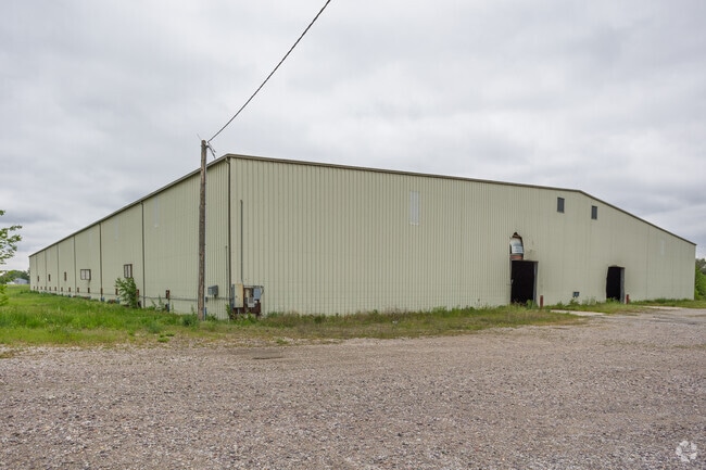
Property Record
101 Grant St N, Bondurant, IA 50035
Current Lease Availabilities
NEARBY LISTINGS FOR SALE OR LEASE
Property Detail
101 Grant St N
Des Moines-West Des Moines, IA
Sec 31-80-22
231-00055002000
BEG SW COR LOT 1 BLK 11 OFF REP LOTS 10 THRU 12 ORIG PLAT BONDURANT THN NELY 294.90F THN S 209.66F THN SWLY 294.90F THN N 209.66F TO PT OF BEG SEC 31-80-22
Federalproperty
Polk
X
Iowa
19153C0230F
1
0
1.35 AC
2025
Northeast
010102
Des Moines
8,239 SF
DEMOGRAPHICS near 101 Grant St N
1 Mile
3 Mile
5 Mile
2024 Total Population
6,740
10,855
30,259
2029 Population
7,215
11,740
32,139
Pop Growth 2024-2029
+ 7.05%
+ 8.15%
+ 6.21%
Average Age
32
34
37
2024 Total Households
2,136
3,532
11,005
HH Growth 2024-2029
+ 7.02%
+ 8.18%
+ 6.07%
Median Household Inc
$108,026
$107,549
$90,773
Avg Household Size
3.10
3.10
2.70
2024 Avg HH Vehicles
2.00
2.00
2.00
Median Home Value
$256,957
$276,756
$261,687
Median Year Built
2010
2010
2001
Nearby Places
Map Layers
Map Styles
 Street
 Aerial
- Restaurants
- Banks
- Shops
- Fitness
- Groceries
PUBLIC TRANSPORTATION
AIRPORT
Des Moines International
DRIVE
WALK
Distance
Des Moines International
33 min
19.3 mi
Freight Ports
Port Milwaukee
DRIVE
WALK
Distance
Port Milwaukee
405 min
364.5 mi
Nearby Properties
Address
Land Use
TOTAL SIZE
Lot Size
Zoning
Address
Land Use
TOTAL SIZE
Lot Size
Zoning
2,693,534 SF
167.13 AC
Address
Land Use
TOTAL SIZE
Lot Size
Zoning
497,587 SF
31.46 AC
Address
Land Use
TOTAL SIZE
Lot Size
Zoning
459,000 SF
19.69 AC
Address
Land Use
TOTAL SIZE
Lot Size
Zoning
279,650 SF
48.24 AC
Address
Land Use
TOTAL SIZE
Lot Size
Zoning
397,563 SF
18.25 AC
Address
Land Use
TOTAL SIZE
Lot Size
Zoning
327,600 SF
16.57 AC
Address
Land Use
TOTAL SIZE
Lot Size
Zoning
212,388 SF
40.63 AC
Address
Land Use
TOTAL SIZE
Lot Size
Zoning
325,160 SF
17.24 AC
Address
Land Use
TOTAL SIZE
Lot Size
Zoning
302,604 SF
16.46 AC
Address
Land Use
TOTAL SIZE
Lot Size
Zoning
265,726 SF
14.76 AC
Address
Land Use
TOTAL SIZE
Lot Size
Zoning
300,000 SF
18.95 AC
Address
Land Use
TOTAL SIZE
Lot Size
Zoning
300,000 SF
20.09 AC
Address
Land Use
TOTAL SIZE
Lot Size
Zoning
270,000 SF
18.35 AC
Address
Land Use
TOTAL SIZE
Lot Size
Zoning
270,000 SF
14.55 AC
Address
Land Use
TOTAL SIZE
Lot Size
Zoning
195,500 SF
15.03 AC
Address
Land Use
TOTAL SIZE
Lot Size
Zoning
195,500 SF
8.09 AC
Address
Land Use
TOTAL SIZE
Lot Size
Zoning
167,308 SF
16.46 AC
Address
Land Use
TOTAL SIZE
Lot Size
Zoning
106,824 SF
4.50 AC
Address
Land Use
TOTAL SIZE
Lot Size
Zoning
78,180 SF
7.31 AC
Address
Land Use
TOTAL SIZE
Lot Size
Zoning
135,824 SF
13.22 AC
Address
Land Use
TOTAL SIZE
Lot Size
Zoning
49,145 SF
6.06 AC
Address
Land Use
TOTAL SIZE
Lot Size
Zoning
134,400 SF
6.01 AC
M-1
Address
Land Use
TOTAL SIZE
Lot Size
Zoning
27,908 SF
14.43 AC
Address
Land Use
TOTAL SIZE
Lot Size
Zoning
72,024 SF
30 AC
Address
Land Use
TOTAL SIZE
Lot Size
Zoning
12,439 SF
6.87 AC
Address
Land Use
TOTAL SIZE
Lot Size
Zoning
29,000 SF
6.36 AC
M-1
Address
Land Use
TOTAL SIZE
Lot Size
Zoning
38,997 SF
5.86 AC
R-3
Address
Land Use
TOTAL SIZE
Lot Size
Zoning
34,960 SF
14.09 AC
Address
Land Use
TOTAL SIZE
Lot Size
Zoning
60,321 SF
3.29 AC
C-2
The World's #1 Commercial Real Estate Marketplace
Connect with us
© 2025 CoStar Group
The information above has been obtained from sources believed reliable. While we do not doubt its accuracy we have not verified it and make no guarantee, warranty or representation about it. It is your responsibility to independently confirm its accuracy and completeness. Any projections, opinions, assumptions, or estimates used are for example only and do not represent the current or future performance of the property. The value of this transaction to you depends on tax and other factors which should be evaluated by your tax, financial, and legal advisors. You and your advisors should conduct a careful, independent investigation of the property to determine to your satisfaction the suitability of the property for your needs.