Property Record
Industrial Pkwy, Mound House, NV 89706
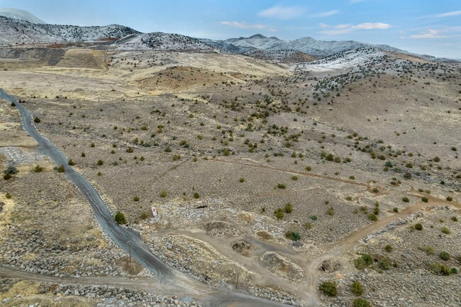

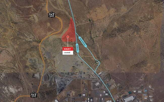
This Property Is For Sale
NEARBY LISTINGS FOR SALE OR LEASE
Property Detail
Industrial Pkwy
016-411-27
/PAR 1 AROS/IND 11-16- 21 FR NW4 CREATED FROM SPLIT OF PARCEL # 016-151-72 PRIMARY NEW PARCEL IS PARCEL # 016-411-06 FR NE4 / PAR 1 OF AROS/IND.SUB #296058 CHANGED FROM PARCEL # 016-411-04 BAM#444613 NW4
Industrialacreage
Lyon
X
Nevada
3200010110F
9.45 AC
2026
Lyon County
2025
Reno/Sparks
000900
Fernley, NV
DEMOGRAPHICS near Industrial Pkwy
1 Mile
3 Mile
5 Mile
2024 Total Population
5
1,678
8,014
2029 Population
5
1,864
8,890
Pop Growth 2024-2029
0.00%
+ 11.08%
+ 10.93%
Average Age
0
43
43
2024 Total Households
2
666
3,166
HH Growth 2024-2029
0.00%
+ 11.26%
+ 10.80%
Median Household Inc
$112,500
$68,157
$80,538
Avg Household Size
1.50
2.50
2.50
2024 Avg HH Vehicles
2.00
2.00
2.00
Median Home Value
$250,000
$278,324
$373,781
Median Year Built
1984
1987
1987
Nearby Places
Map Layers
Map Styles
 Street
 Aerial
- Restaurants
- Banks
- Shops
- Fitness
- Groceries
PUBLIC TRANSPORTATION
AIRPORT
Reno/Tahoe International
DRIVE
WALK
Distance
Reno/Tahoe International
65 min
38.9 mi
Freight Ports
Port of Stockton
DRIVE
WALK
Distance
Port of Stockton
234 min
160.7 mi
Nearby Properties
Address
Land Use
TOTAL SIZE
Lot Size
Zoning
Address
Land Use
TOTAL SIZE
Lot Size
Zoning
4.51 AC
RR3
Address
Land Use
TOTAL SIZE
Lot Size
Zoning
100,947 SF
15 AC
M1
Address
Land Use
TOTAL SIZE
Lot Size
Zoning
108.58 AC
PR
Address
Land Use
TOTAL SIZE
Lot Size
Zoning
83,961 SF
10 AC
M1
Address
Land Use
TOTAL SIZE
Lot Size
Zoning
1,590 SF
10.16 AC
M1
Address
Land Use
TOTAL SIZE
Lot Size
Zoning
28,000 SF
7.78 AC
M1
Address
Land Use
TOTAL SIZE
Lot Size
Zoning
22,200 SF
4.27 AC
M1
Address
Land Use
TOTAL SIZE
Lot Size
Zoning
69,600 SF
5.85 AC
M1
Address
Land Use
TOTAL SIZE
Lot Size
Zoning
86,500 SF
6.41 AC
M1
Address
Land Use
TOTAL SIZE
Lot Size
Zoning
27,000 SF
6.19 AC
M1
Address
Land Use
TOTAL SIZE
Lot Size
Zoning
4,950 SF
2.69 AC
M1
Address
Land Use
TOTAL SIZE
Lot Size
Zoning
331.93 AC
PR
Address
Land Use
TOTAL SIZE
Lot Size
Zoning
2,795 SF
7.05 AC
JW
Address
Land Use
TOTAL SIZE
Lot Size
Zoning
10,875 SF
15.10 AC
GI
Address
Land Use
TOTAL SIZE
Lot Size
Zoning
28,425 SF
3.85 AC
M1
Address
Land Use
TOTAL SIZE
Lot Size
Zoning
34,700 SF
5.35 AC
M1
Address
Land Use
TOTAL SIZE
Lot Size
Zoning
4,350 SF
2.50 AC
M1
Address
Land Use
TOTAL SIZE
Lot Size
Zoning
33,600 SF
3.90 AC
M1
Address
Land Use
TOTAL SIZE
Lot Size
Zoning
10,000 SF
8.31 AC
M1
Address
Land Use
TOTAL SIZE
Lot Size
Zoning
4,648 SF
4.97 AC
GI
Address
Land Use
TOTAL SIZE
Lot Size
Zoning
8,000 SF
16 AC
M1
Address
Land Use
TOTAL SIZE
Lot Size
Zoning
6,250 SF
2 AC
M1
Address
Land Use
TOTAL SIZE
Lot Size
Zoning
7,542 SF
7.43 AC
M1
Address
Land Use
TOTAL SIZE
Lot Size
Zoning
5,000 SF
3.56 AC
M1
Address
Land Use
TOTAL SIZE
Lot Size
Zoning
18,000 SF
1.99 AC
M1
Address
Land Use
TOTAL SIZE
Lot Size
Zoning
9,600 SF
4.66 AC
M1
Address
Land Use
TOTAL SIZE
Lot Size
Zoning
53,040 SF
5.44 AC
M1
Address
Land Use
TOTAL SIZE
Lot Size
Zoning
7,500 SF
2.16 AC
M1
Address
Land Use
TOTAL SIZE
Lot Size
Zoning
8,800 SF
3.51 AC
M1
Address
Land Use
TOTAL SIZE
Lot Size
Zoning
4,000 SF
5.78 AC
M1
The World's #1 Commercial Real Estate Marketplace
Connect with us
© 2025 CoStar Group
The information above has been obtained from sources believed reliable. While we do not doubt its accuracy we have not verified it and make no guarantee, warranty or representation about it. It is your responsibility to independently confirm its accuracy and completeness. Any projections, opinions, assumptions, or estimates used are for example only and do not represent the current or future performance of the property. The value of this transaction to you depends on tax and other factors which should be evaluated by your tax, financial, and legal advisors. You and your advisors should conduct a careful, independent investigation of the property to determine to your satisfaction the suitability of the property for your needs.